Gippsland railway line

Last updated

Gippsland line
VLine VL87 Traralgon.jpg
Overview
StatusOperational from Flinders Street to Bairnsdale, closed beyond Bairnsdale
Owner VicTrack
Locale Victoria, Australia
Termini
Service
Services Bairnsdale
Cranbourne
Pakenham
Traralgon
Operator(s)Passenger: Metro Trains, V/Line
Freight: Multiple
History
Commenced1877;146 years ago (1877)
Completed1916;107 years ago (1916)
Technical
Number of tracks Double track between Melbourne and Garfield, Drouin and just before Moe, single track between Bunyip and Longwarry and beyond Moe except for two passing loops at Hernes Oak and before Morwell
Track gauge 1,600 mm (5 ft 3 in)
Electrification 1500 V DC overhead between Flinders Street and Pakenham
Route map

Contents

km
BSicon CONTg.svg
BSicon INT.svg
0.00
Flinders Street
BSicon eHST.svg
0.35
Princes Bridge
BSicon ABZgl+l.svg
BSicon CONTfq.svg
BSicon ABZgl.svg
BSicon CONTfq.svg
BSicon INT.svg
2.40
Richmond
BSicon ABZgl.svg
BSicon CONTfq.svg
BSicon hSKRZ-G4a.svg
BSicon hbKRZWe.svg
BSicon INT.svg
4.20
South Yarra
BSicon CONTgq.svg
BSicon ABZgr.svg
BSicon eABZg+l.svg
BSicon exCONTfq.svg
BSicon HST.svg
5.40
Hawksburn
BSicon HST.svg
6.70
Toorak
BSicon HST.svg
7.40
Armadale
BSicon HST.svg
8.90
Malvern
BSicon INT.svg
10.60
Caulfield
BSicon CONTgq.svg
BSicon ABZgr.svg
BSicon hHSTa.svg
12.30
Carnegie
BSicon hHST.svg
13.20
Murrumbeena
BSicon ehABZg+l.svg
BSicon exhCONTfq.svg
BSicon hHSTe.svg
14.20
Hughesdale
BSicon exCONTgq.svg
BSicon eABZg+r.svg
BSicon HST.svg
15.40
Oakleigh
BSicon HST.svg
17.00
Huntingdale
BSicon hINTae.svg
19.20
Clayton
BSicon HST.svg
21.40
Westall
BSicon HST.svg
23.30
Springvale
BSicon eABZgl.svg
BSicon exCONTfq.svg
Spring Vale Cemetery line
to Spring Vale Cemetery
BSicon HST.svg
24.40
Sandown Park
BSicon hHSTa.svg
25.10
Noble Park
BSicon hbKRZWe.svg
Mile Creek
BSicon HST.svg
27.80
Yarraman
BSicon SKRZ-G4u.svg
BSicon hbKRZWae.svg
Yarraman Creek
BSicon INT.svg
30.00
Dandenong
BSicon hbKRZWae.svg
BSicon CONTgq.svg
BSicon ABZgr.svg
BSicon hbKRZWae.svg
Eumemmering Creek
BSicon eHST.svg
33.80
General Motors
BSicon SKRZ-G4u.svg
BSicon HST.svg
36.20
Hallam
BSicon hbKRZWae.svg
Troups Creek
BSicon HST.svg
39.50
Narre Warren
BSicon SKRZ-G4u.svg
BSicon INT.svg
43.40
Berwick
BSicon hbKRZWae.svg
BSicon HST.svg
45.80
Beaconsfield
BSicon HST.svg
50.20
Officer
BSicon hbKRZWae.svg
Gum Scrub Creek
BSicon HST.svg
54.60
Cardinia Road
BSicon hbKRZWae.svg
Toomuc Creek
BSicon INT.svg
56.90
Pakenham
BSicon eHST.svg
East Pakenham
(planning)
BSicon MFADEg.svg
BSicon GRZ.svg
BSicon SKRZ-G4u.svg
BSicon ELCe.svg
BSicon ABZgl.svg
BSicon KDSTeq.svg
Pakenham East Depot
BSicon HST.svg
63.40
Nar Nar Goon
BSicon HST.svg
69.50
Tynong
BSicon INT.svg
72.66
Garfield
BSicon HST.svg
77.90
Bunyip
BSicon HST.svg
82.30
Longwarry
BSicon INT.svg
90.99
Drouin
BSicon SKRZ-G4u.svg
BSicon INT.svg
101.76
Warragul
BSicon eABZgl.svg
BSicon exCONTfq.svg
Noojee line
to Noojee
BSicon eHST.svg
104.20
Nilma
BSicon eHST.svg
108.50
Darnum
BSicon HST.svg
114.20
Yarragon
BSicon HST.svg
122.30
Trafalgar
BSicon eABZg+l.svg
BSicon exCONTfq.svg
BSicon INT.svg
132.22
Moe
BSicon eABZgl.svg
BSicon exCONTfq.svg
BSicon exCONTgq.svg
BSicon eABZgr.svg
Thorpdale line
to Thorpdale
BSicon eHST.svg
140.00
Hernes Oak
BSicon eABZgl.svg
BSicon exCONTfq.svg
BSicon exCONTgq.svg
BSicon eKRZu.svg
BSicon exCONTfq.svg
Yallourn 900mm Railway
to Hazelwood – to Yallourn
BSicon exCONTgq.svg
BSicon eABZg+r.svg
Mirboo North line
to Mirboo North
BSicon HST.svg
146.37
Morwell
BSicon eHST.svg
148.30
Maryvale
BSicon SKRZ-G4u.svg
BSicon INT.svg
160.07
Traralgon
BSicon eKRWgl.svg
BSicon exLKRW+r.svg
BSicon eHST.svg
167.00
Loy Yang
BSicon eHST.svg
173.80
Flynn
BSicon HST.svg
182.36
Rosedale
BSicon eHST.svg
192.30
Kilmany
BSicon eHST.svg
199.70
Fulham
BSicon HST.svg
208.02
Sale
BSicon eHST.svg
218.00
Montgomery
BSicon eKRWg+l.svg
BSicon exLKRWr.svg
BSicon eHST.svg
Stratford Junction
BSicon HST.svg
224.10
Stratford
BSicon eHST.svg
233.40
Munro
BSicon eHST.svg
246.20
Fernbank
BSicon eHST.svg
257.50
Lindenow
BSicon eHST.svg
262.90
Hillside
BSicon KHSTxe.svg
276.84
Bairnsdale
BSicon exENDEaq.svg
BSicon exABZgr.svg
Bairnsdale Wharf spur
BSicon exHST.svg
286.60
Nicholson
BSicon exHST.svg
296.10
Bumberrah
BSicon exHST.svg
303.90
Mossiface
BSicon exHST.svg
306.30
Bruthen
BSicon exHST.svg
321.40
Colquhoun
BSicon exHST.svg
336.10
Nowa Nowa
BSicon exHST.svg
345.80
Tostaree
BSicon exHST.svg
358.80
Waygara
BSicon exKHSTe.svg
372.60
Orbost
km

The Gippsland line (also known as the Orbost railway line or Bairnsdale railway line) is a railway line serving the Latrobe Valley and Gippsland regions of Victoria, Australia. It runs east from the state capital Melbourne through the cities of Moe, Morwell, Traralgon, Sale and terminating at Bairnsdale.

Prior to its dismantling in 1994, the line extended to Orbost. The dismantled section now comprises the East Gippsland Rail Trail, a shared bicycle, walking, and horseriding track. [1]

Services

Metro Trains Melbourne operates suburban passenger services along the inner section of the line as the Pakenham line, while V/Line services operate as the Traralgon and the Bairnsdale lines. Freight services also use the line, operated by Qube Holdings.

History

Double headed coal train passing westbound through Warragul station ~1920 Double headed coal train passing westbound through Warragul station ~1920.jpg
Double headed coal train passing westbound through Warragul station ~1920
Coal train passing through Moe Station, ~1920 Coal train passing through Moe Station, ~1920.jpg
Coal train passing through Moe Station, ~1920
Traralgon railway station ~1920 Traralgon railway station ~1920.jpg
Traralgon railway station ~1920
The current end of the line at Bairnsdale Line towards Orbost.jpg
The current end of the line at Bairnsdale
Section of line at Morwell Loop upgraded as part of the Regional Fast Rail project Gippsland-line-at-Hernes-Oak.jpg
Section of line at Morwell Loop upgraded as part of the Regional Fast Rail project

Rail lines were built to Gippsland in the 1870s and initially played a crucial role in developing agricultural industries in Gippsland as well as tourism. It also played a crucial role in the development of coal mining in the Latrobe Valley in the 1920s. At its peak, the railway travelled as far east as Orbost, and there are still frequent services to many of the towns. Some of the disused rail lines have been turned into tourist railways and/or rail trails.

The Melbourne and Suburban Railway Company opened a line from Princes Bridge railway station to Punt Road (Richmond) and South Yarra in 1859, Prahran in 1859 and Windsor in 1860, connecting with the St Kilda and Brighton Railway Company line. This line was extended to Dandenong, Pakenham, Warragul, Moe, Morwell, Traralgon, Sale, Stratford and Bairnsdale between 1877 and 1879. It was extended to Orbost in 1916.

The railway to Orbost opened in 1916 and operated until 1987, principally carrying timber and farming produce. In the early days of the railway's operation, dedicated passenger trains ran, but they had ceased by the 1930s. The track infrastructure was dismantled in 1994. The line traversed a mixture of farmland, hills and heavily forested country, and included numerous bridges, including the Stoney Creek trestle bridge, the largest of its kind in Victoria.

In 1954, the line from Dandenong to Traralgon was electrified, mainly because of the expected briquette traffic from the brown coal mines in the Latrobe Valley. Over the next two years most of the line between Dandenong and Pakenham was duplicated and provided with power signalling, although the Narre Warren to Berwick section was not done until 1962. Over time, the rail transport of briquettes petered out as industry converted to natural gas and homes were converted to other forms of heating.

Electrification was cut back to Warragul in 1987, with suburban-style trains providing the services from there to Melbourne. Electrification was further cut back to Bunyip in 1998, before ceasing entirely beyond Pakenham in 2001. The line east of Sale was closed in 1994, but was reopened to Bairnsdale in 2004. In 2005, the Regional Fast Rail project upgraded one of the two lines between Pakenham and Traralgon. This project also included removing the remaining electrification infrastructure from Pakenham East to Traralgon, with the exception of a heritage-listed length in Bunyip.

Branch lines

The Morwell Interconnecting Railway bridge crossing the Gippsland railway and Commercial Road, on the western edge of Morwell, 2007 Gippsland line crossed by ICR.jpg
The Morwell Interconnecting Railway bridge crossing the Gippsland railway and Commercial Road, on the western edge of Morwell, 2007

The Noojee railway line was built north from Warragul in stages from the 1890s, reaching Noojee in 1919. It was closed in stages from 1954 to 1958. [2]

In 1910, the 762 mm (2 ft 6 in) Walhalla railway line was completed through mountainous country from Moe to Erica and Walhalla. The Platina to Walhalla section closed in 1944, Erica to Platina in 1952, and Moe to Erica in 1954. [3] The northernmost section, between Thomson and Walhalla stations, has been reopened as a tourist railway by the Walhalla Goldfields Railway, and provides regularly scheduled trains.

The Thorpdale railway line was also opened from Moe to Thorpdale in 1888, it was closed in 1958.

The Yallourn branch was opened from Hernes Oak (between Moe and Morwell) to Yallourn in 1922 to serve the adjacent power station development. It was replaced by a line from Moe to Yallourn in 1953 because its route was required for brown coal mining, [4] but the new line closed in 1987, having been disused since the late 1970s. [4] [5]

The Mirboo North branch line was opened in stages from Morwell to Mirboo North between 1885 and 1886; however, it was closed in 1974. [6] The route of the line was partly dug up as part of the Hazelwood open cut mine. The Maryvale paper siding also connects to the main line at Morwell and remains open today for regular freight traffic.

The loop line via Maffra was opened from Traralgon to Heyfield, Maffra and Stratford in 1887, which was closed in stages between 1987 and 1993. A branch line was opened from Maffra to Briagolong in 1889 and closed in 1952.

There used to be several timber tramways running to a number of the stations between Pakenham and Yarragon.

Significance

The expansion of the railway in the late 1870s helped to develop Gippsland. It enabled milk from western Gippsland to be sold fresh into Melbourne while the dairy industry of East Gippsland provided cheese and butter. It also enabled development of west Gippsland's market gardening and orcharding industry for sale in Melbourne markets.

It also encouraged the development of a tourism industry notably at Lakes Entrance. It did, however, end coastal shipping traffic and the use of Sale and Bairnsdale as ports.

In the 1920s, the Gippsland railway played an important role in developing the mining of lignite coal and the development of the Latrobe Valley for power generation primarily serving Melbourne and Victoria. This saw the development of industry in towns such as Yallourn, Morwell, Traralgon, Moe, Warragul and Drouin.

The development of the Gippsland Railway helped fuel the Melbourne land boom in the 1870s. The original departure point for the railway was Oakleigh with the line connecting Oakleigh and Melbourne not built until 1879. The Victorian Railways bought land in Oakleigh for use as workshops. Oakleigh became a centre of what was known as "railway fever" as developers developed and marketed houses close to rail lines between Oakleigh and other suburbs for use of workers travelling to and from their job. At the height of the land boom in 1888, land sales were being held two or three times a week in the district. The collapse of the land boom in 1889 eventually contributed to banking collapses in 1893, and the major depression of the 1890s.

The Gippsland railway remains a significant passenger corridor on the V/Line network, although its use for freight business has now declined to only one major customer, being Australian Paper's export traffic from its mill in Maryvale.

Tourist railways and rail trails

Walhalla Goldfields Railway Walhalla Goldfields Railway.jpg
Walhalla Goldfields Railway

Many of the lines in Gippsland have closed because they had become uneconomic. Some of these have been turned into tourist railways, and other bits into rail trails. The only tourist railway left operating is the Walhalla Goldfields Railway between Moe and Walhalla. Until 2016, the South Gippsland Railway operated services between Leongatha and Nyora, via Korumburra, however, services ceased in 2015 and the line is now being converted to a rail trail.

Other stretches of line have become rail trails for use by bicyclists. These include:

Preserved substation and overhead wiring at Bunyip Bunyip station substation and overhead.jpg
Preserved substation and overhead wiring at Bunyip
An old section of the bridge across the Avon River near Stratford VM 0259 Stratford - Avon River Railway Bridge.jpg
An old section of the bridge across the Avon River near Stratford

Related Research Articles

<span class="mw-page-title-main">Traralgon</span> City in Victoria, Australia

Traralgon is a town located in the east of the Latrobe Valley in the Gippsland region of Victoria, Australia and the most populous city in the City of Latrobe and the region. The urban population of Traralgon at the 2021 census was 26,907. It is the largest and fastest growing city in the greater Latrobe Valley area, which has a population of 77,168 at the 2021 Census and is administered by the City of Latrobe.

<span class="mw-page-title-main">Morwell</span> City in Victoria, Australia

Morwell is a town in the Latrobe Valley area of Gippsland, in South-Eastern Victoria, Australia approximately 152 km (94 mi) east of Melbourne.

<span class="mw-page-title-main">Latrobe Valley</span> Region in Victoria, Australia

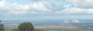
The Latrobe Valley is an inland geographical district and urban area of the Gippsland region in the state of Victoria, Australia. The traditional owners are the Brayakaulung of the Gunai nation. The district lies east of Melbourne and nestled between the Strzelecki Ranges to the south and the Baw Baw Ranges, part of the Great Dividing Range, to the north. Mount St Phillack is the highest peak to the north of the Latrobe Valley, due north of Moe. The highest peak to the south is Mt Tassie, south of Traralgon.

<span class="mw-page-title-main">City of Latrobe</span> Local government area in Victoria, Australia

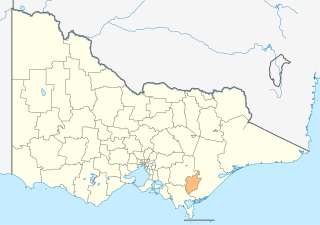
The City of Latrobe is a local government area in the Gippsland region in eastern Victoria, Australia, located in the eastern part of the state. It covers an area of 1,426 square kilometres (551 sq mi) and in June 2018 had a population of 75,211. It is primarily urban with the vast majority of its population living within the four major urban areas of Moe, Morwell, Traralgon, and Churchill, and other significant settlements in the LGA include Boolarra, Callignee, Glengarry, Jeeralang, Newborough, Toongabbie, Tyers, Yallourn North and Yinnar. It was formed in 1994 from the amalgamation of the City of Moe, City of Morwell, City of Traralgon, Shire of Traralgon, and parts of the Shire of Narracan and Shire of Rosedale. The Yallourn Works Area was added in 1996. When formed, the municipality was called the Shire of La Trobe, but on 6 April 2000, it adopted its current name.

<span class="mw-page-title-main">Dandenong railway station</span> Railway station in Melbourne, Australia

Dandenong railway station is the junction for the Pakenham and Cranbourne lines in Victoria, Australia. It serves the south-eastern Melbourne suburb of the same name, and opened on 8 October 1877.

The Gippsland V/Line rail service is a passenger service operated by V/Line in Victoria, Australia between Melbourne and the Gippsland region including the regional cities of Moe, Morwell, Traralgon, Sale and Bairnsdale. It operates along the Gippsland railway line.

<span class="mw-page-title-main">Tynong railway station</span> Railway station in Victoria, Australia

Tynong railway station is located on the Gippsland line in Victoria, Australia. It serves the town of Tynong, and it opened on 12 February 1880.

<span class="mw-page-title-main">Warragul railway station</span> Railway station in Victoria, Australia

Warragul railway station is located on the Gippsland line in Victoria, Australia. It serves the town of Warragul, and it opened on 1 March 1878 as Warrigal. It was renamed Warragul on 1 May 1879.

<span class="mw-page-title-main">Moe railway station</span> Railway station in Victoria, Australia

Moe railway station is located on the Gippsland line in Victoria, Australia. It serves the town of Moe, and it opened on 1 March 1878.

<span class="mw-page-title-main">Morwell railway station</span> Railway station in Victoria, Australia

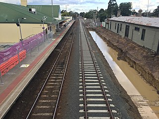
Morwell railway station is located on the Gippsland line in Victoria, Australia. It serves the town of Morwell, and it opened on 1 June 1877.

Mirboo North is a town in Victoria, Australia, located 150 kilometres (93 mi) east of Melbourne, with a population of 1,697. It is in the South Gippsland Shire local government area.

<span class="mw-page-title-main">Moe, Victoria</span> Town in Victoria, Australia

Moe is a town in the Latrobe Valley in the Gippsland region of Victoria, Australia. It is approximately 130 kilometres east of the central business district of Melbourne, 45 kilometres due south of the peak of Mount Baw Baw in the Great Dividing Range and features views of the Baw Baw Ranges to the north and Strzelecki Ranges to the south.

<span class="mw-page-title-main">Traralgon railway station</span> Railway station in Victoria, Australia

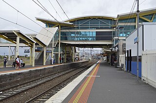
Traralgon railway station is located on the Gippsland line in Victoria, Australia. It serves the city of Traralgon, and it opened on 1 June 1877.

<span class="mw-page-title-main">Gippsland League</span>

The Gippsland League is an Australian rules football and netball league in the Gippsland region of Victoria, Australia. It is considered the only AFL Victoria major league in Gippsland.

<span class="mw-page-title-main">Shire of Narracan</span> Local government area in Victoria, Australia

The Shire of Narracan was a local government area about 120 kilometres (75 mi) east-southeast of Melbourne, the state capital of Victoria, Australia. The shire covered an area of 2,300 square kilometres (888.0 sq mi), and existed from 1878 until 1994.

<span class="mw-page-title-main">Warragul Football Club</span> Australian rules football and netball club

The Warragul Football and Netball Club, nicknamed the Gulls, is an Australian rules football and netball club based in the city of the same name in the state of Victoria.

The Noojee railway line is a closed railway line in Victoria, Australia. Branching off from the Gippsland line at Warragul station, it was built to service the timber industry in the upper Latrobe River area, transporting timber as well as providing a general goods and passenger service to townships in the area. The final section of the line between Neerim South and Noojee traversed increasingly hilly terrain and featured a number of large timber trestle bridges. Extensively and repeatedly damaged by bushfires over the years, the line was closed in the 1950s and dismantled. The last remaining large trestle bridge on the line has been preserved and has become a popular local tourist attraction.

<span class="mw-page-title-main">Moe Football Club</span>

The Moe Football Netball Club, nicknamed the Lions, is an Australian rules football and netball club based at Ted Summerton Reserve in the town of Moe, Victoria. The club teams currently compete in the Gippsland Football League.

References

  1. East Gippsland Shire Council (2007). "East Gippsland Rail Trail". James Yeates Printing & Design.
  2. Fiddian 1997, pp. 170–171.
  3. Fiddian 1997, pp. 169–170.
  4. 1 2 Dornan, S.E.; Henderson, R.G. (1979). Electric Railways of Victoria. Australian Electric Traction Society. p. 88. ISBN   0-909459-06-1.
  5. "VR History". victorianrailways.net. Retrieved 18 June 2008.
  6. "Railways of the Latrobe Valley" (PDF). City of Latrobe . Retrieved 7 June 2006.
History