
Warragul is a town in Victoria, Australia, 102 kilometres south-east of Melbourne. Warragul lies between the Strzelecki Ranges to the south and the Mount Baw Baw Plateau of the Great Dividing Range to the north. As at the 2016 census, the town had a population of 14,276 people. Warragul forms part of a larger urban area that includes nearby Drouin that had an estimated total population of 37,928 at June 2018.

The Shire of Baw Baw is a local government area in Victoria, Australia, in the eastern part of the state. It covers an area of 4,028 square kilometres (1,555 sq mi) and in June 2018 had a population of 52,015.

Moe is a town in the Latrobe Valley in the Gippsland region of Victoria, Australia. It is approximately 130 kilometres east of the central business district of Melbourne, 45 kilometres due south of the peak of Mount Baw Baw in the Great Dividing Range and features views of the Baw Baw Ranges to the north and Strzelecki Ranges to the south.

Walhalla is a small town in Victoria, Australia, founded as a gold-mining community in late 1862, and at its peak, home to around 4,000 residents. As of 2016, the town has a population of 20 permanent residents, though it has a large proportion of houses owned as holiday properties. It attracts large numbers of tourists and is a major focus of the regional tourism industry. The town's name is taken from an early gold mine in the area, named for the German hall of fame, the Walhalla temple.

Yarragon is a small town in the Baw Baw Shire in the West Gippsland region of Victoria, Australia. The town lies on the Princes Highway and the main Gippsland Railway line approximately halfway between the major towns of Warragul and Moe. Hills of the Strzelecki Ranges rise over 500 metres immediately to the south of the town providing a spectacular backdrop, while the Moe River and the lowlands lie to the north and east. Mount Worth at 515m above sea level is the highest near peak to the south in the Mount Worth State Park 16 kilometres SSW of Yarragon. Mount Baw Baw at 1563m in the Baw Baw Ranges as part of the Great Dividing Range to the north is approximately 85 kilometres NNE of Yarragon. The township sits at approximately 88 metres above sea level. At the 2006 census, Yarragon had a population of 1131.
Rawson is a town in Victoria, Australia, located on Tyers - Thomson Valley Road, in the Shire of Baw Baw. The town was established for workers involved in the construction of the Thomson Dam, which was completed in 1983, Rawson Post Office opening on 17 April 1979.

The Walhalla Goldfields Railway is a 2 ft 6 in narrow gauge tourist railway located in the Thomson River and Stringers Creek valleys in Gippsland, Victoria, Australia, near the former gold-mining town and tourist destination of Walhalla.

The Walhalla railway line was a 2 ft 6 in narrow gauge railway located in Gippsland, Victoria, Australia. The line ran from Moe to the former gold-mining town and popular tourist destination of Walhalla. Construction began in 1904. The line closed in sections from 1944 to 1954.

The Gippsland line is a railway line serving the Latrobe Valley and Gippsland regions of Victoria, Australia. It runs east from the state capital Melbourne through the cities of Moe, Morwell, Traralgon, Sale and terminating at Bairnsdale.
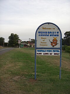
Thorpdale is a small country town in the Gippsland area of eastern Victoria, Australia, less than 20 km south of Trafalgar. Famous for its potatoes, it is located amongst the rich farmland of the Latrobe Valley. Thorpdale spuds are eaten around the country and also exported overseas. The name "Thorpdale" means "village in a valley". The soil in the area is particularly rich as the town is located in a former volcanic crater. It is administered by the Shire of Baw Baw. At the 2006 census, Thorpdale and the surrounding area had a population of 447.
West Gippsland, a region of Gippsland in Victoria, Australia, extends from the southeastern limits of metropolitan Melbourne and Western Port Bay in the west to the Latrobe Valley in the east, and is bounded by the Strzelecki Ranges to the south and the Mount Baw Baw Plateau in the Great Dividing Range to the north.

The former Victorian Railways, the state railway authority in Victoria, Australia, built a number of experimental 2 ft 6 in narrow-gauge lines around the beginning of the 20th century. Although all were closed by the early 1960s, parts of two have been reopened as heritage railways.
Erica was a railway station on the Walhalla narrow gauge line in Gippsland, Victoria, Australia. The station was officially opened in 1910, became the terminus of the line on 4 October 1952 with the closure of the section of track to Platina, then closed finally on 25 June 1954.
O'Shea and Bennett's Siding was a railway siding on the Walhalla narrow gauge line in Gippsland, Victoria, Australia, named for the local sawmill company of William O'Shea and David Bennett. The siding opened in 1921. Located at the down end in a dead end was the White Rock Lime Company's original siding, later moved to Platina. It closed in 1941 under the name Ezard's Siding, the name having been changed after the purchase of O'Shea and Bennett's sawmills by James Ezard in 1931.
The Tyers Valley Tramway was a 2 ft 6 in narrow gauge timber tramway built by the Forests Commission of Victoria to exploit timber resources on the slopes of Mount Baw Baw, Victoria. At Collins Siding the tramway linked with the Victorian Railways narrow gauge line from Moe to Walhalla, and was built to the same 2 ft 6 in gauge.

Toongabbie is a small country town located in southeastern Victoria Australia, 177 kilometres (110 mi) from Melbourne and just north of Traralgon. The railway station was closed in 1986 and the former railway line has now been incorporated into the Gippsland Plains Rail Trail. At the 2016 census, Toongabbie had a population of 500.
Willow Grove is a village and rural farming community located in the Baw Baw foothills. It is northwest of Moe in Victoria, Australia and North of Trafalgar. It has a primary school, football club, tennis courts, community hall, general store, CFA shed, and kindergarten. It is a popular tourist destination where people can enjoy trail bike riding, camping, four wheel driving & hunting. The next town to the west is Hill End and to the east Tanjil South. Willow Grove is situated within the Shire of Baw Baw and shares the postcode 3825. At the 2006 census, Willow Grove and the surrounding area had a population of 221.

The Shire of Narracan was a local government area about 120 kilometres (75 mi) east-southeast of Melbourne, the state capital of Victoria, Australia. The shire covered an area of 2,300 square kilometres (888.0 sq mi) and existed from 1878 until 1994.

The Walhalla Goldfields Rail Trail is a 7 kilometre rail trail which follows the former route of the narrow gauge Walhalla railway line between Erica and Thomson station, near Walhalla in Victoria's east. Another small section of the former line, where it runs through Moondarra State Park between Moe and Erica, is also open as the unofficial Moondarra Rail Trail.
Coopers Creek is a former township and mine in the Gippsland region of Victoria, Australia. In the 1860s, Coopers Creek was settled during the Victorian gold rush and, throughout its history, gold, copper and lime have been mined there. Today, Coopers Creek is effectively limited to two camping sites, the first near the site of the mining town and the second to the east at Bruntons Bridge. Ruins from the town's mining history, and the Copper Mine Hotel are all of the town's history which survives.

