Coopers Creek, Victoria

Last updated

Coopers Creek
Victoria
Australia Victoria Shire of Baw Baw location map.svg
Red pog.svg
Coopers Creek
Coordinates 37°58′53″S146°25′27″E / 37.9814°S 146.4243°E / -37.9814; 146.4243 Coordinates: 37°58′53″S146°25′27″E / 37.9814°S 146.4243°E / -37.9814; 146.4243
Established1860s
Postcode(s) 3825
Elevation210 m (689 ft)
Location
  • 4 km (2 mi) east-southeast of Erica
  • 5 km (3 mi) south-southwest of Walhalla
  • 25 km (16 mi) northwest of Traralgon
  • 130 km (81 mi) east-southeast of Melbourne
LGA(s) Shire of Baw Baw
State electorate(s) Narracan
Federal division(s) Monash

Coopers Creek is a locality and mine in the Gippsland region of Victoria, Australia. In the 1860s, Coopers Creek was settled during the Victorian gold rush and, throughout its history, gold, copper and lime have been mined there. Today, Coopers Creek is effectively limited to two camping sites, the first near the site of the mining town and the second to the east at Bruntons Bridge. Ruins from the locality's mining history, and the Copper Mine Hotel are all of the locality's history which survives. In August 2022, the 21 properties that comprise the town were listed for sale.

Contents

Geography

Coopers Creek is in the Shire of Baw Baw in Victoria's Gippsland region. It is located in the Great Dividing Range, in the steep forested slopes of the Thomson River valley. The original township was located around the confluence of the Thomson River and Coopers Creek which is where mining operations were centred. The area gazetted as Coopers Creek is partially bounded by the Thomson River and by a number of roads in the area. It is partially within the Baw Baw National Park, the Erica State Forest and the Boola Boola State Forest. The area used for mining is now included in the Coopers Creek Copper Mine Historic and Cultural Features Reserve. [1] [2] [3]

History of industry

Mining

Alluvial gold from a copper, silver, gold and platinum deposit in the area [4] was found in the Thomson River upstream of Coopers Creek resulted in a number of mining claims being made in the area during the Victorian gold rush. However, very little gold was actually discovered in Coopers Creek. It was the discovery of the first copper deposit in Victoria, in 1864, which led to the continued viability of township. [5] Initial smelting conducted in Coopers Creek was unsuccessful and unprofitable due to lowered copper prices and the large quantity of firewood being consumed in the process. [6]

A new source of copper was found in 1878 and led to the significant increase in mining infrastructure, including a new crushing mill, kilns and smelting furnaces, and an increase to 70 men being employed at the mine. By 1880, however, the copper found two years earlier had been exhausted and the mine fell into relative disuse for twenty to thirty years. [6] The post office, opened twenty-five years earlier, closed on 11 September 1893. [7]

Though attempts were made to begin mining at Coopers Creek in the late 1800s, it was not until 1910 that large-scale mining began again. Earlier wishes that the train line from Moe to Erica, around 8 kilometres (5.0 mi) by rail to the east, be extended to Coopers Creek were realised around 1910, with the Platina station on the Walhalla railway line being constructed at Coopers Creek. New leases were taken up by the Gippsland Copper and Platinum Mining and Smelting Company in around 1910 with the intention to bring new technology and increase the mining of copper at Coopers Creek. [6] [8]

The last gold mined from Happy-Go-Lucky was sold to the copper smelting works at Coopers Creek before its closure in 1915. The Walhalla mine closed around the same time. Operations at Coopers Creek ceased in 1915 following the pattern of mine closures in the area. [6]

Mining operations returned to Coopers Creek in the 1960s, with the copper mine being cleared out and building of a new smelter being completed in 1969. The renewed mining operation was short lived, however, ending in 1971 due to the falling price of copper. [6] The Long Tunnel Extended Mine at Walhalla was opened for tourism some years later, and a number of pieces of equipment and buildings were moved there from Coopers Creek. [6]

Other industries

Following the collapse of the copper mining industry in the 1910s, lime instead became the main industry at Coopers Creek. There was a lime quarry, underground mine and kilns near the township in the late 1920s. Around this time accommodation in Coopers Creek consisted of four cottages, a bunk house and tents. [5] Despite the closure of Walhalla's largest gold mine in the 1910s, the lime exports from Coopers Creek meant that the Walhalla railway line continued to operate regularly following a significant decline in rail traffic through the 1930s. [9] Lime quarrying continued in Coopers Creek until 1952 when the last quarry closed. [5]

Woodcutting had also been a major industry in the Coopers Creek area, mainly to support the mining operations by providing firewood and construction materials. This tree felling had a significant impact on the area, however, as, by the 1930s, there was such a shortage of trees that they needed to be felled in adjacent valleys. [5] The 1939 Black Friday bushfires further devastated the Coopers Creek area and forced a large part of the population to move into larger towns and cities to seek employment. [5]

Township

The township of Coopers Creek was established in the 1860s around the copper mine and smelting works located around the confluence of the Thomson River and Coopers Creek and was described as having "a lively appearance" and that it had potential to become "a flourishing little place". [6] [5] The Copper Mine Hotel began operations during the 1860s to support the growing population with both accommodation and as a pub. [1] The population of Coopers Creek was large enough, that, on 1 January 1868 a post office was opened in the town. [7]

Around 1952, the Copper Mine Hotel ( 37°59′05″S146°25′27″E / 37.9846°S 146.4243°E / -37.9846; 146.4243 (Copper Mine Hotel, Coopers Creek) ) closed after around 100 years of operation from various locations around the township. The final building, apparently the only one left standing, became derelict and burnt down in 1999, leaving the original chimneys. It has since been rebuilt, maintaining its original design, but was closed to the public in 2007 and also includes a private two-bedroom residence. [1] [5] [10] [11]

In 2015, Coopers Creek consisted only of two campsites in addition to the unused pub buildings, the first near the location of the original township and mine and the second to the east of the original township at Bruntons Bridge. The Coopers Creek campsite is a popular camping site and includes a long drop toilet, picnic tables, a boat ramp as well as walking and four-wheel drive tracks. Ruins from the locality's mining history can also be found around the camping sites. [1] [12] [2] [13] [14]

From around 1960 the Holyoak family, after staying at the Copper Mine Hotel, began purchasing titles of properties in the town. By 2022 the family had acquired all 21 property titles in the town which including the pub as well as open parkland. That year they listed for sale the 4.45 hectares (11.0 acres) of the town for between A$2,500,000 and A$3,000,000 with comparisons being made by Australian media to Canadian television sitcom Schitt's Creek . [10] [15] [16]

Related Research Articles

<span class="mw-page-title-main">Gippsland</span> Region in Victoria, Australia

Gippsland is a rural region that makes up the southeastern part of Victoria, Australia, mostly comprising the coastal plains to the rainward (southern) side of the Victorian Alps. It covers an elongated area of 41,556 km2 (16,045 sq mi) located further east of the Shire of Cardinia between Dandenong Ranges and Mornington Peninsula, and is bounded to the north by the mountain ranges and plateaus/highlands of the High Country, to the southwest by the Western Port Bay, to the south and east by the Bass Strait and the Tasman Sea, and to the east and northeast by the Black-Allan Line.

<span class="mw-page-title-main">Shire of Baw Baw</span> Local government area in Victoria, Australia

The Shire of Baw Baw is a local government area in Victoria, Australia, in the eastern part of the state. It covers an area of 4,028 square kilometres (1,555 sq mi) and in June 2018 had a population of 52,015.

<span class="mw-page-title-main">Mount Baw Baw</span> Mountain in Victoria, Australia

Mount Baw Baw is a mountain summit on the Baw-Baw Plateau of the Great Dividing Range, located in Victoria, Australia. The name is from the Woiwurrung language spoken by Eastern Kulin people. It is of uncertain meaning, but possibly signifies, echo, or ghost.

<span class="mw-page-title-main">Walhalla, Victoria</span> Town in Victoria, Australia

Walhalla is a town in Victoria, Australia, founded as a gold-mining community in late 1862, and at its peak, home to around 4,000 residents. As of 2016, the town has a population of 35 permanent residents, though it has a large proportion of houses owned as holiday properties. It attracts large numbers of tourists and is a major focus of the regional tourism industry. The town's name is taken from an early gold mine in the area, named for the German hall of fame, the Walhalla temple.

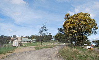
Pearson was a town in Victoria, Australia, located 1+12 miles southwest of Walhalla. It was in the local government area of the Shire of Baw Baw. It was also known as The Happy, and Happy Go Lucky.

<span class="mw-page-title-main">Matlock, Victoria</span> Town in Victoria, Australia

Matlock is a rural locality in Victoria, Australia, located about 140 kilometres north-east of Melbourne, located within the Shires of Mansfield and Yarra Ranges local government areas. Matlock recorded a population of 7 at the 2021 census.

<span class="mw-page-title-main">Walhalla Goldfields Railway</span> Narrow gauge tourist railway in Victoria, Australia

The Walhalla Goldfields Railway is a 2 ft 6 in narrow gauge tourist railway located in the Thomson River and Stringers Creek valleys in Gippsland, Victoria, Australia, near the former gold-mining town and tourist destination of Walhalla.

<span class="mw-page-title-main">Walhalla railway line</span> Former railway line in Victoria, Australia

The Walhalla railway line was a 2 ft 6 in narrow gauge railway located in Gippsland, Victoria, Australia. The line ran from Moe to the former gold-mining town and popular tourist destination of Walhalla. Construction began in 1904. The line closed in sections from 1944 to 1954.

<span class="mw-page-title-main">Thomson River (Victoria)</span> River in Victoria, Australia

The Thomson River, a perennial river of the West Gippsland catchment, is located in the Gippsland region of the Australian state of Victoria.

West Gippsland, a region of Gippsland in Victoria, Australia, extends from the southeastern limits of metropolitan Melbourne and Western Port Bay in the west to the Latrobe Valley in the east, and is bounded by the Strzelecki Ranges to the south and the Mount Baw Baw Plateau in the Great Dividing Range to the north.

O'Shea and Bennett's Siding was a railway siding on the Walhalla narrow gauge line in Gippsland, Victoria, Australia, named for the local sawmill company of William O'Shea and David Bennett. The siding opened in 1921. Located at the down end in a dead end was the White Rock Lime Company's original siding, later moved to Platina. It closed in 1941 under the name Ezard's Siding, the name having been changed after the purchase of O'Shea and Bennett's sawmills by James Ezard in 1931.

Toongabbie is a town located in the City of Latrobe and Shire of Baw Baw, Victoria, Australia, 177 kilometres (110 mi) from Melbourne and just north of Traralgon. The railway station was closed in 1986 and the former railway line has now been incorporated into the Gippsland Plains Rail Trail. At the 2016 census, Toongabbie had a population of 500.

<span class="mw-page-title-main">County of Tanjil</span> Cadastral in Victoria, Australia

The County of Tanjil is one of the 37 counties of Victoria which are part of the cadastral divisions of Australia, used for land titles. It includes the coastal area around the Gippsland Lakes. The Mitchell River is the north-eastern boundary. Before the 1860s, the area was part of the former county of Bruce and part of Haddington.

The Thomson River Diversion Tunnel, also known as the Horseshoe Bend Tunnel or the Chinese Tunnel, is located on the Thomson River near the junction with Coopers Creek, approximately 4 kilometres (2.5 mi) south-west of Walhalla, Victoria, Australia. The site is listed on the Victorian Heritage Register and covered by a Heritage Overlay.

The Jordan River, a perennial river of the West Gippsland catchment, is located in the Alpine region of the Australian state of Victoria.

Burraga is located in the Central Tablelands of New South Wales, 47 kilometres south west of Oberon and about 67 kilometres (42 mi) south of Bathurst. It is within Oberon Shire. At the 2016 census, Burraga had a population of 91.

Frederick Charles Porter (1832–1869) was an Australian miner and explorer of the Gippsland region of Victoria. His exploration work in early 1862 was critical in helping open up the Jordan goldfields.

James Frederick Porter (1855-1919) was an Australian engineer and mine manager of the Gippsland region of Victoria.

<span class="mw-page-title-main">Adolphus William Copper Smelter</span> Historic site in Queensland, Australia

Adolphus William Copper Smelter is a heritage-listed former copper smelter and associated mining camp at Westwood and Oakey Creek in Rockhampton Region, Queensland, Australia. It was built in 1874. It was added to the Queensland Heritage Register on 13 May 2011.

<span class="mw-page-title-main">Mount Elliott Mining Complex</span> Historic site in Queensland, Australia

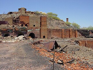
Mount Elliott Mining Complex is a heritage-listed copper mine and smelter at Selwyn, Shire of Cloncurry, Queensland, Australia. It was designed by William Henry Corbould and built in 1908. It is also known as Mount Elliott Smelter and Selwyn. It was added to the Queensland Heritage Register on 16 September 2011.

References

  1. 1 2 3 4 Shire of Baw Baw. "Visit Baw Baw – Coopers Creek" . Retrieved 30 December 2017.
  2. 1 2 Explore Australia. "Coopers Creek camping area, Boola Boola State Forest- Explore Australia". Explore Australia Publishing. Archived from the original on 31 December 2017. Retrieved 30 December 2017.
  3. "VICNAMES – The Register of Geographic Names". Land Channel (Department of Environment, Land, Water and Planning). Victorian Government. Retrieved 31 December 2017.
  4. Minerals Council of Australia – Victorian Division. "Cooper – Cu" (PDF). Archived from the original (PDF) on 21 March 2018. Retrieved 30 December 2017.
  5. 1 2 3 4 5 6 7 Grollo, Diana Ruzzene (2004). "Coopers Creek Gippsland: The Trevisani" (PDF). Italian Historical Society Journal: 17–24. Archived from the original (PDF) on 13 March 2018. Retrieved 30 December 2017.
  6. 1 2 3 4 5 6 7 Heritage Council of Victoria (December 2012). "Victorian Heritage Database Report" (PDF). Retrieved 30 December 2017.
  7. 1 2 "Post Office List – PPA". Phoenix Auctions Auctions. Retrieved 28 February 2021.
  8. "1 – Mining and Company Files – Minerals Separation Ltd Guide to Records". Australian Science and Technology Heritage Centre . University of Melbourne . Retrieved 30 December 2017.
  9. Newnham, Ian (September 2016). Walhalla Goldfields Railway (PDF). Gippsland Regional Group, Engineers Australia . Retrieved 30 December 2017.
  10. 1 2 Mim Hook and Ian Mason (5 August 2022). The town Coopers Creek is for sale (radio broadcast). ABC Gippsland . Retrieved 5 February 2023.
  11. "Former Copper mine Hotel in Coopers Creek". Australia Gday Pty Ltd. Retrieved 31 December 2017.
  12. "Victorian Free Camping: Coopers Creek Camp Ground". Victorian Free Camping. Retrieved 30 December 2017.
  13. Explore Australia. "Bruntons Bridge camping area, Boola Boola State Forest- Explore Australia". Explore Australia Publishing. Archived from the original on 31 December 2017. Retrieved 30 December 2017.
  14. Walhalla & Mountain Rivers Tourism Inc. (2015). "Walhalla Visitor Guide" (PDF). Walhalla, Victoria. Retrieved 31 December 2017.
  15. "1 Coopers Creek Road, Coopers Creek, Vic 3825". realestate.com.au. REA Group . Retrieved 5 February 2023.
  16. Power, Emily. "Australia's own Schitt's Creek for sale". Nine News . Nine Network . Retrieved 5 February 2023.