
Warragul is a town in Victoria, Australia, 102 kilometres south-east of Melbourne. Warragul lies between the Strzelecki Ranges to the south and the Mount Baw Baw Plateau of the Great Dividing Range to the north. As at the 2021 census, the town had a population of 19,857 people. Warragul forms part of a larger urban area that includes nearby Drouin that had an estimated total population of 37,928 at June 2018.
Noojee is a town in the Gippsland region of Victoria, Australia, north of Warragul and east of Melbourne, in the Baw Baw local government area. At the 2016 census, Noojee and the surrounding area had a population of 157. The town benefits from tourists passing through to the Mount Baw Baw Alpine Resort, 48 kilometres away, as it is the last stop with tourism services. There are also a number of walks in the area, including the Noojee Trestle Bridge, a 100m wooden rail bridge.

Drouin is a town in the West Gippsland region, 90 kilometres (56 mi) east of Melbourne, in the Australian state of Victoria. Its local government area is the Shire of Baw Baw, and is home to the shire council’s headquarters despite being the second-largest town in the shire, behind neighbouring Warragul. The town’s name is believed to be an Aboriginal word meaning "north wind". New housing developments have accelerated the town's residential growth in recent years. As at the 2016 census, Drouin had a population of 11,887 people.

Yarragon is a small town in the Baw Baw Shire in the West Gippsland region of Victoria, Australia. The town lies on the Princes Highway and the main Gippsland Railway line approximately halfway between the major towns of Warragul and Moe. Hills of the Strzelecki Ranges rise over 500 metres immediately to the south of the town providing a spectacular backdrop, while the Moe River and the lowlands lie to the north and east. Mount Worth at 515m above sea level is the highest near peak to the south in the Mount Worth State Park 16 kilometres SSW of Yarragon. Mount Baw Baw at 1563m in the Baw Baw Ranges as part of the Great Dividing Range to the north is approximately 85 kilometres NNE of Yarragon. The township sits at approximately 88 metres above sea level. At the 2006 census, Yarragon had a population of 1131.
Icy Creek is a locality in Victoria, Australia, located on Mount Baw Baw Road, in the Shire of Baw Baw.
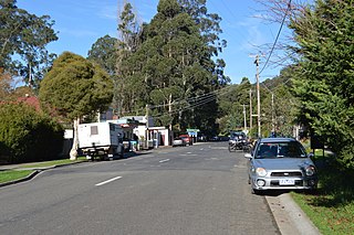
Tanjil Bren is a town in Victoria, Australia, on Mount Baw Baw Tourist Road, 12 kilometres (7 mi) west of Mount Baw Baw in the Shire of Baw Baw. It was established during the Victorian Gold Rush. Four accommodation lodges, Mooshead, Reindeer, Jenny's and Timbertop Lodge, are located in Tanjil Bren. At the 2006 census, Tanjil Bren and the surrounding area had a population of 110.

Neerim is a locality in Victoria, Australia, on Main Neerim Road in the Shire of Baw Baw.

Neerim South is a town in West Gippsland, Victoria, Australia, located in the Shire of Baw Baw, 109 kilometres (68 mi) east of Melbourne and 19 kilometres (12 mi) north of Warragul. At the 2016 census, Neerim South had a population of 1,305.
Neerim North is a town in Victoria, Australia, located on Neerim North Road, in the Shire of Baw Baw.
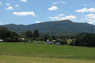
Fumina South is a locality in Victoria, Australia. Located on Willowgrove Road, in the Shire of Baw Baw, it is an isolated pocket near the foothills of Mount Baw Baw. Fumina South has a population of approximately 50 people, mostly weekend farmers and retirees, although it was once a bustling community with its own post office and school.
Rawson is a town in Victoria, Australia, located on Tyers - Thomson Valley Road, in the Shire of Baw Baw. The town was established for workers involved in the construction of the Thomson Dam, which was completed in 1983, Rawson Post Office opening on 17 April 1979.

Parkers Corner is a town in Victoria, Australia, located at the junction of Rawson Road and Tyers - Thomson Valley Road, in the Shire of Baw Baw. With only 12 residents, it is the third-smallest town in Victoria.

Erica is a town in Victoria, Australia, on Rawson Road, in the Shire of Baw Baw.
Darnum is a town in West Gippsland, Victoria, Australia, located 110 km east of Melbourne and a short distance to Warragul, in the Shire of Baw Baw. It is nestled between the Great Dividing Range and Strzelecki Ranges. The Moe River meanders through the edge of the township which the historic Darnum Butter Factory overlooks.

Longwarry is a town in Victoria, Australia, 83 kilometres (52 mi) south-east of Melbourne's Central Business District, located within the Shires of Baw Baw and Cardinia local government areas. Longwarry recorded a population of 2,436 at the 2021 census.
Jindivick is a town in Victoria, Australia, located on Jacksons Track, in the Shire of Baw Baw.

Modella is a locality in Victoria, Australia, 77 kilometres (48 mi) south-east of Melbourne's central business district, located within the Shires of Baw Baw and Cardinia local government areas. Modella recorded a population of 169 at the 2021 census.
Toorongo is a bounded rural locality in Victoria, Australia, located within the Shires of Baw Baw and Yarra Ranges local government areas. Toorongo recorded no population at the 2021 census.
Heath Hill is a locality in Victoria, Australia, 79 kilometres (49 mi) south-east of Melbourne's Central Business District, located within the Shires of Baw Baw and Cardinia local government areas. Heath Hill recorded a population of 189 at the 2021 census.
Labertouche is a locality in Victoria, Australia, located on Jacksons Track, in the Shire of Baw Baw. At the 2016 census, Labertouche had a population of 356.
