Lancefield railway line

Last updated

Lancefield
Overview
StatusNow operating as the Old Railway Station B & B and Carriage Cafe.
Former connectionsJoined Bendigo mainline at Clarkefield, and Heathcote line (now closed) at Kilmore.
Stations12?
Service
TypeV/Line passenger service
History
Opened6 June 1881 to Lancefield,
extended to Kilmore 6 April 1892.
Completed1892 to Kilmore.
Closed1 June 1897 beyond Lancefield,
remainder closed 13 August 1956
Technical
Number of tracks Single
Lancefield railway line
(Clarkefield – Kilmore, via Lancefield)
BSicon BHFq.svg
BSicon eABZq+r.svg
BSicon exSTR.svg
at Clarkefield
BSicon exHST.svg
Bolinda
BSicon exHST.svg
Monegetta
BSicon exHST.svg
North Monegetta
BSicon exHST.svg
Romsey
BSicon exHST.svg
Tickawarra siding
BSicon exHST.svg
Lancefield racecourse
BSicon exHST.svg
Lancefield
BSicon exHST.svg
Macedonia hotel platform
BSicon exHST.svg
Mount William
BSicon exHST.svg
Goldie
BSicon exHST.svg
Springfield
BSicon exHST.svg
High Park
BSicon exHST.svg
Forbes
BSicon exBHFq.svg
BSicon eABZqr.svg
Kilmore
The old trestle bridge on the former railway near Clarkefield Lancefield railway trestle bridge.JPG
The old trestle bridge on the former railway near Clarkefield
The former Lancefield railway station Former Lancefield station, winter 2009.JPG
The former Lancefield railway station

The Lancefield railway line, or the Clarkefield and Lancefield Railway, was a former broad gauge railway in central Victoria, connecting Clarkefield railway station on the Bendigo line to Kilmore railway station on the Heathcote line, via Lancefield. However, the ill-fated Lancefield-Kilmore section operated only briefly in the 1890s so, for much of its history, the line existed simply as a branch line, with its terminus at Lancefield station.

Contents

History

Clarkefield-Lancefield section

The branch line off the Melbourne-Bendigo line originated at Clarkefield, then known as Lancefield Junction, and ran to Bolinda, Monegeetta, North Monegeetta, Romsey and Lancefield, [1] and was opened on 6 June 1881. [2]

The Lancefield-Clarkefield section of the branch was closed on 13 August 1956, [2] when the wooden trestle bridge near Clarkefield required extensive maintenance and repairs. Though the railway right of way no longer exists, the former track bed can still be seen in many places, most notably the embankments and cuttings leading onto the decaying trestle bridge, which are visible from the road-side at the Bolinda bridge. The old Lancefield railway station fell into a state of disrepair after its closure but has since been refurbished as the Old Railway Station B & B and Carriage Cafe.

The station building and goods shed from Monegeeta were relocated to a farming property just north of Romsey, on Lancefield Road, where they remain today as farm outbuildings. None of the other stations remain intact. The sites of Bolinda and North Monegeeta stations and, to a lesser extent, those of Monegeeta and Romsey, are still identifiable.

Lancefield-Kilmore section

On 6 April 1892, the line was extended from Lancefield across the Great Dividing Range to Kilmore. [3] This was one of the most infamous white elephants among the many late-nineteenth century Victorian rail projects, on a par with the Outer Circle railway line in suburban Melbourne.

Due to the steepness of the topography, not only was the Lancefield-Kilmore railway meandering and expensive to construct, it also ran through almost uninhabited country and, with little or no passenger custom or freight demand. The line was so unsuccessful that it was closed on 1 June 1897, [4] although the tracks were not torn up until 1917. Some of the old right of way is visible around the Lancefield Gap and on the approach to Kilmore.

For such a relatively short section of railway, the line had a significant number of stations or, at least, named stopping places. From Lancefield to Kilmore, stopping places included Mount William, Goldie, Springfield, High Park and Forbes [5] [6]

Related Research Articles

<span class="mw-page-title-main">Sunbury, Victoria</span> Suburb of City of Hume, Victoria, Australia

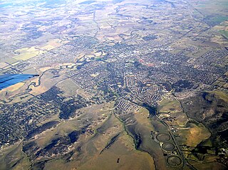
Sunbury is a suburb in Melbourne, Victoria, Australia, 36 kilometres (22 mi) north-west of Melbourne's Central Business District, located within the City of Hume local government area. Sunbury recorded a population of 38,851 at the 2021 census.

<span class="mw-page-title-main">Sunbury railway station, Melbourne</span> Railway station in Melbourne, Australia

Sunbury railway station is the terminus of the suburban electrified Sunbury line in Victoria, Australia. It serves the north-western Melbourne suburb of Sunbury, and opened on 10 February 1859.

<span class="mw-page-title-main">Clarkefield railway station</span> Railway station in Victoria, Australia

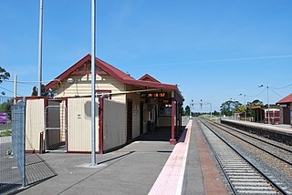
Clarkefield railway station is located on the Deniliquin line in Victoria, Australia. It serves the town of Clarkefield, and it opened in December 1862 as Lancefield Road. It was renamed Lancefield Junction in 1881, renamed Clarkfield on 11 January 1926, and renamed Clarkefield on 23 February 1926.

<span class="mw-page-title-main">Riddells Creek railway station</span> Railway station in Victoria, Australia

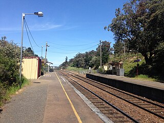
Riddells Creek railway station is located on the Deniliquin line in Victoria, Australia. It serves the town of Riddells Creek, and it opened on 8 July 1861. It was renamed Riddell on 9 May 1904, and was renamed Riddells Creek on 12 October 1976.

<span class="mw-page-title-main">Gisborne railway station</span> Railway station in Victoria, Australia

Gisborne railway station is located on the Deniliquin line in Victoria, Australia. It serves the town of New Gisborne, and it opened on 8 July 1861.

<span class="mw-page-title-main">Kilmore, Victoria</span> Town in Victoria, Australia

Kilmore is a town in the Australian state of Victoria. Located 65 kilometres (40 mi) north of Melbourne, it is the oldest inland town in Victoria by the combination of age and physical occupation, and because it had unique agricultural attributes to drive that earliest settlement. It grew very rapidly to become four times bigger than its nearest inland rival by 1851. Its spectacular growth continued to match that of the major gold mining towns of Ballarat, Bendigo and Beechworth until at least 1861.

<span class="mw-page-title-main">Heathcote Junction railway station</span> Railway station in Victoria, Australia

Heathcote Junction railway station is located on the North East line in Victoria, Australia. It serves the town of Heathcote Junction, and opened on 17 March 1890 as Kilmore Junction. It was renamed Heathcote Junction on 15 May 1922.

The North East railway line is a railway line in Victoria, Australia. The line runs from Albury railway station in the border settlement of Albury–Wodonga to Southern Cross railway station on the western edge of the Melbourne central business district, serving the cities of Wangaratta and Seymour, and smaller towns in northeastern Victoria. The line is owned by VicTrack, but leased to, and maintained by, the Australian Rail Track Corporation, and forms part of the Sydney–Melbourne rail corridor.

<span class="mw-page-title-main">Piangil railway line</span> Partially closed railway line in Victoria, Australia

The Piangil railway line is a 5 ft 3 in gauge (1600 mm) railway line in north-western Victoria, Australia. It branches off the Deniliquin line just north of Bendigo, and runs in a north-westerly direction through Pyramid Hill and Kerang to the border town of Swan Hill, then roughly parallels the New South Wales border to Piangil and Yungera. The line is now open only as far as Piangil, and passenger services only operate to Swan Hill.

The Deniliquin railway line is a broad-gauge railway line serving northwestern Victoria, Australia. The line runs from the border settlement of Deniliquin into Bendigo, before turning south-southeast towards Melbourne, terminating in Docklands near the central business district. It is a major trunk line both for passenger and freight trains, with many railway lines branching off from it.

<span class="mw-page-title-main">Lancefield, Victoria</span> Town in Victoria, Australia

Lancefield is a town in the Shire of Macedon Ranges local government area in Victoria, Australia 69 kilometres (43 mi) north of the state capital, Melbourne and had a population of 2,743 at the 2021 census.

<span class="mw-page-title-main">Clarkefield, Victoria</span> Town in Victoria, Australia

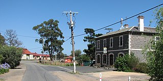
Clarkefield is a town in Victoria, Australia, 41 kilometres (25 mi) north-west of Melbourne's Central Business District, located within the City of Hume and the Shire of Macedon Ranges local government areas. Clarkefield recorded a population of 303 at the 2021 census.

<span class="mw-page-title-main">Monegeetta, Victoria</span> Town in Victoria, Australia

Monegeetta is a town north of Melbourne, Australia between the major towns of Sunbury and Romsey in fertile agricultural land east of the Macedon Ranges. Its local government area is the Shire of Macedon Ranges.

<span class="mw-page-title-main">Shire of Romsey</span> Local government area in Victoria, Australia

The Shire of Romsey was a local government area about 65 kilometres (40 mi) north-north-west of Melbourne, the state capital of Victoria, Australia. The shire covered an area of 628 square kilometres (242.5 sq mi), and existed from 1862 until 1995.

<span class="mw-page-title-main">Bolinda, Victoria</span> Town in Victoria, Australia

Bolinda is a locality north of Melbourne, Australia on the Melbourne-Lancefield Road. It is 6 km. south of Romsey, within the Shire of Macedon Ranges.

<span class="mw-page-title-main">Springfield, Victoria (Macedon Ranges)</span> Town in Victoria, Australia

Springfield is a locality in the Shire of Macedon Ranges local government area in central Victoria, Australia approximately 65 kilometres north of the state capital, Melbourne. It is within the catchment area of Deep Creek, a tributary of the Maribyrnong River.

The Heathcote railway line was a cross-country link between Bendigo and Heathcote Junction. It was partly opened in 1888 and, by 1890, it was fully operational. It was partially closed in 1958 and fully closed in 1968.

Kilmore railway station was a railway station servicing the town of Kilmore, Victoria, Australia. It was located on Rutledge Street, Kilmore, to the east of Assumption College.

References

  1. Railway Map of Victoria, Australia, 1946 map reproduced courtesy V/Line, Railway Museum, North Williamstown, Victoria, 1988
  2. 1 2 Mitchell, Peter; Alan Jackson; Carol Moore; Gavin Smith (2004). Romsey: A Veritable Garden of Eden. Romsey: West Bourke Books Inc. ISBN   0-646-43570-1.
  3. Turton, Keith (April 1970). "The Heathcote Junction to Bendigo and Associated Railways". Australian Railway Historical Society Bulletin : 69–88.
  4. Poole, L.G. (February 1953). "Some Notes on the Lancefield-Kilmore Section". Australian Railway Historical Society Bulletin : 22–23.
  5. Victorian Municipal Directory. Brunswick: Arnall & Jackson. 1956. pp. 751–2.
  6. "Railway Map of Victoria, 1900" (PDF). Victorian Railway Maps 1860 – 2000. Victorian Railways Resources. Retrieved 20 June 2010.