Related Research Articles

The Shire of Yarriambiack is a local government area of Victoria, Australia, located in the north-western part of the state. It covers an area of 7,326 square kilometres (2,829 sq mi) and, in June 2018, had a population of 6,658, having fallen from 7,438 in 2008. It includes the towns of Hopetoun, Murtoa, Rupanyup and Warracknabeal. It was formed in 1995 from the amalgamation of the Shire of Warracknabeal, Shire of Karkarooc, and parts of the Shire of Dunmunkle and Shire of Wimmera.
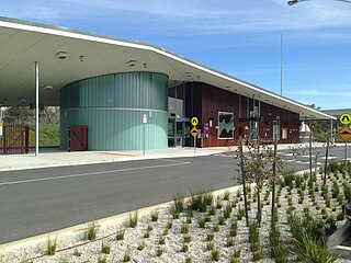
Wodonga railway station is located on the North East line in Victoria, Australia. It serves the city of Wodonga, and it opened on 25 June 2011.

Murtoa is a wheat district town in Victoria, Australia, situated around Lake Marma on the Wimmera Highway, 305 kilometres (190 mi) north-west of the state capital, Melbourne. The town is in the Shire of Yarriambiack local government area. At the 2016 census, Murtoa had a population of 865 and is located around 30 kilometres from Horsham, a major city in the Wimmera region.
The Serviceton railway line is part of the Melbourne–Adelaide rail corridor. It serves the west of Victoria, linking the state capital of Melbourne to the cities of Ballarat and Ararat. It once extended to the disputed South Australian border as part of the Melbourne–Adelaide railway. The former broad-gauge track was replaced in 1995 by the 1435 mm Western standard gauge line.
Kilmore East railway station is located on the North East line in Victoria, Australia. It serves the town of Kilmore East, and opened on 18 April 1872 as Kilmore. It was renamed Kilmore East on 1 October 1888.

Tallarook railway station is located on the North East line in Victoria, Australia. It serves the town of Tallarook, and it opened on 18 April 1872.

Wangaratta railway station is located on the North East line in Victoria, Australia. It serves the town of Wangaratta, and it opened on 28 October 1873.

Beulah is a town in the southern Mallee region of Victoria, Australia. The town is in the Shire of Yarriambiack local government area, 395 kilometres north-west of the state capital, Melbourne. At the 2016 census, Beulah had a population of 329.
The Western standard gauge railway line is a standard-gauge railway line in western Victoria, Australia. Completed in 1995, it forms part of the Melbourne–Adelaide rail corridor and serves as the principal interstate rail link between Victoria and the western states. The line replaced a number of former broad gauge routes which were gauge converted, and today sees both intrastate and interstate freight traffic, as well as the twice weekly The Overland passenger service. Major towns on the route include Geelong, Ararat, Horsham and Dimboola.

The Shire of Karkarooc was a local government area in northwestern Victoria, Australia. The shire covered an area of 3,719 square kilometres (1,435.9 sq mi), and existed from 1896 until 1995.
The Portland railway line is a railway line in south-western Victoria, Australia. It runs from the main Western standard gauge line at Maroona through Hamilton to the port town of Portland.

Hamilton is a railway station located on the Ararat - Portland railway in the town of Hamilton, Victoria, Australia. Today the station is now used only for through trains, and the large station building is used only to serve bus passengers, although the disused platform remains in reasonable condition.

Brim is a small town in the Wimmera region of Victoria, Australia. The town is located 359 kilometres (223 mi) north west of the state capital, Melbourne on the Henty Highway. It is on the banks of the Yarriambiack Creek. It is in the Shire of Yarriambiack local government area. At the 2016 census, Brim had a population of 171.

Roxburgh Park railway station is located on the Craigieburn line in Victoria, Australia. It serves the northern Melbourne suburb of Roxburgh Park, and opened on 21 September 2007.
Aubrey is a locality west of Warracknabeal in Victoria.

The Carpolac Railway Line was a railway line located in the Wimmera region of Victoria that branched off of the Serviceton railway line at Horsham railway station, Victoria. It was opened from Horsham to East Natimuk in August 1887, East Natimuk to Goroke in July 1894 and then from Goroke to Carpolac in May 1927 and closed on December 8, 1986.

The Bolangum railway line was a railway line branching off of the Serviceton railway line at Lubeck. The line was opened in stages beginning with Lubeck to Rupanyup in June 1887 and eventually reached Bolangum in July 1927.
The Yaapeet railway line is a standard-gauge railway line branching off of the Serviceton railway line. The line was opened in stages beginning from Dimboola to Jeparit on June 19, 1894 and reaching Yaapeet on June 25, 1914.
The Yanac railway line was a railway line in Victoria, Australia, branching off of the Yaapeet railway line at Jeparit station. It was opened in two stages from Jeparit to Lorquon on December 10, 1912, and Lorquon to Yanac in 1916. It was closed in late 1986.
Hopetoun Railway Station was a railway station on the Patchewollock railway line. It was opened in April 1894 and closed to passengers in 1976 with the cessation of the railmotor service from Murtoa railway station. By 1956, the telegraph equipment was removed, by 1970, the turntable was removed and by 1977, the Station master was removed. The station building has since been removed, and only the Grain silos/goods shed remains.
References
- 1 2 3 "VICSIG". vicsig.net. Retrieved 2021-04-21.
- 1 2 3 Bibliophile (2013-01-20). "Wimmera...way back when: Railways - Patchewollock line". Wimmera...way back when. Retrieved 2021-04-21.
- ↑ "Patchewollock Line". www.vicrailstations.com. Retrieved 2021-04-21.
| |||||||||||||||||||
| |||||||||||||||||||
| |||||||||||||||||||
| |||||||||||||||||||
| |||||||||||||||||||