
Princes Highway is a major road in Australia, extending from Sydney via Melbourne to Adelaide through the states of New South Wales, Victoria and South Australia. It has a length of 1,941 kilometres (1,206 mi) or 1,898 kilometres (1,179 mi) via the former alignments of the highway, although these routes are slower and connections to the bypassed sections of the original route are poor in many cases.

Sturt Highway is an Australian national highway in New South Wales, Victoria, and South Australia. It is an important road link for the transport of passengers and freight between Sydney and Adelaide and the regions along the route.

The Frankston line is a commuter railway line in the city of Melbourne, Victoria, Australia. Operated by Metro Trains Melbourne, it is the city's third longest metropolitan railway line at 42.7 kilometres (26.5 mi). The line runs from Flinders Street station in central Melbourne to Frankston station in the south-east, serving 28 stations via South Yarra, Caulfield, Moorabbin, and Mordialloc. The line continues to Stony Point on the non-electrified Stony Point line. The line operates for approximately 20 hours a day with 24 hour service available on Friday and Saturday nights. During peak hour, headways of up to 5 to 10 minutes are operated with services every 10-20 minutes during off-peak hours. Trains on the Frankston line run with a two three-car formations of Comeng, Siemens Nexas, and X'Trapolis 100 trainsets.
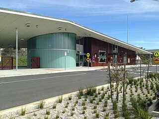
Wodonga railway station is located on the North East line in Victoria, Australia. It serves the city of Wodonga, and it opened on 25 June 2011.

The Australian state of New South Wales has an extensive network of railways, which were integral to the growth and development of the state. The vast majority of railway lines were government built and operated, but there were also several private railways, some of which operate to this day.
Murray Valley Highway is a 663-kilometre (412 mi) state highway located in Victoria and New South Wales, Australia. The popular tourist route mostly follows the southern bank of the Murray River and effectively acts as the northernmost highway in Victoria. For all but the western end's last three kilometres, the highway is allocated route B400.

The Deniliquin and Moama Railway Company was a railway company formed by a syndicate of Victorian capitalists to construct a railway from Moama to Deniliquin in New South Wales, Australia.

Kerang railway station is located on the Piangil line in Victoria, Australia. It serves the town of Kerang, and it opened on 25 October 1884.

The Piangil railway line is a 5 ft 3 in gauge (1600 mm) railway line in north-western Victoria, Australia. It branches off the Deniliquin line just north of Bendigo, and runs in a north-westerly direction through Pyramid Hill and Kerang to the border town of Swan Hill, then roughly parallels the New South Wales border to Piangil and Yungera. The line is now open only as far as Piangil, and passenger services only operate to Swan Hill.
The Deniliquin railway line is a broad-gauge railway line serving northwestern Victoria, Australia. The line runs from the border settlement of Deniliquin into Bendigo, before turning south-southeast towards Melbourne, terminating in Docklands near the central business district. It is a major trunk line both for passenger and freight trains, with many railway lines branching off from it.

Murrabit is a town in northern Victoria, Australia. It is on the Murray River, 305 kilometres (190 mi) from the state capital, Melbourne and 52 kilometres (32 mi) from Swan Hill. Murrabit is in the Shire of Gannawarra local government area and at the 2016 census, Murrabit and the surrounding area had a population of 201, declining from 330 just five years earlier.

Kyalite is a locality on the Wakool River in the Riverina district of the Australian state of New South Wales. It is part of Balranald Shire and is approximately 890 kilometres (550 mi) south west of the state capital Sydney and 400 kilometres (250 mi) north west of Melbourne. Kyalite was formerly known as Wakool Crossing. At the 2006 census, Kyalite had a population of 108.
Stony Crossing is a locality in the south western part of the Riverina on the south bank of the Wakool River. By road, it is about 22 kilometres (14 mi) south east from Kyalite and 35 kilometres (22 mi) north west from Swan Hill.

Abbotsford Bridge is a steel Allan truss-type road bridge that carries the Silver City Highway across the Murray River, between Curlwaa in New South Wales, and Yelta in Victoria, Australia. It is the only remaining steel truss bridge with a lift span that crosses the Murray. Opened in 1928, the bridge was built by the NSW Department of Public Works and was designed by Percy Allan. It was the second last vertical-lift bridge to be built over the river, the last being the Nyah Bridge, which opened in 1941.
The Robinvale railway line is a freight only country railway line in north-western Victoria, Australia. The line branches from the Mildura line at Dunolly, and at Inglewood the Eaglehawk – Inglewood line connects with the Piangil line outside Bendigo. The parallel Kulwin line junctions from the Robinvale line at Korong Vale then continues northward.
The 1922 Border Railways Acts, were Acts passed by the Parliaments of both Victoria and New South Wales, which authorised the construction of cross border railways in the Riverina region of Australia. Despite being located in New South Wales, the region was closer economically to Victoria and its railway network, operated by Victorian Railways. Another complication was that Victorian Railways used the 1,600 mm broad gauge, while the New South Wales Government Railways used 1,435 mm standard gauge.

The Bethanga Bridge is a steel truss road bridge that carries the Riverina Highway across Lake Hume, an artificial lake on the Murray River in Australia. The dual heritage-listed bridge crosses the border between the Australian states of New South Wales and Victoria, linking the Victorian towns of Bellbridge and Bethanga with the regional New South Wales city of Albury.

The George Chaffey Bridge is a road bridge in Australia that carries the Sturt Highway across the Murray River from Buronga to Mildura.
The Sydney Express was a passenger train which operated between Australia's two most populous cities, Melbourne and Sydney, between 1883 and 1937. The service commenced when the Victorian railway was extended across the Murray River to Albury to link with New South Wales' standard gauge line. The Sydney Express was superseded in 1937 by the Spirit of Progress, which also terminated at Albury until 1962, when the North East railway line was converted to standard gauge allowing it, and the new Southern Aurora to operate through to Sydney.