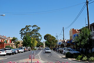
Kerang is a rural town on the Loddon River in northern Victoria in Australia. It is the commercial centre to an irrigation district based on livestock, horticulture, lucerne and grain. It is located 279 kilometres (173 mi) north-west of Melbourne on the Murray Valley Highway a few kilometres north of its intersection with the Loddon Valley Highway, elevation 78 metres (256 ft). At the 2016 census, Kerang had a population of 3,893. Kerang is believed to be an Aboriginal word for Cockatoo.

Koondrook is a town situated on the Murray River, Victoria, Australia. The town is located in the Shire of Gannawarra local government area, 301 kilometres (187 mi) north west of the state capital, Melbourne. At the 2011 census, Koondrook had a population of 769.

Murrabit is a town in northern Victoria, Australia. It is on the Murray River, 305 kilometres (190 mi) from the state capital, Melbourne and 52 kilometres (32 mi) from Swan Hill. Murrabit is in the Shire of Gannawarra local government area and at the 2016 census, Murrabit and the surrounding area had a population of 201, declining from 330 just five years earlier.
The Anglican Diocese of Bendigo is the Anglican ecclesial district covering the north-western regions of Victoria, Australia, roughly that part of Victoria north of the Great Dividing Range and west of the Goulburn River. The diocese was separated from the Diocese of Melbourne in 1902, at the same time as the creation of the dioceses of Wangaratta and Gippsland. In 1977, the Diocese of St Arnaud, which had been separated from the Diocese of Ballarat in 1926, was disbanded and merged with Bendigo.
Leitchville is a town in northern Victoria, Australia. The town is in the Shire of Gannawarra local government area, 262 kilometres from the state capital, Melbourne. At the 2016 census, Leitchville had a population of 558.

Quambatook is a town in northern Victoria, Australia. The town is located on the Avoca River in the Shire of Gannawarra local government area, 302 kilometres (188 mi) from the state capital, Melbourne. At the 2016 census Quambatook had a population of 249, a decline from 361 at the 2011 census. The primary school closed in mid 2017 after no applications to teach the six remaining students were received.

The Shire of Cohuna was a local government area on the Murray River, about 265 kilometres (165 mi) north-northwest of Melbourne, the state capital of Victoria, Australia. The shire covered an area of 494.69 square kilometres (191.0 sq mi), and existed from 1922 until 1994.
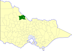
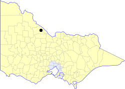
The Shire of Kerang was a local government area located in northwestern Victoria, Australia, along the Murray River. The shire covered an area of 3,254.45 square kilometres (1,256.6 sq mi), and existed from 1862 until 1995. From 1966 onwards, Kerang itself was managed by a separate entity; the Borough of Kerang.

The Shire of Wycheproof was a local government area about 130 kilometres (81 mi) northwest of Bendigo in northwestern Victoria, Australia. The shire covered an area of 4,110.3 square kilometres (1,587.0 sq mi), and existed from 1894 until 1995.
The Borough of Kerang was a local government area in northwestern Victoria, Australia. The borough, for most of its history part of the surrounding Shire of Kerang, covered an area of 22.60 square kilometres (8.7 sq mi), and existed from 1966 until 1995.
The Heathcote District Football League (HDFL) is an Australian rules football league based in the Heathcote region and major Bendigo area with clubs based in the regions of City of Greater Bendigo, Shire of Campaspe, and Shire of Gannawarra

Macorna is a small community town within the Shire of Gannawarra, Australia. The community has only a couple of houses, but it has a Football Netball Club, Cricket Club, Landcare Group, Fire Brigade Station and a Pony Club. The town is 85 metres above sea level.
Beauchamp is a place in Victoria, Australia in the local government area of the Rural City of Swan Hill and the Shire of Gannawarra. The post office opened in 1902 and closed on 31 December 1944.

Myall is a locality in the local government area of the Shire of Buloke, Victoria, Australia. It had a post office that was opened on 24 March 1891, then it was closed on 20 June 1965.

Bael Bael is a locality located in the Shire of Gannawarra of Victoria. It contains Lake Bael Bael and the heritage listed Bael Bael Homestead.

Lake Meran is a locality in north central Victoria, Australia. The locality is shared between the Shire of Gannawarra and the Shire of Loddon, 285 kilometres (177 mi) north west of the state capital, Melbourne.

Horfield is a locality in northern Victoria, Australia. The locality is in the Shire of Gannawarra, 267 kilometres (166 mi) north west of the state capital, Melbourne.
Gannawarra Solar Farm is a photovoltaic solar power station in the Gannawarra Shire, 13 kilometres (8.1 mi) west of Kerang in the Australian state of Victoria. It generates up to 60 MWdc electricity and exports up to 50.61 MWAC to the National Electricity Market at 66 kV.

Myall Creek is a locality split between the local government areas of Inverell Shire and the Gwydir Shire in New South Wales, Australia. In the 2016 census, Myall Creek had a population of 38 people.