
Lindsay Point is a locality in northwestern Victoria, Australia, located approximately 130 km from Mildura. Its northern extremity, located at 33.981°S 140.963°E, is less than one kilometre from the South Australian town of Murtho and is notable for being the only location in Victoria that lies to the west of a portion of the state of South Australia.

Waitchie is a locality in Victoria, Australia, located approximately 44 km from Swan Hill, Victoria. At the 2006 census, Waitchie had a population of 118, decreasing to 48 at the 2016 census.

Lake Tyrrell is a locality in Victoria, Australia, located approximately 95 km from Robinvale, Victoria. The locality is named after the nearby Lake Tyrrell.

Balliang is a locality in Victoria, Australia. It is divided between the Shire of Moorabool and City of Greater Geelong local government areas. It lies north of Geelong and 54 kilometres (34 mi) from the state capital, Melbourne. At the 2016 census, Balliang had a population of 290.

Bessiebelle is a locality in western Victoria, Australia. The locality is in the Shire of Moyne local government area, in what is commonly known as the Western District. Besiebelle is in the County of Normanby cadastral division, approximately 311 kilometres (193 mi) west of the state capital, Melbourne, on the Eumeralla River adjacent to the Mount Eccles National Park.
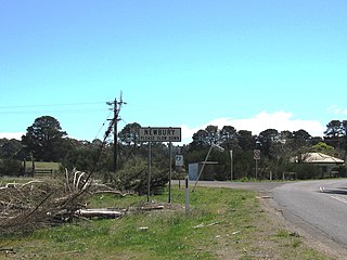
Newbury is a locality in central Victoria, Australia. The locality is in the Shire of Hepburn, 130 kilometres (81 mi) north west of the state capital, Melbourne. At the 2016 census, Newbury had a population of 71. It lies between Trentham, Victoria and Blackwood, Victoria.

Lake Meran is a locality in north central Victoria, Australia. The locality is shared between the Shire of Gannawarra and the Shire of Loddon, 285 kilometres (177 mi) north west of the state capital, Melbourne.
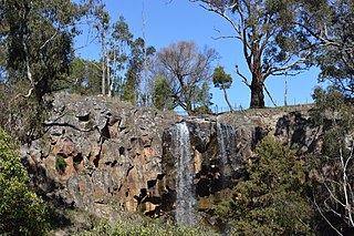
Sailors Falls is a locality in central Victoria, Australia. The locality is in the Shire of Hepburn, 108 kilometres (67 mi) north west of the state capital, Melbourne. The locality is named for the eponymous falls on Sailors Creek, a tributary of the Loddon River

Sandon is a locality in central Victoria, Australia. The locality is split between the Shire of Mount Alexander and the Shire of Hepburn, 106 kilometres (66 mi) north west of the state capital, Melbourne.

Campbelltown is a locality in central Victoria, Australia. The locality is split between the Shire of Hepburn, the Shire of Central Goldfields and the Shire of Mount Alexander, 140 kilometres (87 mi) north west of the state capital, Melbourne.

Glenmore is a locality in central Victoria, Australia. The locality is in the Shire of Moorabool, 70 kilometres (43 mi) west of the state capital, Melbourne.

Morrisons is a locality in central Victoria, Australia. The locality is on the Moorabool River and shared between the Shire of Moorabool and Golden Plains Shire, 99 kilometres (62 mi) west of the state capital, Melbourne and 40 kilometres (25 mi) south east of the regional city of Ballarat.

Callawadda is a locality in the Wimmera region of western Victoria, Australia. The locality is in the Shire of Northern Grampians, 262 kilometres (163 mi) west of the state capital, Melbourne.

Ravenswood is a locality in north central Victoria, Australia. The locality is in the City of Greater Bendigo local government area, 136 kilometres (85 mi) north of the state capital, Melbourne.

Coghills Creek is a locality in central Victoria, Australia. The locality is in the City of Ballarat local government area, 136 kilometres (85 mi) west of the state capital, Melbourne.

Windermere is a locality in central Victoria, Australia. The locality is in the City of Ballarat local government area, 134 kilometres (83 mi) west of the state capital, Melbourne.
Trentham East is a locality in central Victoria, Australia. The locality is in the Shire of Macedon Ranges local government area, 87 kilometres (54 mi) north west of the state capital, Melbourne.
Ercildoune is a locality in western Victoria, Australia. The locality is noted for the significant and unusual historic buildings and gardens found at the Ercildoune Homestead. At the 2016 census, Ercildoune and the surrounding area had a population of 70.

Victoria Hill is a locality spit between the Southern Downs Region and the Toowoomba Region, both in Queensland, Australia. In the 2016 census, Victoria Hill had a population of 30 people.
Victoria Plains is a rural locality in the Mackay Region, Queensland, Australia. In the 2016 census, Victoria Plains had a population of 364 people.

