The Rural City of Ararat is a local government area in Victoria, Australia, located in the western part of the state. It covers an area of 4,230 square kilometres (1,630 sq mi) and at the 2016 Census had a population of over 11,000.

The Rural City of Swan Hill is a local government area in Victoria, Australia, located in the north-western part of the state. It covers an area of 6,117 square kilometres (2,362 sq mi) and, at the 2016 Census, had a population of 20,584. It includes the towns of Swan Hill, Lake Boga, Manangatang, Nyah, Nyah West, Piangil, Robinvale, Ultima and Woorinen South. It was formed in 1995 from the amalgamation of the City of Swan Hill, Shire of Swan Hill and part of the Shire of Kerang.

The Shire of Buloke is a local government area in Victoria, Australia, located in the western part of the state. It covers an area of 8,004 square kilometres (3,090 sq mi) and, at the 2011 Census, had a population of 6,384. It includes the towns of Birchip, Charlton, Donald, Sea Lake and Wycheproof. It was formed in 1995 from the amalgamation of the Shire of Wycheproof, Shire of Birchip, Shire of Charlton, Shire of Donald, and parts of the Shire of Kara Kara.

The Shire of Colac Otway is a local government area in the Barwon South West region of Victoria, Australia, located in the south-western part of the state. It covers an area of 3,433 square kilometres (1,325 sq mi) and at the 2016 Census had a population of almost 21,000. It includes the towns of Apollo Bay, Beeac, Beech Forest, Birregurra, Colac, Cressy, Forrest, Johanna, Kennett River, Lavers Hill, Warrion and Wye River. It was formed in 1994 from the amalgamation of the City of Colac, Shire of Colac, Shire of Otway and part of the Shire of Heytesbury.

The Shire of Corangamite is a local government area in the Barwon South West region of Victoria, Australia, located in the south-western part of the state. It covers an area of 4,407 square kilometres (1,702 sq mi) and at the 2016 Census had a population of approximately 16,000. It includes the towns of Camperdown, Terang, Cobden, Timboon, Port Campbell and Skipton. It was formed in 1994 from the amalgamation of the Town of Camperdown, Shire of Hampden, Shire of Heytesbury, and parts of the Shire of Otway, Shire of Mortlake and Shire of Warrnambool.

The Shire of East Gippsland is a local government area in Gippsland, Victoria, Australia, located in the eastern part of the state. It covers an area of 20,931 square kilometres (8,082 sq mi) and at the 2016 Census had a population of approximately 45,000.

The Shire of Hindmarsh is a local government area in Victoria, Australia, located in the western part of the state. It covers an area of 7,527 square kilometres (2,906 sq mi) and at the 2016 Census had a population of over 5,500.

The Shire of Moira is a local government area in the Hume region of Victoria, Australia, located in the north-east part of the state. It covers an area of 4,045 square kilometres (1,562 sq mi) and at the 2016 Census had a population of over 29,000.

The Shire of South Gippsland is a local government area in Victoria, Australia, located in the south-eastern part of the state. It covers an area of 3,305 square kilometres (1,276 sq mi) and, at the 2016 Census had a population of over 28,000.

The Shire of Strathbogie is a local government area in the Hume region of Victoria, Australia, located in the north-east part of the state. It covers an area of 3,302 square kilometres (1,275 sq mi) and at the 2016 Census had a population of over 10,000.

The Shire of Yarriambiack is a local government area of Victoria, Australia, located in the north-western part of the state. It covers an area of 7,158 square kilometres (2,764 sq mi) and, at the 2016 Census, had a population of 6,674. It includes the towns of Hopetoun, Murtoa, Rupanyup and Warracknabeal. It was formed in 1995 from the amalgamation of the Shire of Warracknabeal, Shire of Karkarooc, and parts of the Shire of Dunmunkle and Shire of Wimmera.

Balliang is a locality in Victoria, Australia. It is divided between the Shire of Moorabool and City of Greater Geelong local government areas. It lies north of Geelong and 54 kilometres (34 mi) from the state capital, Melbourne. At the 2016 census, Balliang had a population of 290.

Mirani is a town and locality in the state of Queensland, Australia. In the 2016 census, Mirani had a population of 1,541 people.
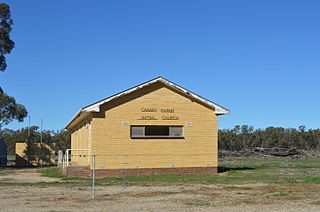
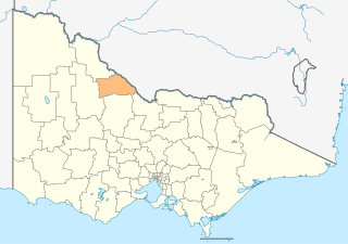
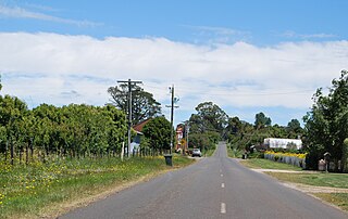
Canary Island is a locality in north central Victoria, Australia. The locality is in the Shire of Loddon and on the Loddon River, 259 kilometres (161 mi) north west of the state capital, Melbourne. The locality is an inland island formed by Twelve Mile Creek - an anabranch of the Loddon River.

Sandon is a locality in central Victoria, Australia. The locality is split between the Shire of Mount Alexander and the Shire of Hepburn, 106 kilometres (66 mi) north west of the state capital, Melbourne.

Campbelltown is a locality in central Victoria, Australia. The locality is split between the Shire of Hepburn, the Shire of Central Goldfields and the Shire of Mount Alexander, 140 kilometres (87 mi) north west of the state capital, Melbourne.

Miga Lake is a locality in western Victoria, Australia. The locality is in the Shire of West Wimmera local government area, 360 kilometres (220 mi) west north west of the state capital, Melbourne.

Huon is a locality in north east Victoria, Australia. The locality is in the Shire of Indigo local government area and on Lake Hume, 347 kilometres (216 mi) north east of the state capital, Melbourne.

Old Tallangatta is a locality in north east Victoria, Australia. The locality is in the Shire of Towong local government area, at the upper end of the Mitta Arm of Lake Hume near the confluence of the Mitta Mitta River and Tallangatta Creek, 372 kilometres (231 mi) north east of the state capital, Melbourne.
Trentham East is a locality in central Victoria, Australia. The locality is in the Shire of Macedon Ranges local government area, 87 kilometres (54 mi) north west of the state capital, Melbourne.