Boort

Last updated • 3 min readFrom Wikipedia, The Free Encyclopedia

Boort
Victoria
Boort Godfrey Street 002.JPG
Godfrey Street, the main street of Boort
Australia Victoria Loddon Shire location map.svg
Red pog.svg
Boort
Coordinates 36°06′S143°43′E / 36.100°S 143.717°E / -36.100; 143.717
Population873 (2016 census) [1]
Postcode(s) 3537
Elevation90 m (295 ft)
Location
LGA(s) Shire of Loddon
State electorate(s) Murray Plains
Federal division(s) Mallee
Mean max tempMean min tempAnnual rainfall
22.6 °C
73 °F
9.2 °C
49 °F
395.8 mm
15.6 in
Railway Hotel, Boort in 2018 Railway Hotel, Boort, Victoria.jpg
Railway Hotel, Boort in 2018

Boort ( /ˈbɔːrt/ ) is a town in Victoria, Australia, located next to Lake Boort, in the Shire of Loddon. The town is known for its native birdlife.

Contents

Main sources of employment are retail, olive processing and tourism. Agriculture is a major industry and employer in the Boort region. Produce includes cereal crops, tomatoes, canola, olives, hay and wool.

History

The traditional owners of Boort are the Djadjawurrung. Boort is a Djadjawurrung word meaning "Smoke from the hill". The area is home to many scar trees which are of cultural significance. [2] It is estimated that there are over five-hundred scar trees in the area.

The township of Boort takes its name from the Boort pastoral run, established in 1846 by John Bear. [3] Initially located southeast of Lake Boort, the Boort homestead marked the area's early European settlement, while the township itself emerged northwest of the lake. In the late 1840s, Frederick Godfrey acquired the pastoral run and diverted water from the Loddon River into Keningapanule Creek, which eventually formed the swampy depression known today as Lake Boort. By the 1870s, farm selections were steadily established in the Boort district, and water infrastructure followed with the creation of the Loddon Waterworks Trust in 1882, later succeeded by a local irrigation trust in 1888. Boort railway station opened in 1883, linking it to Wedderburn Junction and eventually Quambatook. [4]

In 1905, the State Rivers and Water Supply Commission absorbed Boort's irrigation trust and extended the Waranga Eastern Channel to the district in the 1920s, spurring population growth through improved water access and a shift toward urban living. [3] Key developments included a new hospital in 1923, its upgrade to a District Hospital in 1961 and a high school in 1963. Agricultural land west of Boort faced salinity issues from rising water tables, but laser profiling of paddocks has improved drainage and reduced water retention, helping sustain the region’s productivity. [3]

Population

At the 2016 census, Boort had a population of 873. 83.8% of people were born in Australia and 87.9% of people spoke only English at home. The most common responses for religion were No Religion 26.9%, Uniting Church 15.0% and Catholic 12.5%. [1]

Sporting activities

Boort is known as The Northern Oasis. Lake Boort is central to the town and is used for water sports including skiing, sailing, duck hunting, fishing and swimming.

Boort has an Australian rules football team, Boort Football, Hockey, Netball Club competes in the North Central Football League. Notable players from Boort are VFL Brownlow Medallist John Schultz. The team previously recruited ex-AFL player Lance Picioane. The club colours are black and white.

Golfers play at the Boort Golf Club on Charlton Road. [5]

Infrastructure

The Post Office opened on 14 August 1874, [6] and the railway arrived in 1883.

Boort has a hospital, pharmacy, P-12 school, butcher shop, newsagent, hairdresser, supermarket, hardware store, tyre service, mechanic, veterinary service and community centre.

Notable residents

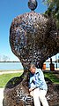
Metal Sculpture Competition

Boort was the home of John Piccoli (died 22 April 2021), dubbed "The Spanner Man", a farmer who in his spare time created sculptures entirely from discarded spanners. [7] Inspired by his work, Boort hosts an annual competition for artists in metal sculpture, resulting in a trail of works around Little Lake Boort. [8]

Climate

Climate data for Boort, elevation 103 m (338 ft)
MonthJanFebMarAprMayJunJulAugSepOctNovDecYear
Record high °C (°F)45.0
(113.0)
43.0
(109.4)
39.5
(103.1)
33.2
(91.8)
28.6
(83.5)
21.2
(70.2)
24.2
(75.6)
27.2
(81.0)
33.1
(91.6)
36.5
(97.7)
41.6
(106.9)
42.0
(107.6)
45.0
(113.0)
Mean daily maximum °C (°F)31.3
(88.3)
31.0
(87.8)
27.6
(81.7)
22.4
(72.3)
17.9
(64.2)
14.4
(57.9)
13.9
(57.0)
15.7
(60.3)
18.6
(65.5)
22.3
(72.1)
26.3
(79.3)
29.5
(85.1)
22.6
(72.7)
Mean daily minimum °C (°F)14.8
(58.6)
15.3
(59.5)
13.0
(55.4)
9.5
(49.1)
6.8
(44.2)
4.4
(39.9)
3.7
(38.7)
4.6
(40.3)
6.2
(43.2)
8.3
(46.9)
10.8
(51.4)
13.2
(55.8)
9.2
(48.6)
Record low °C (°F)6.0
(42.8)
7.0
(44.6)
4.2
(39.6)
0.9
(33.6)
−0.5
(31.1)
−3.5
(25.7)
−3.1
(26.4)
−1.0
(30.2)
−0.6
(30.9)
−1.0
(30.2)
2.7
(36.9)
5.5
(41.9)
−3.5
(25.7)
Average rainfall mm (inches)25.4
(1.00)
26.0
(1.02)
25.8
(1.02)
28.0
(1.10)
37.9
(1.49)
38.6
(1.52)
37.9
(1.49)
41.2
(1.62)
38.1
(1.50)
39.6
(1.56)
33.5
(1.32)
27.3
(1.07)
399.8
(15.74)
Average rainy days (≥ 1.0 mm)2.52.32.73.45.16.16.77.05.55.23.63.053.1
Source: Australian Bureau of Meteorology [9]

See also

Related Research Articles

<span class="mw-page-title-main">Terang</span> Town in Victoria, Australia

Terang is a town in the Western District of Victoria, Australia. The town is in the Shire of Corangamite and on the Princes Highway 212 kilometres (132 mi) south west of the state's capital, Melbourne. At the 2006 census, Terang had a population of 1,824. At the 2001 census, Terang had a population of 1,859. The population of Terang has since risen according to the 2011 Census; the population is now 2,348, of which 1,155 are male and 1,193 are female, with the median age being 44.

<span class="mw-page-title-main">Renmark, South Australia</span> Town in South Australia

Renmark is a town in South Australia's rural Riverland area, and is located 254 km (157.83 mi) northeast of Adelaide, on the banks of the River Murray. The Sturt Highway between Adelaide and Sydney runs through the town; Renmark is the last major town encountered in South Australia when driving this route. It is a few kilometres west of the SA–Victoria and SA–NSW borders. It is 31 m (101.71 ft) above sea level.

<span class="mw-page-title-main">Hillston, New South Wales</span> Town in New South Wales, Australia

Hillston is a township in western New South Wales, Australia, in Carrathool Shire, on the banks of the Lachlan River. It was founded in 1863 and at the 2021 census had a population of 1,547.

<span class="mw-page-title-main">Loddon River</span> River in Victoria, Australia

The Loddon River, an inland river of the north–central catchment, part of the Murray-Darling basin, is located in the lower Riverina bioregion and Central Highlands and Loddon Mallee regions of the Australian state of Victoria. The headwaters of the Loddon River rise on the northern slopes of the Great Dividing Range east of Daylesford and descend to flow north into the Little Murray River, near Swan Hill. The river is impounded by the Cairn Curran and Laanecoorie reservoirs.

<span class="mw-page-title-main">Kerang</span> Town in Victoria, Australia

Kerang is a town on the Loddon River in northern Victoria in Australia. It is the commercial centre to an irrigation district based on livestock, horticulture, lucerne and grain. It is located 279 kilometres (173 mi) north-west of Melbourne on the Murray Valley Highway a few kilometres north of its intersection with the Loddon Valley Highway, elevation 78 metres (256 ft). At the 2021 census, Kerang had a population of 3,960. Kerang is believed to be an Aboriginal word for Cockatoo. It is home to Australia's largest solar and battery farm, which was opened in June 2019. The 50-megawatt battery system is located outside of Kerang and stores 100 per cent renewable energy. The 2,000 solar panels have become a tourist attraction and are drawing many businesses to the town.

<span class="mw-page-title-main">Nicholls, Australian Capital Territory</span> Suburb of Canberra, Australian Capital Territory

Nicholls is a suburb in the Canberra, Australia district of Gungahlin. It was named after Sir Douglas Nicholls (1906–1988) who was born at Cummeragunja Aboriginal mission, New South Wales. Nicholls was a footballer, pastor, activist, and Governor of South Australia, 1976–1977. In line with the philosophy of naming Canberra's streets, those of Nicholls are named after sportspeople. The suburb incorporates a large shallow body of water, designated Gungahlin Pond, with The Lakes golf course and the greatest number of residential streets on one side and a small cluster of residential streets, the "pondside promenade", named after birds, on the other. There is no direct connecting road between the two.

<span class="mw-page-title-main">Camperdown, Victoria</span> Town in Victoria, Australia

Camperdown is a town in southwestern Victoria, Australia, 190 kilometres (120 mi) west of the state capital, Melbourne. At the 2016 census, Camperdown had a population of 3,369.

<span class="mw-page-title-main">Cohuna, Victoria</span> Town in Victoria, Australia

Cohuna is a town situated 274 kilometres (170 mi) north of Melbourne, on the Murray Valley Highway, in northern Victoria, Australia. At the 2016 census, Cohuna had a population of 2,415.

<span class="mw-page-title-main">Numurkah</span> Town in Victoria, Australia

Numurkah is a town in Victoria, Australia, located on the Goulburn Valley Highway, 37 kilometres (23 mi) north of Shepparton, in the Shire of Moira. At the 2016 census, Numurkah had a population of 4,768.

<span class="mw-page-title-main">Pyramid Hill, Victoria</span> Town in Victoria, Australia

Pyramid Hill is a town in the Shire of Loddon, Victoria, Australia, between Bendigo and Kerang. As of the 2021 census, it had a population of 598. The town, which is named for a nearby hill, has walking trails and historic Art Deco architecture.

<span class="mw-page-title-main">Swan Hill</span> City in Victoria, Australia

Swan Hill is a city in the northwest of Victoria, Australia on the Murray Valley Highway and on the south bank of the Murray River, downstream from the junction of the Loddon River. At the 2021 census, Swan Hill had a population of 11,508.

<span class="mw-page-title-main">Ultima, Victoria</span> Town in Victoria, Australia

Ultima is a town in the Rural City of Swan Hill, Victoria, Australia. The town is located 353 kilometres (219 mi) north-west of the state capital, Melbourne, and 35 kilometres (22 mi) south-west of Swan Hill. At the 2021 census, Ultima had a population of 173, down from 333 in 2011.

<span class="mw-page-title-main">Colbinabbin</span> Town in Victoria, Australia

Colbinabbin is a town in the Shire of Campaspe Victoria, Australia. At the 2021 census, Colbinabbin had a population of 285.

<span class="mw-page-title-main">Sea Lake</span> Town in Victoria, Australia

Sea Lake is a town in the Mallee district of north-west Victoria, Australia and is situated on the southern shores of Lake Tyrrell. The town is located on the Calder Highway, 351 kilometres (218 mi) north-west of Melbourne, and 73 kilometres (45 mi) west of Swan Hill. Sea Lake is in the heart of Australia's wheat belt, and is the main township for a number of wheat farms in the region. At the 2021 census, Sea Lake had a population of 619.

<span class="mw-page-title-main">Marong</span> Suburb of Bendigo, Victoria, Australia

Marong is a town in Victoria, Australia. At the 2016 census, Marong and the surrounding area had a population of 1,416. It is 17 kilometres (11 mi) to the west of Bendigo. Its local government area is the City of Greater Bendigo. The town is at the junction of the Calder Highway (A79) and the Calder Alternate Highway (A790).

<span class="mw-page-title-main">Bridgewater On Loddon, Victoria</span> Town in Victoria, Australia

Bridgewater On Loddon is a town in north central Victoria, Australia. The town is located on the Calder Highway, north-west of Bendigo, astride the Loddon River. At the 2021 census, Bridgewater On Loddon had a population of 341. The rural area which surrounds Bridgewater on Loddon is named simply "Bridgewater".

<span class="mw-page-title-main">Eaglehawk, Victoria</span> Suburb of Bendigo, Victoria, Australia

Eaglehawk is a suburb within the City of Greater Bendigo and a former gold-mining town in Victoria, Australia.

<span class="mw-page-title-main">Campbells Creek, Victoria</span> Town in Victoria, Australia

Campbells Creek is a town in Victoria, Australia.

<span class="mw-page-title-main">Djadjawurrung</span> Aboriginal Australian people in Victoria

The Djadjawurrung or Dja Dja Wurrung, also known as the Djaara or Jajowrong people and Loddon River tribe, are an Aboriginal Australian people who are the traditional owners of lands including the water catchment areas of the Loddon and Avoca rivers in the Bendigo region of central Victoria, Australia. They are part of the Kulin alliance of Aboriginal Victorian peoples. There are 16 clans, which adhere to a patrilineal system. Like other Kulin peoples, there are two moieties: Bunjil the eagle and Waa the crow.

Tragowel is a locality in the north-western Victoria, Australia. It is located 267 kilometres (166 mi) north-north-west of the state capital, Melbourne.

References

  1. 1 2 Australian Bureau of Statistics (27 June 2017). "Boort (State Suburb)". 2016 Census QuickStats. Retrieved 13 July 2018. OOjs UI icon edit-ltr-progressive.svg
  2. "Boort Scar Trees | Boort". boort.com.au. Retrieved 12 January 2025.
  3. 1 2 3 "Boort | Victorian Places". www.victorianplaces.com.au. Retrieved 12 January 2025.
  4. "Boort" . Retrieved 12 January 2025.
  5. Golf Select, Boort , retrieved 11 May 2009
  6. Phoenix Auctions History, Post Office List , retrieved 19 February 2021
  7. Jim Wenman. "'Spanner Man' leaves a legacy". Australian Broadcasting Corporation. Retrieved 12 February 2023.
  8. "Boort Sculpture by the Lake Trail". The Loddon Visitor Information Centre. Retrieved 12 February 2023.
  9. "Climate statistics for Australian locations- BOORT". 8 July 2024.

Commons-logo.svg Media related to Boort at Wikimedia Commons