Latrobe River

Last updated

Latrobe [1]
La Trobe, [2] LaTrobe
20100426 SaleSwingBridge.jpg
The Sale Swing Bridge over the Latrobe River
Australia Victoria relief location map.jpg
Red pog.svg
Location of the Latrobe River mouth in Victoria
EtymologyIn honour of Charles La Trobe, Lieutenant Governor of the Port Phillip District. [3] [4]
Native nameDurt'yowan (Kurnai)
Location
Country Australia
State Victoria
Region South East Coastal Plain (IBRA), West Gippsland
Local government areas Baw Baw, Wellington, East Gippsland
Physical characteristics
Source Baw Baw plateau, Great Dividing Range
  locationbelow Dick Hill, near Noojee
  coordinates 37°49′33″S145°47′39″E / 37.82583°S 145.79417°E / -37.82583; 145.79417
  elevation764 m (2,507 ft)
Mouth Lake Wellington
  location
east of Sale
  coordinates
37°54′11″S147°37′20″E / 37.90306°S 147.62222°E / -37.90306; 147.62222 Coordinates: 37°54′11″S147°37′20″E / 37.90306°S 147.62222°E / -37.90306; 147.62222
  elevation
1 m (3 ft 3 in)
Length270 km (170 mi)
Basin features
River system West Gippsland catchment
Tributaries 
  left Pioneer Creek, Ada River, Toorongo River, Loch River, Hawthorn Creek, Tanjil River, Anderson Creek, Tyers River, Rintoul Creek, Eaglehawk Creek, Thomson River, Avon River
  rightBennie Creek, Morwell River, Wade Creek, Traralgon Creek, Flynns Creek
National parks The Lakes NP,
Gippsland Lakes CP
[1] [5]

The Latrobe River (or sometimes La Trobe [2] or LaTrobe) is a perennial river of the West Gippsland catchment, located in the West Gippsland region of the Australian state of Victoria. The Latrobe River and its associated sub-catchment is an important source for the Gippsland Lakes, draining the south eastern slopes of the Great Dividing Range.

Contents

Course and features

[[File:D. R. Long - Latrobe River.jpg|left|thumb|Latrobe River, 1883, Daniel Long [ State Library Victoria ]]] The Latrobe River rises below Dick Hill, from the southern slopes of the Baw Baw plateau, part of the Great Dividing Range, between Powelltown and Noojee where it shares a watershed with the Little Yarra River, in a state forestry area. The river flows generally in an easterly direction, then south, and then east again through the Latrobe Valley, joined by seventeen tributaries including the Ada, Toorongo, Loch, Tanjil, Morwell, Tyers, and Thomson rivers, before reaching its mouth in Lake Wellington east of Sale where it forms its confluence with the Avon. It then goes to flow out of Lake Wellington and into Lake Victoria, Within Lake Victoria, south of Bairnsdale, the river forms its confluence with the Forge Creek and Mitchell River and empties into Bass Strait southwest of Lakes Entrance in the Shire of East Gippsland. The river descends 764 metres (2,507 ft) over its 270-kilometre (170 mi) course. [5]

The Latrobe River flows through Lake Narracan, a storage reservoir near Newborough built to supply cooling water for the nearby brown coal fired power stations, and through Lake Victoria before emptying into the Bass Strait. [5] In its upper reaches, the Latrobe River flows adjacent to the Noojee Streamside Reserve and the Tyers Streamside Reserve. As the river reaches its mouth, it flows adjacent to The Lakes National Park and the Gippsland Lakes Coastal Park. [6]

Major road crossings of the river, from upstream to downstream, are located on the Yarra Junction-Noojee Road east of Powelltown; the Mount Baw Baw Road east of Noojee; the Willowgrove Road south of Willow Grove; the Moe-Rawson Road north of Moe; the Moe-Glengarry Road west of Yallourn North; and the Princes Highway north of Rosedale.

The Latrobe River sub-catchment area is managed by the West Gippsland Catchment Management Authority.

Etymology

In the Aboriginal Brataualung language the river is given two names, Durt'yowan, meaning "finger", [7] [8] and Tanjil, with no defined meaning. [9]

According to Les Blake, in 1841 William Adams Brodribb, an early settler, [10] named the river in honour of Charles La Trobe, Lieutenant Governor of the Port Phillip District. [3] A. W. Reed also attributes Brodribb to naming the river in honour of La Trobe; yet Reed claims that the river was discovered by Angus McMillan in 1840 who named the watercourse as Glengarry River. [4]

The Australian Government Gazetteer lists the name of the watercourse as La Trobe River [2] and the river is sometimes spelled as LaTrobe River; meanwhile the Victorian Government Registrar of Geographic Names list the name as Latrobe River. [1]

See also

Related Research Articles

<span class="mw-page-title-main">Baw Baw National Park</span> Protected area in Victoria, Australia

The Baw Baw National Park is a national park located on the boundary between the Victorian Alps and Gippsland regions of Victoria, Australia. The 13,530-hectare (33,400-acre) national park is situated approximately 120 kilometres (75 mi) east of Melbourne and 50 kilometres (31 mi) north of the Latrobe Valley. The park contains the forest covered Baw-Baw Plateau and surrounds the Mount Baw Baw Alpine Resort.

<span class="mw-page-title-main">Morwell</span> City in Victoria, Australia

Morwell is a town in the Latrobe Valley area of Gippsland, in South-Eastern Victoria, Australia approximately 152 km (94 mi) east of Melbourne.

<span class="mw-page-title-main">Latrobe Valley</span> Region in Victoria, Australia

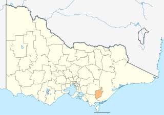
The Latrobe Valley is an inland geographical district and urban area of the Gippsland region in the state of Victoria, Australia. The traditional owners are the Brayakaulung of the Gunai nation. The district lies east of Melbourne and nestled between the Strzelecki Ranges to the south and the Baw Baw Ranges, part of the Great Dividing Range, to the north. Mount St Phillack is the highest peak to the north of the Latrobe Valley, due north of Moe. The highest peak to the south is Mt Tassie, south of Traralgon.

<span class="mw-page-title-main">City of Latrobe</span> Local government area in Victoria, Australia

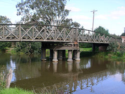
The City of Latrobe is a local government area in the Gippsland region in eastern Victoria, Australia, located in the eastern part of the state. It covers an area of 1,426 square kilometres (551 sq mi) and in June 2018 had a population of 75,211. It is primarily urban with the vast majority of its population living within the four major urban areas of Moe, Morwell, Traralgon, and Churchill, and other significant settlements in the LGA include Boolarra, Callignee, Glengarry, Jeeralang, Newborough, Toongabbie, Tyers, Yallourn North and Yinnar. It was formed in 1994 from the amalgamation of the City of Moe, City of Morwell, City of Traralgon, Shire of Traralgon, and parts of the Shire of Narracan and Shire of Rosedale. The Yallourn Works Area was added in 1996. When formed, the municipality was called the Shire of La Trobe, but on 6 April 2000, it adopted its current name.

<span class="mw-page-title-main">Mount Baw Baw</span> Mountain in Victoria, Australia

Mount Baw Baw is a mountain summit on the Baw-Baw Plateau of the Great Dividing Range, located in Victoria, Australia. The name is from the Woiwurrung language spoken by Eastern Kulin people. It is of uncertain meaning, but possibly signifies, echo, or ghost.

<span class="mw-page-title-main">Avon River (Gippsland, Victoria)</span> River in the Gippsland region of Victoria, Australia

The Avon River is a perennial river of the West Gippsland catchment, located in the West Gippsland region, of the Australian state of Victoria. The Avon, forms an important part of the Latrobe sub-catchment, draining the south eastern slopes of the Great Dividing Range, to form the Gippsland Lakes.

<span class="mw-page-title-main">Thomson River (Victoria)</span> River in Victoria, Australia

The Thomson River, a perennial river of the West Gippsland catchment, is located in the Gippsland region of the Australian state of Victoria.

The Albert River is a perennial river of the West Gippsland catchment, located in the South Gippsland region of the Australian state of Victoria.

<span class="mw-page-title-main">Agnes River (Australia)</span> River in Victoria, Australia

The Agnes River is a perennial river of the West Gippsland catchment, located in the South Gippsland region of the Australian state of Victoria.

The Tarra River is a perennial river of the West Gippsland catchment, located in the South Gippsland region of the Australian state of Victoria.

The Perry River is a perennial river of the West Gippsland catchment, located in the Gippsland region of the Australian state of Victoria.

<span class="mw-page-title-main">Brodribb River</span> River in Victoria, Australia

The Brodribb River is a perennial river of the Snowy River catchment, located in the East Gippsland region of the Australian state of Victoria.

The Ada River is a perennial river of the West Gippsland catchment, located in the West Gippsland region of the Australian state of Victoria.

<span class="mw-page-title-main">Aberfeldy River</span> River in Victoria, Australia

The Aberfeldy River is a perennial river of the West Gippsland catchment, located in the Alpine region of the Australian state of Victoria.

The Toorongo River is a perennial river of the West Gippsland catchment, located in the West Gippsland region of the Australian state of Victoria.

The Loch River is a perennial river of the West Gippsland catchment, located in the West Gippsland region of the Australian state of Victoria.

The Tanjil River is a perennial river of the West Gippsland catchment, located in the West Gippsland region of the Australian state of Victoria.

The Tyers River is a perennial river of the West Gippsland catchment, located in the West Gippsland region of the Australian state of Victoria.

Mount Mueller is a mountain of the Great Dividing Range, located in Victoria, Australia. Mount Mueller has an elevation of 1,460 metres (4,790 ft) AHD .

The Moe River is a perennial river of the West Gippsland catchment, located in the West Gippsland region of the Australian state of Victoria.

References

  1. 1 2 3 "Latrobe River: 19128". Vicnames. Government of Victoria. 2 May 1966. Retrieved 25 June 2015.
  2. 1 2 3 "La Trobe River". Gazetteer of Australia online. Geoscience Australia, Australian Government.
  3. 1 2 Blake, Les (1977). Place names of Victoria. Adelaide: Rigby. p. 294. ISBN   0-727-00250-3.
  4. 1 2 Reed, A. W. (1973). Place names of Australia. Frenchs Forest: Reed Books. p. 135. ISBN   0-589-50128-3.
  5. 1 2 3 "Map of Latrobe River, VIC". Bonzle Digital Atlas of Australia. Retrieved 8 February 2014.
  6. "Parks map search: "latrobe"". Parks Victoria . Government of Victoria. 2014. Retrieved 8 February 2014.
  7. Finch, Janette; Teale, Ruth (1969). "Brodribb, William Adams (1809 - 1886)". Australian Dictionary of Biography . National Centre of Biography, Australian National University. ISSN   1833-7538.