
Hume Dam, formerly the Hume Weir, is a major dam across the Murray River downstream of its junction with the Mitta River in the Riverina region of New South Wales, Australia. The dam's purpose includes flood mitigation, hydro-power, irrigation, water supply and conservation. The impounded reservoir is called Lake Hume, formerly the Hume Reservoir. It is a gated concrete gravity dam with four earth embankments and twenty-nine vertical undershot gated concrete overflow spillways.

The Goulburn River, a major inland perennial river of the Goulburn Broken catchment, part of the Murray-Darling basin, is located in the Alpine, Northern Country/North Central, and Southern Riverina regions of the Australian state of Victoria. The headwaters of the Goulburn River rise in the western end of the Victorian Alps, below the peak of Corn Hill before descending to flow into the Murray River near Echuca, making it the longest river in Victoria at 654 kilometres (406 mi). The river is impounded by the Eildon Dam to create Lake Eildon, the Eildon Pondage, the Goulburn Weir and Waranga Basin.

The Eildon Dam is a rock and earth-fill embankment dam with a controlled spillway across the Goulburn River, is located between the regional towns of Mansfield and Eildon within Lake Eildon National Park, in the Alpine region of Victoria, Australia. The dam's purpose is for the supply of potable water, irrigation, and the generation of hydroelectricity. The impounded reservoir is called Lake Eildon.

The Waranga Dam is a major earthfill embankment dam with an uncontrolled spillway located approximately 150 kilometres (93 mi) north of Melbourne in the North Central region of the Australian state of Victoria. The impounded off-stream reservoir is Waranga Basin and forms part of the Goulburn River irrigation system, irrigating an area of 626 square kilometres (242 sq mi). The dam and reservoir are located in Shire of Campaspe near the City of Greater Shepparton and is located 8 kilometres (5 mi) north-east of Rushworth, 12 kilometres (7.5 mi) south-west of Tatura, and near Murchison. When full, the reservoir covers an area of 58.5 square kilometres (22.6 sq mi).

Goulburn Valley Highway is a highway located in Victoria, Australia. The section north of the Hume Freeway is part of the Melbourne to Brisbane National Highway and is the main link between these two cities as well as a major link between Victoria and inland New South Wales. It is also the most direct route between Melbourne and the major regional centre of Shepparton in Victoria.

Wyangala Dam is a major gated rock fill with clay core embankment and gravity dam with eight radial gates and a concrete chute spillway across the Lachlan River, located in the south-western slopes region of New South Wales, Australia. The dam's purpose includes flood mitigation, hydro-power, irrigation, water supply and conservation. The impounded reservoir is called Lake Wyangala.
The Goulburn Valley is a sub-region, part of the Hume region of the Australian state of Victoria. The sub-region consists of those areas in the catchment of the Goulburn River and other nearby streams, and is part of the Murray-Darling Basin. The Goulburn Valley is bordered on the south by the Great Dividing Range and to the north by the Murray River, the state border with New South Wales. The sub-region is one of Australia's most productive and intensively farmed areas and is predominantly irrigated.

Nagambie is a town in the Goulburn Valley region of Victoria, Australia. The city is on the Goulburn Valley Freeway north of Seymour and in the Shire of Strathbogie. As of 2021 census, Nagambie had a population of 2,254.

Colbinabbin is a town in central Victoria, Australia. The name is derived from aboriginal meaning "the meeting of the black and red soils". At the 2011 census, Colbinabbin and the surrounding area had a population of 297.
The following lists events that happened during 1887 in Australia.

The Rubicon Hydroelectric Scheme is a small run-of-the-river hydroelectric scheme located on the Rubicon and Royston Rivers, north east of Melbourne, 40 km (25 mi) south-west of Alexandra, Victoria, Australia. The scheme commenced in 1922, and was the first state-owned hydroelectric scheme to generate electricity in mainland Australia, and among the first in the world to be remotely controlled. For the first ten years of its operation it supplied on average 16.9% of electricity generated by the State Electricity Commission of Victoria. It is now owned and operated by AGL Energy and contributes approximately 0.02% of Victoria's energy supply.

Irrigation is a widespread practice required in many areas of Australia, the driest inhabited continent, to supplement low rainfall with water from other sources to assist in growing crops and pasture. Overuse or poor management of irrigation is held responsible by some for environmental problems such as soil salinity and loss of habitat for native flora and fauna.

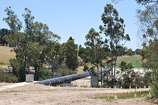
Lake Nagambie is a 170-hectare (420-acre) man–made reservoir located in the Goldfields region of Victoria, Australia. The lake was formed by the damming of the Goulburn River by the Goulburn Weir. The town of Nagambie is on its shores.
Tahbilk Winery is a historic Australian winery with National Trust certification. It is located 120 km (75 mi) north of Melbourne between the townships of Seymour and Nagambie in the Nagambie Lakes a sub region of Goulburn Valley Wine Region. It was established in 1860, and is the oldest family-owned winery and vineyard in Victoria. The winery is part of Australia's First Families of Wine, a prominent Australian wine alliance.
The North–South Pipeline, also known as the Sugarloaf Pipeline, is a water pipeline in Central Victoria, Australia, northeast of Melbourne that is part of Victoria's water system, acting as a link between Melbourne's water grid and the Murray-Goulburn water grid, supplying water via a series of existing and proposed pipelines. The 70-kilometre pipeline was connected to Melbourne in February 2010 to carry water from the Goulburn River to Melbourne's Sugarloaf Reservoir. It is the government's policy that it only be used in times of critical human need: when Melbourne's total water storages are less than 30% full on 30 November of any year. The pipeline can transfer a portion of Lake Eildon's water that is set aside for Melbourne, called the critical water reserve. This was 38,400 megalitres at 2 June 2014, and any changes are based on Goulburn-Murray Water's advice.

The Mulwala Canal is an irrigation canal in the southern Riverina region of New South Wales, Australia. It is the largest irrigation canal in the Southern Hemisphere. The canal, starting at Lake Mulwala, diverts water from the Murray River across the southern Riverina plain to the Edward River at Deniliquin. The canal is 156 km long. The channel has an offtake capacity of 10,000 megalitres (ML) per day and annually supplies over 1,000,000 ML to 700,000 hectares in the Murray Irrigation Area.

Laanecoorie Weir or Laanecoorie Reservoir, is a water storage for irrigation and domestic purposes on the Loddon River, near the towns of Laanecoorie, Victoria and Eddington, Victoria. It was constructed by contractor Andrew O'Keefe (engineer) in conjunction with Joshua Thomas Noble Anderson. This was the second irrigation scheme for Victoria after the Goulburn Weir. Construction commenced in 1889 and took three years to complete. The largest outlet valves in Victoria, manufactured by the United Iron Work of Abraham Roberts, were installed at the weir in 1891.
Berembed Weir is a heritage-listed reservoir on the Murrumbidgee River at Matong, City of Wagga Wagga, New South Wales, Australia. It was designed by Ernest de Burgh and built from 1909 to 1910 by the New South Wales Department of Public Works. It is also known as Berembed Diversion Weir. It was added to the New South Wales State Heritage Register on 2 April 1999.

The Gogeldrie Weir is a heritage-listed former weir and now recreation area and weir at Murrumbidgee River near Narrandera, Leeton Shire, New South Wales, Australia. It was designed and built by WC & IC from 1958 to 1959. It was added to the New South Wales State Heritage Register on 2 April 1999.
Water management in Victoria deals with the management of water resources in and by the Australian State of Victoria.

