
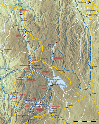
Dartmouth Dam is a large rock-fill embankment dam with an uncontrolled chute spillway across the Mitta Mitta, Gibbo, and Dart rivers, the Morass Creek and a number of small tributaries. The dam is located near Mount Bogong in the north-east of the Australian state of Victoria. The dam's purpose includes irrigation, the generation of hydro-electric power, water supply and conservation. The impounded reservoir is called Dartmouth Reservoir, sometimes called Lake Dartmouth. The Dartmouth Power Station, a hydro-electric power station that generates power to the national grid, is located near the dam wall.

Mitta Mitta River, a perennial river and a direct tributary of the Murray River within the Murray–Darling basin, is located in the Alpine district of Victoria, Australia.
The Snowy Mountains Scheme or Snowy scheme is a hydroelectricity and irrigation complex in south-east Australia. The Scheme consists of sixteen major dams; nine power stations; two pumping stations; and 225 kilometres (140 mi) of tunnels, pipelines and aqueducts that were constructed between 1949 and 1974. The Scheme was completed under the supervision of Chief Engineer, Sir William Hudson. It is the largest engineering project undertaken in Australia.

The Goulburn River, a major inland perennial river of the Goulburn Broken catchment, part of the Murray-Darling basin, is located in the Alpine, Northern Country/North Central, and Southern Riverina regions of the Australian state of Victoria. The headwaters of the Goulburn River rise in the western end of the Victorian Alps, below the peak of Corn Hill before descending to flow into the Murray River near Echuca, making it the longest river in Victoria at 654 kilometres (406 mi). The river is impounded by the Eildon Dam to create Lake Eildon, the Eildon Pondage, the Goulburn Weir and Waranga Basin.

Kiewa River, a perennial river that is part of the Murray catchment within the Murray-Darling basin, is located in the Alpine bioregion, in the Australian state of Victoria.

The Kiewa Hydroelectric Scheme is the largest hydro-electric scheme in the Australian state of Victoria and the second-largest in mainland Australia after the Snowy Mountains Scheme. The scheme is situated in the Australian Alps in north-eastern Victoria about 350 kilometres from Melbourne and is wholly owned by AGL Energy.

The Wimmera River, an inland intermittent river of the Wimmera catchment, is located in the Grampians and Wimmera regions of the Australian state of Victoria. Rising in the Pyrenees, on the northern slopes of the Great Dividing Range, the Wimmera River flows generally north by west and drains into Lake Hindmarsh and Lake Albacutya, a series of ephemeral lakes that, whilst they do not directly empty into a defined watercourse, form part of the Murray River catchment of the Murray-Darling basin.
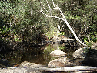
The Rubicon River, an inland perennial river of the Goulburn Broken catchment, part of the Murray-Darling basin, is located in the lower South Eastern Highlands bioregion and Northern Country/North Central regions of the Australian state of Victoria. The headwaters of the Rubicon River rise on the western slopes of the Victorian Alps and descend to flow into the Goulburn River.

The Rubicon Hydroelectric Scheme is a small run-of-the-river hydroelectric scheme located on the Rubicon and Royston Rivers, north east of Melbourne, 40 km (25 mi) south-west of Alexandra, Victoria, Australia. The scheme commenced in 1922, and was the first state-owned hydroelectric scheme to generate electricity in mainland Australia, and among the first in the world to be remotely controlled. For the first ten years of its operation it supplied on average 16.9% of electricity generated by the State Electricity Commission of Victoria. It is now owned and operated by AGL Energy and contributes approximately 0.02% of Victoria's energy supply.
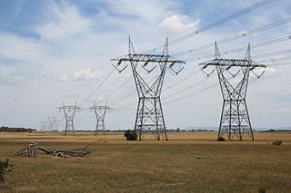
Energy in Victoria, Australia is generated using a number of fuels or technologies, including coal, natural gas and renewable energy sources. Brown coal, historically, was the main primary energy source for the generation of electricity in the state, accounting for about 85% of electricity generation in 2008. The amount of coal-fired power has decreased significantly with the closure in 2017 of the Hazelwood power station which supplied around 20% of Victoria's electricity, and to a lesser extent with the exit of Anglesea power station in 2015. Brown coal is one of the largest contributors to Australia's total domestic greenhouse gas emissions and a source of controversy for the country. Australia is one of the highest polluters of greenhouse gas per capita in the world.
Tooma River, a perennial stream that has had some of its flow diverted as a result of the Snowy Mountains Scheme, is part of the Murray catchment within the Murray–Darling basin and is located in the Australian Alpine region of New South Wales, Australia.
The Coliban River, an inland perennial river of the north–central catchment, part of the Murray-Darling basin, is located in the lower Riverina bioregion and Central Highlands region of the Australian state of Victoria. The headwaters of the Coliban River rise on the northern slopes of the Great Dividing Range and descend to flow north into the Campaspe River with the impounded Lake Eppalock.
Swampy Plain River, a perennial stream that is part of the Murray catchment within the Murray–Darling basin, is located in the Snowy Mountains bioregion of New South Wales, Australia.
Deep Creek Dam is a major ungated concrete gravity dam across the Deep Creek in the Snowy Mountains of New South Wales, Australia. The dam's main purpose is for the generation of hydro-power and is the smallest of the sixteen major dams that comprise the Snowy Mountains Scheme, a vast hydroelectricity and irrigation complex constructed in south-east Australia between 1949 and 1974 and now run by Snowy Hydro.
The Dart River, a perennial river of the North-East Murray catchment of the Murray-Darling basin, is located in the Alpine region of Victoria, Australia. It flows from the northwestern slopes of the Alpine National Park in the Australian Alps, south and joins with the Mitta Mitta River within Lake Dartmouth.
The Gibbo River, a perennial river of the North-East Murray catchment of the Murray-Darling basin, is located in the Alpine and East Gippsland regions of Victoria, Australia. It flows from the northwestern slopes of the Australian Alps, south and joins with Morass Creek southeast of Lake Dartmouth.
The Taponga River, an inland perennial river of the Goulburn Broken catchment, part of the Murray-Darling basin, is located in the lower South Eastern Highlands bioregion, Alpine and Northern Country/North Central regions of the Australian state of Victoria. It flows from the northwestern slopes of the Australian Alps, north and joins with the Big River.
The Murrindindi River, an inland perennial river of the Goulburn Broken catchment, part of the Murray-Darling basin, is located in the lower South Eastern Highlands bioregion and Northern Country/North Central regions of the Australian state of Victoria. The headwaters of the Murrindindi River rise on the western slopes of the Victorian Alps and descend to flow into the Yea River.
The Little Rubicon River, an inland perennial river of the Goulburn Broken catchment, part of the Murray-Darling basin, is located in the lower South Eastern Highlands bioregion and Northern Country/North Central regions of the Australian state of Victoria. The headwaters of the Little Rubicon River rise on the western slopes of the Victorian Alps and descend to flow into the Rubicon River.
Rubicon is a locality in Victoria, Australia, located in the Shire of Murrindindi. It is situated on the Rubicon River. In the 2016 census, Rubicon had a population of 56.
