Buckland River (Victoria)

Last updated

Buckland
East Buckland, [1] West Buckland [2]
Buckland River, Victoria.jpg
The Buckland River at Beveridges Station, in the Mount Buffalo National Park
Australia Victoria relief location map.jpg
Red pog.svg
Location of the Buckland River mouth in Victoria
Location
Country Australia
State Victoria
Region Victorian Alps (IBRA), Victorian Alps
Local government area Alpine Shire
Town Porepunkah
Physical characteristics
SourceBuffalo Range, Victorian Alps
Source confluenceEast and West branches of the Buckland River
  locationbelow The Twins
  coordinates 36°57′40″S146°55′53″E / 36.96111°S 146.93139°E / -36.96111; 146.93139
  elevation556 m (1,824 ft)
Mouth confluence with the Ovens River
  location
Porepunkah
  coordinates
36°41′28″S146°53′55″E / 36.69111°S 146.89861°E / -36.69111; 146.89861 Coordinates: 36°41′28″S146°53′55″E / 36.69111°S 146.89861°E / -36.69111; 146.89861
  elevation
274 m (899 ft)
Length39 km (24 mi)
Basin size322 km2 (124 sq mi)
Basin features
River system North-East Murray catchment,
Murray-Darling basin
Tributaries 
  leftDingo Creek (Victoria), Buckland Creek, Fairley Creek, Murray Creek, Dunphy Creek, Wright Creek (Victoria)
  rightPheasant Creek (Victoria), Clear Creek (Victoria)
National parks Alpine National Park; Mount Buffalo National Park
[3]

The Buckland River, a perennial river [4] of the North-East Murray catchment of the Murray-Darling basin, is located in the Alpine region of Victoria, Australia. It flows from the eastern slopes of the Buffalo Range in the Australian Alps, joining with the Ovens River at Porepunkah. [3]

Contents

Location and features

Formed by the east and west branches of the river, the headwaters of the Buckland River rise in the Barry Mountains below Mount Selwyn and The Twins at an elevation exceeding 1,000 metres (3,300 ft) above sea level. The east and west branches of the river reach their confluence upstream of Beveridges Station, where the watercourse becomes Buckland River. The river flows generally north, much of its course through the remote Mount Buffalo National Park, joined by eight minor tributaries, before reaching its confluence with the Overs River near the small settlement of Porepunkah, located within the Alpine Shire. The river descends 282 metres (925 ft) over its 39-kilometre (24 mi) course. [3]

The catchment area to the off-take weir at the Buckland Bridge is approximately 322 square kilometres (124 sq mi). It is about 13 kilometres (8.1 mi) wide by 31 kilometres (19 mi) long, with the longer axis lying approximately north-south.[ citation needed ] The whole catchment is within the Alpine Shire and the Parishes of Buckland, Coolungubra, Harrietville, Maharatta, Morockdong, Panbullu and Towamba of the County of Delatite. The catchment was proclaimed by the Governor of Victoria, Sir Henry Winneke, on 20 June 1979. [5]

Flooding

The Buckland River frequently floods. The Bureau of Meteorology has established automated river height monitoring at Upper Buckland and Harris Lane. Rainfall may increase in the range of 1,100–1,640 millimetres (43–65 in) due to the influence of elevation and topography. During the winter months most of the catchment with elevations above 1,500 metres (4,900 ft) AHD receives its precipitation as snow, and in a normal winter, snow accumulates from June until September. A flash flood in the Buckland River following the bushfires in the summer of 2003 resulted in a major fish kill in the Ovens River and threatened town and rural water supplies. [6]

Physiography

The catchment lies on the northern slopes of the Great Divide, and ranges in elevation from 350 metres (1,150 ft) at the off-take to 1,703 metres (5,587 ft) at The Twins. Most of the catchment is steep to very steep being the foothills of the Victorian Alps. There is an overall similarity of hill slopes in an area of physiographically massive rocks. Along the Buckland River rolling to hilly valley slopes prevail with narrow terraces and a narrow flood plain present in the lower reaches.[ citation needed ]

Geology

The major part of the catchment consists of generally fine grained felspathic sandstone beds up to one metre thick interbedded with dark grey shale and siltstone of Middle to Upper Ordovician age. There is a small area of intrusive rock of Devonian age consisting of granite and granodiorite near Paddys Hill and a larger area of similar material of Silurian age at Mount Selwyn. Along the middle reaches of the Buckland River there are alluvial and colluvial deposits of Pleistocene age consisting of clay, silt, sand, gravel and conglomerate. Recent deposits of alluvium with a similar composition extend along the river channel for about 2.5 km upstream of the Buckland Bridge. [7]

Gold rush

Miners at Fairleys Creek, Buckland Valley Fairleys Creek gold mine.jpg
Miners at Fairleys Creek, Buckland Valley

During the Victorian gold rush of the 1850s the Buckland Valley was home to several thousand Chinese miners. On 4 July 1857, following a meeting at a Buckland Valley public house, approximately 100 European miners violently expelled most Chinese miners from the area in an event referred to as the Buckland Riot. [8] [9] The Buckland River was rich in alluvial gold and was dredged extensively in the 19th century. Tributaries also yielded rich results.

In April 1897 crushing machinery was placed on the ground at Fairleys Creek with £30,000 working capital from London-based investors. The 30head battery was the largest set up on any of the Upper Ovens goldfields. In November 1898 it was reported that crushing had been carried out continuously ... the stone was of a low yield but reported to be paying handsomely. [10]

Notable people

Alice Manfield was a guide who was born in the Buckland Valley in 1878; called Guide Alice, she became significant in the early days of the white settlement of Mount Buffalo and in the establishment of the Mount Buffalo National Park. [11]

See also

Related Research Articles

<span class="mw-page-title-main">Mount Buffalo National Park</span> Protected area in Victoria, Australia

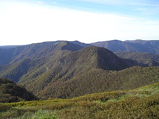
The Mount Buffalo National Park is a national park in the alpine region of Victoria, Australia. The 31,000-hectare (77,000-acre) national park is located approximately 350 kilometres (220 mi) northeast of Melbourne in the Australian Alps. Within the national park is Mount Buffalo, a moderately high mountain plateau, with an elevation of 1,723 metres (5,653 ft) above sea level.

<span class="mw-page-title-main">Kiewa River</span> River in Victoria, Australia

Kiewa River, a perennial river that is part of the Murray catchment within the Murray-Darling basin, is located in the Alpine bioregion, in the Australian state of Victoria.

<span class="mw-page-title-main">Bright, Victoria</span> Town in Victoria, Australia

Bright is a town in northeastern Victoria, Australia, 319 metres above sea level at the southeastern end of the Ovens Valley. At the 2021 census, Bright had a population of 2,620. It is located in the Alpine Shire local government area.

<span class="mw-page-title-main">Ovens River</span> The Ovens River joins the Murray River a little east of the twin towns of Yarrawonga and Mulwala.

The Ovens River, a perennial river of the north-east Murray catchment, part of the Murray-Darling basin, is located in the Alpine and Hume regions of the Australian state of Victoria.

<span class="mw-page-title-main">King River (Victoria)</span> River in Victoria (Australia)

The King River, a perennial river of the North-East Murray catchment of the Murray-Darling basin, is located in the Alpine and Hume regions of Victoria, Australia. It flows from the northwestern slopes of the Alpine National Park in the Australian Alps, through the King Valley, and joining with the Ovens River at the rural city of Wangaratta.

The Morses Creek, is a perennial stream of the North-East Murray catchment of the Murray-Darling basin, is located in the Alpine region of Victoria, Australia. It flows from the northern slopes of the Mount Buffalo National Park in the Australian Alps, joining with the Ovens River at Bright.

<span class="mw-page-title-main">Mount Buggery (Alpine Shire, Victoria)</span> Mountain in Victoria, Australia

Mount Buggery is a mountain located in the Alpine Shire within the Alpine National Park in the alpine region of Victoria, Australia. The mountain is located on the end of a ridgeline known as the Crosscut Saw between Mount Speculation and Mount Howitt, both located 4 kilometres (2.5 mi) to the south of Mount Buggery.

<span class="mw-page-title-main">Porepunkah</span> Town in Victoria, Australia

Porepunkah is a town in northeast Victoria, Australia on the Great Alpine Road, at the foot of Mount Buffalo 320 kilometres (199 mi) northeast of the state capital, Melbourne and 5 kilometres (3 mi) northwest of Bright. It is part of Alpine Shire local government area and on the banks of the Ovens River, near the Buckland River junction. At the 2016 census, Porepunkah had a population of 941.

The Tarwin River is a perennial river of the West Gippsland catchment, located in the South Gippsland region of the Australian state of Victoria. The Tarwin River is the primary river system within South Gippsland Shire and has a catchment area of approximately 1,500 square kilometres (580 sq mi), predominantly rural with small pockets of residential land use. It flows south from the Strzlecki Ranges and discharges in the eastern reaches of Anderson Inlet, a shallow estuary connected to Bass Strait.

<span class="mw-page-title-main">Alice Manfield</span> Australian mountain guide

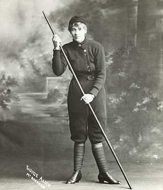
Alice Manfield commonly known as Guide Alice, was a mountain guide, amateur naturalist, chalet owner, photographer, and early feminist figure from Victoria, Australia. Her pioneering work at Mount Buffalo from the 1890s to the 1930s led to her becoming a tourist attraction in her own right, and helped lead to the establishment of the Mount Buffalo National Park.

<span class="mw-page-title-main">Big River (Mitta Mitta River, Victoria)</span> River in Victoria, Australia

The Big River, a perennial river of the North-East Murray catchment of the Murray-Darling basin, is located in the East Gippsland and Alpine regions of Victoria, Australia. It flows from the northern slopes of Falls Creek in the Australian Alps, joining with the Cobungra River near Anglers Rest to form the Mitta Mitta River.

<span class="mw-page-title-main">Bundara River</span> River in Victoria, Australia

The Bundara River, a perennial river of the North-East Murray catchment of the Murray-Darling basin, is located in the East Gippsland and Alpine regions of Victoria, Australia.

The Dry River is a perennial river of the Mitchell River catchment, located in the Alpine region of the Australian state of Victoria.

The Tanjil River is a perennial river of the West Gippsland catchment, located in the West Gippsland region of the Australian state of Victoria.

The Barkly River, a perennial river of the West Gippsland catchment, is located in the Alpine region of the Australian state of Victoria.

The Buffalo River, a perennial river of the North-East Murray catchment of the Murray-Darling basin, is located in the Alpine region of Victoria, Australia. It flows from the eastern slopes of the Buffalo Range in the Australian Alps, joining with the Ovens River west of Myrtleford.

<span class="mw-page-title-main">Catherine River (Victoria)</span> River in Victoria, Australia

The Catherine River, a perennial river of the North-East Murray catchment of the Murray-Darling basin, is located in the Alpine region of Victoria, Australia. It flows Northwards in the Alpine National Park in the Australian Alps, joining with the Buffalo River in remote national park territory.

<span class="mw-page-title-main">Dandongadale River</span> River in Victoria, Australia

The Dandongadale River, a perennial river of the North-East Murray catchment of the Murray-Darling basin, is located in the Alpine region of Victoria, Australia. It flows from the northern slopes of the Alpine National Park in the Australian Alps, joining with the Buffalo River in remote national park territory.

The Rose River, a perennial river of the North-East Murray catchment of the Murray-Darling basin, is located in the Alpine region of Victoria, Australia. It flows from the northern slopes of the Mount Buffalo National Park in the Australian Alps, joining with the Dandongadale River in remote national park territory.

<span class="mw-page-title-main">Steavenson River</span> River in Victoria, Australia

The Steavenson River, sometimes incorrectly referred to as Steavensons River, a minor inland perennial river of the Goulburn Broken catchment, part of the Murray-Darling basin, is located in the lower South Eastern Highlands bioregion and Northern Country/North Central regions of the Australian state of Victoria. The headwaters of the Steavenson River rise on the north–western slopes of the Yarra Ranges, below Mount Edgar and descend to flow into the Acheron River near Buxton.

References

  1. "Buckland River East Branch: 11757". Vicnames. Retrieved 10 July 2014.[ permanent dead link ]
  2. "Buckland River West Branch: 11758". Vicnames. Archived from the original on 11 July 2014. Retrieved 10 July 2014.
  3. 1 2 3 "Map of Buckland River, VIC". Bonzle Digital Atlas of Australia. Retrieved 10 July 2014.
  4. "Buckland River: 11756". Vicnames. Archived from the original on 11 July 2014. Retrieved 10 July 2014.
  5. "Victoria Government Gazette". Government of Victoria. 20 June 1979.
  6. "The Impacts of Bushfires Following a Flash Flood Event in the Catchment of the Ovens River" (PDF). Environmental Protection Authority (PDF). Government of Victoria.
  7. Arch, A.; McLennan, R. (1978). "A Report on the Buckland River Catchment" (PDF) (PDF).
  8. Willard, Myra (1967). History of the White Australia policy to 1920. Routledge. pp. 24–26. ISBN   978-0-7146-1036-8 . Retrieved 10 November 2010.
  9. "Buckland River, VIC". eGold: Electronic encyclopedia of gold in Australia. University of Melbourne. Retrieved 5 September 2010.
  10. Talbot, Diann (2004). The Buckland Valley Goldfield. ISBN   0-9757170-0-6.
  11. "Ranger histories: Alice Manfield". Parks Victoria . Government of Victoria. 2010. Archived from the original on 8 April 2010. Retrieved 25 March 2011.