
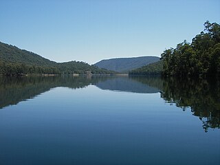
Dartmouth Dam is a large rock-fill embankment dam with an uncontrolled chute spillway across the Mitta Mitta, Gibbo, and Dart rivers, the Morass Creek and a number of small tributaries. The dam is located near Mount Bogong in the north-east of the Australian state of Victoria. The dam's purpose includes irrigation, the generation of hydro-electric power, water supply and conservation. The impounded reservoir is called Dartmouth Reservoir, sometimes called Lake Dartmouth. The Dartmouth Power Station, a hydro-electric power station that generates power to the national grid, is located near the dam wall.

Mitta Mitta River, a perennial river and a direct tributary of the Murray River within the Murray–Darling basin, is located in the Alpine district of Victoria, Australia.

Hume Dam, formerly the Hume Weir, is a major dam across the Murray River downstream of its junction with the Mitta River in the Riverina region of New South Wales, Australia. The dam's purpose includes flood mitigation, hydro-power, irrigation, water supply and conservation. The impounded reservoir is called Lake Hume, formerly the Hume Reservoir. It is a gated concrete gravity dam with four earth embankments and twenty-nine vertical undershot gated concrete overflow spillways.

The Goulburn River, a major inland perennial river of the Goulburn Broken catchment, part of the Murray-Darling basin, is located in the Alpine, Northern Country/North Central, and Southern Riverina regions of the Australian state of Victoria. The headwaters of the Goulburn River rise in the western end of the Victorian Alps, below the peak of Corn Hill before descending to flow into the Murray River near Echuca, making it the longest river in Victoria at 654 kilometres (406 mi). The river is impounded by the Eildon Dam to create Lake Eildon, the Eildon Pondage, the Goulburn Weir and Waranga Basin.

Kiewa River, a perennial river that is part of the Murray catchment within the Murray-Darling basin, is located in the Alpine bioregion, in the Australian state of Victoria.

Bright is a town in northeastern Victoria, Australia, 319 metres above sea level at the southeastern end of the Ovens Valley. At the 2021 census, Bright had a population of 2,620. It is located in the Alpine Shire local government area.

The Ovens River, a perennial river of the north-east Murray catchment, part of the Murray-Darling basin, is located in the Alpine and Hume regions of the Australian state of Victoria.

The Broken River, a minor inland perennial river of the Goulburn Broken catchment, part of the Murray–Darling basin, is located in the Alpine and Northern Country/North Central regions of the Australian state of Victoria. The headwaters of the Broken River rise in the western slopes of the Victorian Alps, near Bald Hill and descend to flow into the Goulburn River near Shepparton. The river is impounded by the Nillahcootie Dam to create Lake Nillahcootie and Benalla Dam to create Lake Benalla.
The Rubicon River, an inland perennial river of the Goulburn Broken catchment, part of the Murray-Darling basin, is located in the lower South Eastern Highlands bioregion and Northern Country/North Central regions of the Australian state of Victoria. The headwaters of the Rubicon River rise on the western slopes of the Victorian Alps and descend to flow into the Goulburn River.
The Morses Creek, is a perennial stream of the North-East Murray catchment of the Murray-Darling basin, is located in the Alpine region of Victoria, Australia. It flows from the northern slopes of the Mount Buffalo National Park in the Australian Alps, joining with the Ovens River at Bright.
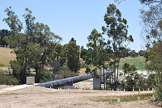
The William Hovell Dam is a rock and earth-fill embankment dam with a flip bucket chute spillway across the King River, located in the Hume region of Victoria, Australia. The purposes of the dam are for irrigation and the generation of hydroelectricity. The impounded reservoir is called Lake William Hovell

The Buckland River, a perennial river of the North-East Murray catchment of the Murray-Darling basin, is located in the Alpine region of Victoria, Australia. It flows from the eastern slopes of the Buffalo Range in the Australian Alps, joining with the Ovens River at Porepunkah.
The Yea River, an inland perennial river of the Goulburn Broken catchment, part of the Murray-Darling basin, is located in the lower South Eastern Highlands bioregion and Northern Country/North Central regions of the Australian state of Victoria.

The Bundara River, a perennial river of the North-East Murray catchment of the Murray-Darling basin, is located in the East Gippsland and Alpine regions of Victoria, Australia.
The Buffalo River, a perennial river of the North-East Murray catchment of the Murray-Darling basin, is located in the Alpine region of Victoria, Australia. It flows from the eastern slopes of the Buffalo Range in the Australian Alps, joining with the Ovens River west of Myrtleford.

The Catherine River, a perennial river of the North-East Murray catchment of the Murray-Darling basin, is located in the Alpine region of Victoria, Australia. It flows Northwards in the Alpine National Park in the Australian Alps, joining with the Buffalo River in remote national park territory.

The Dandongadale River, a perennial river of the North-East Murray catchment of the Murray-Darling basin, is located in the Alpine region of Victoria, Australia. It flows from the northern slopes of the Alpine National Park in the Australian Alps, joining with the Buffalo River in remote national park territory.
The Rose River, a perennial river of the North-East Murray catchment of the Murray-Darling basin, is located in the Alpine region of Victoria, Australia. It flows from the northern slopes of the Mount Buffalo National Park in the Australian Alps, joining with the Dandongadale River in remote national park territory.
Mount Buggery is a mountain located in the Wangaratta Rural City local government area, near Abbeyard above the Buffalo River in the alpine region of Victoria, Australia.
The Royston River, an inland perennial river of the Goulburn Broken catchment, part of the Murray-Darling basin, is located in the lower South Eastern Highlands bioregion and Northern Country/North Central regions of the Australian state of Victoria. The headwaters of the Royston River rise on the western slopes of the Victorian Alps and descend to flow into the Rubicon River.

