
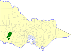
The Shire of Moyne is a local government area in the Barwon South West region of Victoria, Australia, located in the south-western part of the state. It covers an area of 5,481 square kilometres (2,116 sq mi) and in June 2018 had a population of 16,887. It includes the towns of Port Fairy, Koroit, Mortlake, Macarthur, Peterborough, Caramut, Ellerslie, Framlingham, Garvoc, Hawkesdale, Kirkstall, Panmure, Mailors Flat, Purnim, Wangoom and Woolsthorpe. It also entirely surrounds the City of Warrnambool, a separate local government area. It was formed in 1994 from the amalgamation of the Shire of Belfast, Shire of Minhamite, Borough of Port Fairy, and parts of the Shire of Mortlake, Shire of Warrnambool, Shire of Dundas, Shire of Mount Rouse and Shire of Hampden.

Rydalmere(formerly "Field of Mars") is a suburb of Sydney, in the state of New South Wales, Australia. Rydalmere is approximately 21 kilometres west of the Sydney central business district in the local government area of the City of Parramatta. Rydalmere is part of the Greater Western Sydney region.
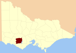
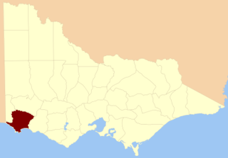
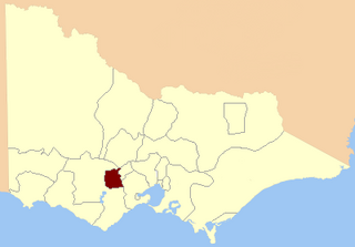
The Shire of Dundas was a local government area about 300 kilometres (186 mi) west of Melbourne, the state capital of Victoria, Australia. The shire covered an area of 3,464.39 square kilometres (1,337.6 sq mi), and existed from 1857 until 1994.
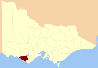
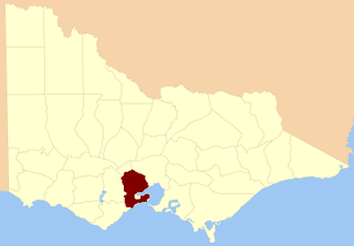
The City of Hamilton was a local government area about 300 kilometres (186 mi) west of Melbourne, the state capital of Victoria, Australia. The city covered an area of 20.64 square kilometres (8.0 sq mi), and existed from 1859 until 1994. Its area was surrounded by the Shire of Dundas.

Dundas was a historical mining locality, mineral field and railway location on the western foothills of the West Coast Range in Western Tasmania. It is now part of the locality of Zeehan.

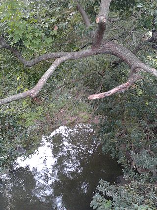
The Wannon River, a perennial river of the Glenelg Hopkins catchment, is located in the Western District of Victoria, Australia.
The County of Hampden is one of the 37 counties of Victoria which are part of the cadastral divisions of Australia, used for land titles. The county is in the Western District of Victoria bounded by Lake Corangamite in the east and the Hopkins River in the west. In the north and south the county was bounded approximately by the existing roads, now the Glenelg Highway and the Princes Highway. Larger towns include Terang and Skipton. The county was proclaimed in 1849.
The County of Heytesbury is one of the 37 counties of Victoria which are part of the cadastral divisions of Australia, used for land titles. The county is in the Western District of Victoria bounded by the Gellibrand River in the east and the Hopkins River in the west. In the north, the county was bounded approximately by the existing road, now the Princes Highway. Larger towns include Camperdown and Cobden. The county was proclaimed in 1849.

The County of Dundas is one of the 37 counties of Victoria which are part of the cadastral divisions of Australia, used for land titles. The county is in the Western District of Victoria bounded by the Glenelg River in the west and north, by a line from Casterton to Penshurst in the south, and by the eastern edge of the Grampians in the east. Larger towns include Hamilton, Casterton and Coleraine. The county was proclaimed in 1849.
The County of Normanby in Victoria, is one of the 37 counties of Victoria which are part of the cadastral divisions of Australia, used for land titles. The county is in the Western District of Victoria bounded by the Glenelg River in the west and the Eumeralla River in the east, by a line through Casterton and Hamilton in the north, and by Bass Strait to the south. Larger towns include Hamilton, Portland and Heywood. The county was proclaimed in 1853, but it was known earlier since the 1849 proclamation of Follett County and Dundas County referred to its boundaries.
Vineyard Creek, a northern tributary of the Parramatta River, is a creek in Sydney, Australia.
The Electoral district of Normanby was an electoral district in the Legislative Assembly of Victoria, it covered an area from the South Australian border to Portland Bay.
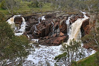
The Nigretta Falls, previously known as the Upper Wannon Falls, are waterfalls located in the Southern Grampians Shire, approximately 16 kilometres (9.9 mi) west of Hamilton, Victoria, Australia. The falls are fed by the Wannon River that has its head waters in the Grampians mountains.

The Wannon Falls are a punchbowl waterfall located in the Southern Grampians Shire, approximately 19 kilometres (12 mi) west of Hamilton, in western Victoria, Australia. The falls are fed by the Wannon River that has its head waters in the Grampians mountains.

The electoral district of Wimmera was an electoral district of the Legislative Assembly in the Australian state of Victoria.
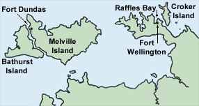
Fort Wellington was the name of a short-lived British settlement established in 1827 at Raffles Bay, on the northern side of the Cobourg Peninsula of what is now the Northern Territory of Australia, which was abandoned in 1829. It was the second of a series of four such abortive settlement attempts in Australia's Top End, the first being Fort Dundas (1824–1828) on Melville Island, the third Fort Victoria or Victoria Settlement, at Port Essington (1838–1849) on the Cobourg Peninsula, and the fourth at Escape Cliffs (1864–1867) near the mouth of the Adelaide River.

Dundas was an electoral district of the Legislative Assembly in the Australian state of Victoria from 1856 to 1976. It covered a region of western Victoria and consisted of the counties of Dundas and Follett.
North Grenville was an electoral district of the Legislative Assembly in the Australian state of Victoria from 1856 to 1859. It was bordered on the east by the Yarrowee River and included an area south of Ballarat. The short-lived, rural district of North Grenville was one of the initial districts of the first Victorian Legislative Assembly, 1856.
South Grant was an electoral district of the Legislative Assembly in the Australian state of Victoria from 1856 to 1877.

The Electoral district of Wimmera was one of the original sixteen electoral districts of the old unicameral Victorian Legislative Council of 1851 to 1856. Victoria was a colony in Australia at the time.
