| Regions of Gippsland |
|---|


East Gippsland is the eastern region of Gippsland, Victoria, Australia covering 31,740 square kilometres (14%) of Victoria. It has a population of 80,114. [1]
| Regions of Gippsland |
|---|
East Gippsland is the eastern region of Gippsland, Victoria, Australia covering 31,740 square kilometres (14%) of Victoria. It has a population of 80,114. [1]
The Shire of East Gippsland, also called Far East Gippsland, covers two-thirds (66%) of East Gippsland's area and holds half (50%) of its population. [2] The Shire of East Gippsland is confusingly also referred to simply as East Gippsland. It excludes the Shire of Wellington (Central Gippsland). This article (currently) refers mainly to "Far East Gippsland".
East Gippsland's major towns include, from west to east, Bairnsdale (the largest town and administrative centre), Paynesville, Lakes Entrance, Orbost and Mallacoota. Smaller, but significant, towns in the more mountainous northern areas include Ensay, Swifts Creek, Omeo, and Buchan.
East Gippsland extends from the western watershed of the Mitchell and Thomson River catchments east and north to the New South Wales border. Rugged terrain makes farming difficult, even with fertilisers.
The major industry is often considered to be forestry, which provides less than 1 percent of employment for the region. [3] The East Gippsland Regional Forest Agreement (RFA) was signed by Commonwealth and Victorian governments on 3 February 1997, and is Australia's first RFA. [4] It covers a region similar, but not identical to the East Gippsland Shire. It sets aside 5,811 km² from logging, an increase of 1.3% over pre-RFA reserves. [5] Central Gippsland is covered by the Gippsland RFA (signed 31 March 2000), which covers an area similar to the Shire of Wellington, and places 7,805 km² in reserves. [5]
Logging of native forests has caused sustained controversy in East Gippsland, particularly due to the unique species found in areas east of the Snowy River, and the contentious public debate surrounding native forest, particularly old-growth, harvesting. This is despite managed forest having a mitigation effect in climate change. [6]
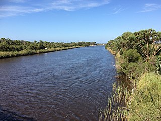
The major river basins of the Mitchell, Tambo and Nicholson drain into the Gippsland Lakes, which in turn empty into the sea through an artificially maintained opening at Lakes Entrance.

The area is a major tourist destination, especially for watersports, and is noted for its mild climate. The Great Alpine Road leads north from Bairnsdale into the Australian Alps via Swifts Creek and Omeo, and onto the major ski resorts of Dinner Plain and Mount Hotham. This area is also very popular for bushwalking in the summer. The Buchan district is popular with tourists for its limestone caves. Further east, the Snowy River and several smaller stream catchments, including the Thurra, Wingan, Genoa, Bemm River and Cann River, enter the Tasman Sea.
More than 17,000 km² of East Gippsland is public land with 2,680 km² being national parks, two of the largest being Snowy River National Park and Errinundra National Park. Both are remote and inaccessible, but they are otherwise entirely different. Snowy River National Park features dramatic gorges and powerful rapids formed by the descent of the Snowy River. Apart from gorges and southern slopes, this park is in a rain-shadow area forming the southern border of the Monaro Tableland. Consequently, many species more typical of inland New South Wales and Victoria are found here. Errinundra National Park is much wetter - inaccessible from June to October in most years - and features some of the most ancient forests in Australia, a matter of controversy as employment in the remote areas east of the Snowy is mainly dependent upon timber milling.[ citation needed ] Croajingolong National Park between Marlo and Mallacoota features extensive coastal heathlands and tea tree scrub, as well as the only major area of warm temperate rainforest in Victoria. The 4,193 km² of privately owned land is mainly red gum plains, coastal plains, mountain plateaux and fertile river valleys.
In April and November 2022, East Gippsland Water got fined $9,246 for discharging over 30 million litres of wastewater into Macleod Morass wetland which made the facility exceed its licence given by EPA Victoria and failing to comply with their regulatory notice obligation. [7] [8]

Gippsland is a rural region that makes up the southeastern part of Victoria, Australia, mostly comprising the coastal plains to the rainward (southern) side of the Victorian Alps. It covers an elongated area of 41,556 km2 (16,045 sq mi) located further east of the Shire of Cardinia between Dandenong Ranges and Mornington Peninsula, and is bounded to the north by the mountain ranges and plateaus/highlands of the High Country, to the southwest by the Western Port Bay, to the south and east by the Bass Strait and the Tasman Sea, and to the east and northeast by the Black–Allan Line.

The Shire of East Gippsland is a local government area in Gippsland, Victoria, Australia, located in the eastern part of the state. It covers an area of 20,940 square kilometres (8,080 sq mi) and in June 2018 had a population of 46,818.

Orbost is a historic early settlers town in the Shire of East Gippsland, Victoria, 375 kilometres (233 mi) east of Melbourne and 235 kilometres (146 mi) south of Canberra where the Princes Highway crosses the Snowy River. It is about 16 kilometres (10 mi) from the surf and fishing seaside town of Marlo on the coast of Bass Strait and 217 km drive to Hotham Alpine Resort. Orbost is the service centre for the primary industries of beef, dairy cattle and sawmilling. More recently, tourism has become an important and thriving industry, being the major town close to several national parks that are between the east access to either the surf or the snow, including the famous Snowy River National Park, Alpine National Park, Errinundra National Park, Croajingolong National Park and Cape Conran Coastal Park.

The electoral district of Gippsland East is an electoral district of the Victorian Legislative Assembly. It covers most of eastern Victoria and includes the towns of Bairnsdale, Lakes Entrance, Orbost, Omeo, Maffra and Heyfield. Gippsland East is the state's third largest electorate in area and covers 27,544 square kilometres.
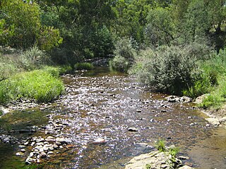
The Suggan Buggan River is a perennial river of the Snowy River catchment, located in the Alpine region of the Australian state of Victoria.
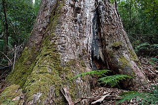
The Brown Mountain forest is located in East Gippsland, Victoria (Australia), and is notable for containing large tracts of old growth forest, including over fifty shining gum trees estimated to be over 300 years old.
The Timbarra River is a perennial river of the Mitchell River catchment, located in the East Gippsland region of the Australian state of Victoria.
The Brodribb River is a perennial river of the Snowy River catchment, located in the East Gippsland region of the Australian state of Victoria.

The Bonang River is a perennial river of the Snowy River catchment, located in the Alpine region of the Australian state of Victoria.

The Buchan River is a perennial river of the Snowy River catchment, located in the Alpine region of the Australian state of Victoria.
The Errinundra River is a perennial river of the Bemm River catchment, located in the East Gippsland region of the Australian state of Victoria.
The Combienbar River is a perennial river of the Bemm River catchment, located in the East Gippsland region of the Australian state of Victoria.
The Ada River is a perennial river of the Bemm River catchment, located in the East Gippsland region of the Australian state of Victoria.
The McKenzie River is a perennial river of the Bemm River catchment, located in the East Gippsland region of the Australian state of Victoria.
The Jack River is a perennial river of the Snowy River catchment, located in the East Gippsland region of the Australian state of Victoria.
The Big River is a perennial river of the Snowy River catchment, located in the East Gippsland region of the Australian state of Victoria.
The Saint Patricks River is a perennial river of the Snowy River catchment, located in the East Gippsland region of the Australian state of Victoria.
The Rich River is a perennial river of the Snowy River catchment, located in the East Gippsland region of the Australian state of Victoria.
The Murrindal River is a perennial river of the Snowy River catchment, located in the East Gippsland region of the Australian state of Victoria.
The Back River is a perennial river of the Mitchell River catchment, located in the Alpine region of the Australian state of Victoria.
Avoiding deforestation in Australia is a large, immediate and perishable opportunity to reduce GHG emissions.