
Sale is a city situated in the Gippsland region of the Australian state of Victoria. It had an estimated urban population of 15,135 as of June 2019.

Gippsland is a rural region of Victoria, Australia, located in the south-eastern part of that state. It covers an area of 41,556 square kilometres (16,045 sq mi), and lies to the east of the eastern suburbs of Greater Melbourne, to the north of Bass Strait, to the west of the Tasman Sea, to the south of the Black-Allan Line that marks part of the Victorian/New South Wales border, and to the east and southeast of the Great Dividing Range that lies within the Hume region and the Victorian Alps. Gippsland is generally broken down into the East Gippsland, South Gippsland, West Gippsland, and the Latrobe Valley statistical divisions.
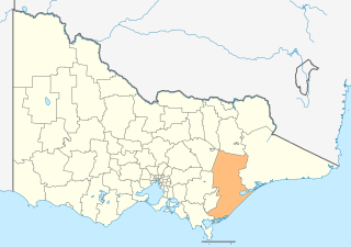
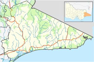
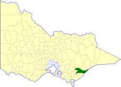
The Shire of Wellington is a local government area in Victoria, Australia, located in the eastern part of the state. It covers an area of 10,817 square kilometres (4,176 sq mi) and in June 2018 had a population of 44,019.

Heyfield is a town in Victoria, Australia, with a population of 1,993. It is 206 kilometres (128 mi) east of Melbourne, in the Shire of Wellington local government area. Located on the Thomson River, Heyfield is a gateway to the Victorian High Country.

Maffra is a town in Victoria, Australia, 220 kilometres (140 mi) east of Melbourne. It is in the Shire of Wellington local government area. It relies mainly on dairy farming and other agriculture, and is the site of one of Murray-Goulburn Cooperative's eight processing plants in Victoria. Maffra is a detour off the Princes Highway and is near Sale, Stratford, Newry, Tinamba, Heyfield and Rosedale. At the 2016 census, Maffra had a population of 4,316.

The Gippsland Lakes are a network of lakes, marshes and lagoons in east Gippsland, Victoria, Australia covering an area of about 354 square kilometres (137 sq mi). The largest of the lakes are Lake Wellington, Lake King and Lake Victoria. The lakes are collectively fed by the Avon, Thomson, Latrobe, Mitchell, Nicholson and Tambo rivers.
Lakes Entrance is a seaside resort and fishing port in eastern Victoria, Australia. It is situated approximately 320 kilometres (200 mi) east of Melbourne, near a managed, artificial channel connecting the Gippsland Lakes to Bass Strait. At the 2016 census, Lakes Entrance had a population of 4,810.
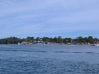
Paynesville is a tourist/holiday resort town in the Gippsland region of Victoria, Australia. At the 2016 census, Paynesville had a population of 3,480. The town is located 293 kilometres (182 mi) by road east of the state capital, Melbourne. It is known as the boating capital of Victoria.

The Avon River is a perennial river of the West Gippsland catchment, located in the West Gippsland region, of the Australian state of Victoria. The Avon, forms an important part of the Latrobe sub-catchment, draining the south eastern slopes of the Great Dividing Range, to form the Gippsland Lakes.

Stratford is a town on the Avon River in Victoria, Australia, 232 kilometres (144 mi) east of Melbourne on the Princes Highway in Shire of Wellington. At the 2006 census, Stratford had a population of 1950. The town services the local regional community and travellers on the Princes Highway. Stratford's principal industries are dairying, sheep, cattle and horse breeding and vegetable crops. The town has numerous coffee shops and cafes, a cellar door for a local winery, Design Gallery, model railway shop, a pub, parks and playgrounds for car travellers to break their journey.
East Gippsland is the eastern region of Gippsland, Victoria, Australia covering 31,740 square kilometres (14%) of Victoria. It has a population of 80,114.

Glenmaggie is a town in Victoria, Australia, located on the shores of Lake Glenmaggie, in the Shire of Wellington. At the 2016 census, Glenmaggie and the surrounding area had a population of 277.

Boisdale is a town in the Central Gippsland region of Victoria, Australia, located on Briagolong Road, north of Maffra, in the Shire of Wellington. At the 2006 census, Boisdale and the surrounding area had a population of 275.

The Gunai language is an Australian aboriginal dialect cluster of the Gunai people in Gippsland in south-east Victoria. Bidhawal (Birrdhawal) was either a divergent dialect or a closely related language.

The Latrobe River is a perennial river of the West Gippsland catchment, located in the West Gippsland region of the Australian state of Victoria. The Latrobe River and its associated sub-catchment is an important source for the Gippsland Lakes, draining the south eastern slopes of the Great Dividing Range.
The Shire of Rosedale was a local government area stretching between the towns of Traralgon and Sale in the Gippsland region of Victoria, Australia. The shire covered an area of 2,276.6 square kilometres (879.0 sq mi), and existed from 1869 until 1994.

The Perry River is a perennial river of the West Gippsland catchment, located in the Gippsland region of the Australian state of Victoria.

Seaspray is a small coastal town in Victoria, Australia, in the Gippsland region of the state. The town is located alongside the Ninety Mile Beach about 10 kilometres (6.2 mi) off the South Gippsland Highway in the Shire of Wellington, 242 kilometres (150 mi) east of the state capital, Melbourne. At the 2016 census, Seaspray had a population of 322.
Wy Yung is a town in Victoria, Australia, located on Great Alpine Road, in the Shire of East Gippsland near Bairnsdale. The town was named after the local indigenous meaning for wild duck.

Flynn is a locality in Victoria, Australia, situated on the border of the City of Latrobe and Shire of Wellington. In the 2016 census, Flynn had a population of 180.
