Sebastian Inlet State Park is a Florida state park located 10 miles south of Melbourne Beach and 6 miles north of Vero Beach in Florida. The park lies on both sides of the Sebastian Inlet, which forms the boundary between Brevard and Indian River counties. The land for the park was acquired by the state of Florida in 1971. In 2010, it was the second most visited state park in Florida.

Inverloch is a seaside town in Victoria, Australia. It is 143 kilometres (89 mi) south east of Melbourne via the South Gippsland Highway on the Bass Highway in the Bass Coast Shire of Gippsland. Known originally for the calm waters of Anderson Inlet, it is now also known for the discovery of Australia's first dinosaur bone.

Yarram is a town in the Shire of Wellington, Victoria, Australia, located in the southeast of Gippsland. At the 2016 census, the population of the town was 2,135.Nearby towns include Welshpool, Alberton and Foster.

Noosa Heads is a coastal town and suburb in the Shire of Noosa, Queensland, Australia. It is a popular holiday destination. In the 2021 census, the suburb of Noosa Heads had a population of 5,120 people.

The Ninety Mile Beach is a sandy stretch of beach on the south-eastern coastline of the East Gippsland region of Victoria in Australia. The beach faces Bass Strait and backs the Gippsland Lakes. The beach is just over 151 kilometres (94 mi) in length, running north-eastward from a spit near Port Albert to the man-made channel at Lakes Entrance.

The Gippsland Lakes are a network of coastal lakes, marshes and lagoons in East Gippsland, Victoria, Australia covering an overall area of about 354 km2 (137 sq mi) between the rural towns of Lakes Entrance, Bairnsdale and Sale. The largest of the lakes are Lake Wellington, Lake King and Lake Victoria. The lakes are collectively fed by the Avon, Thomson, Latrobe, Mitchell, Nicholson and Tambo Rivers, and drain into Bass Strait through a short canal about 2 km (1.2 mi) southwest of Lakes Entrance town centre.

Lakes Entrance is a town in the Shire of East Gippsland, Victoria, Australia. It is situated approximately 320 kilometres (200 mi) east of Melbourne, near a managed, artificial channel connecting the Gippsland Lakes to Bass Strait. At the 2016 census, Lakes Entrance had a population of 4,810.
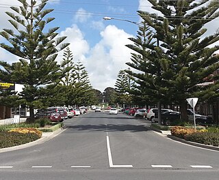
Wonthaggi is a seaside town located 132 kilometres (82 mi) south east of Melbourne via the South Gippsland and Bass highways, in the Bass Coast Shire of Gippsland, Victoria, Australia. Known originally for its coal mining, it is now the largest town in South Gippsland, a regional area with extensive tourism, beef and dairy industries.

Elliston is a small coastal town in the Australian state of South Australia on the west coast of Eyre Peninsula, 169 km northwest of Port Lincoln and 641 km west of Adelaide. The township is located on Waterloo Bay. At the 2021 census, Elliston had a population of 333.

Fort Pierce Inlet State Park, a 340-acre (1.4 km2) part of the Florida State Park system, is located just north of the Fort Pierce Inlet, on North Hutchinson Island, near Fort Pierce. It consists of beaches, dunes and a coastal hammock between the Atlantic Ocean and the waters of Tucker Cove, an indentation of the Indian River Lagoon.

Cape Paterson is a cape and seaside village located near the town of Wonthaggi, 132 kilometres (82 mi) south-east of Melbourne via the South Gippsland and Bass Highways, in the Bass Coast Shire of Gippsland, Victoria, Australia. Known originally for the discovery of coal by William Hovell in 1826, it is now extremely popular for its beaches and rockpool and at the 2011 census, it had a population of 718.
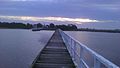
Loch Sport is a town situated on the Ninety Mile Beach and Lake Victoria in Central Gippsland, eastern Victoria, Australia. At the 2016 census, it had a permanent resident population of 814. This is an increase of 125 from the 2011 census.
Snake Island is a sand island, located in Corner Inlet in the Gippsland region of Victoria, Australia. It has an area of 35-square-kilometre (14 sq mi) and is the largest island in Corner Inlet. Snake Island lies within the Nooramunga Marine and Coastal Park and is part of a complex of barrier islands that protect a large marine embayment from the pounding waves of Bass Strait. The Aboriginal Gunai name for the island is Negima.

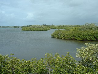
The Corner Inlet is a 600-square-kilometre (230 sq mi) bay located 200 kilometres (120 mi) south-east of Melbourne in the South Gippsland region of Victoria, Australia. Of Victoria's large bays it is both the easternmost and the warmest. It contains intertidal mudflats, mangroves, salt marsh and seagrass meadows, sheltered from the surf of Bass Strait by a complex of 40 sandy barrier islands, the largest of which are Snake, Sunday and Saint Margaret Islands.
Saint Margaret Island lies in Corner Inlet, in the Gippsland region of Victoria, Australia. It lies at the eastern end of the Nooramunga Marine and Coastal Park, close to Ninety Mile Beach.

Anderson Inlet, sometimes incorrectly referred to as Andersons Inlet, is a shallow and dynamic estuary in South Gippsland, Victoria, Australia where the Tarwin River enters Bass Strait. It forms a 2,400-hectare (5,900-acre) almost enclosed bay next to the town of Inverloch, for which it provides a popular and protected beach. At low tide its intertidal mudflats provide important feeding habitat for migratory waders. It is also an important area for recreational fishing. It is named after Samuel Anderson pioneer explorer the first European to settle in the area.
Woodside Beach is a locality in the Shire of Wellington, Victoria, Australia. It is approximately 10 km from the town of Woodside, and can be reached by the Woodside Beach Road. Areas of interest surrounding Woodside Beach include Balloong Natural Interest Reserve, Jack Smith Lake and McLoughlins Beach.

Golden Beach is a town situated on the Ninety Mile Beach in Gippsland Victoria. The beaches there offer long distances for walking and fishing, but are not patrolled. It has kangaroos on the golf course, a playground near the shops and a lookout deck near the ocean beach. There are many nearby wildlife reserves which are sanctuaries for water birds and other species. Seaspray and Loch Sport are nearby settlements which are slightly more developed with eating places and a caravan park.
The Wilsons Promontory Marine National Park is a protected marine national park located in the South Gippsland region of Victoria, Australia. The 15,500-hectare (38,000-acre) marine park is situated off the southern tip of Wilsons Promontory and extends along the coastline from Norman Bay, near Tidal River, in the west around the southern tip of the promontory to Cape Wellington in the east. It extends offshore to the Glennie and Anser groups of offshore islands.

Seaspray is a town in the Gippsland region of Victoria, Australia. The town is located on the Ninety Mile Beach, about 10 kilometres (6.2 mi) off the South Gippsland Highway, in the Shire of Wellington, 242 kilometres (150 mi) east of the state capital, Melbourne.