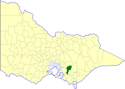
The Shire of Baw Baw is a local government area in Victoria, Australia, in the eastern part of the state. It covers an area of 4,031 square kilometres (1,556 sq mi) and at the 2016 Census had a population of approximately 48,500.

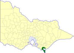
The Shire of South Gippsland is a local government area in Victoria, Australia, located in the south-eastern part of the state. It covers an area of 3,305 square kilometres (1,276 sq mi) and, at the 2016 Census had a population of over 28,000.

Mirboo North is a town in Victoria, Australia, located 155 kilometres (96 mi) east of Melbourne, with a population of 1,697. It is in the South Gippsland Shire local government area.

Drouin is a town in the West Gippsland region, 90 kilometres (56 mi) east of Melbourne, in the Australian state of Victoria. Its local government area is the Shire of Baw Baw. The town is supposedly named after a Frenchman who invented a chlorination process for the extraction of ore or an Aboriginal word meaning "north wind". New housing developments have accelerated the town's residential growth in recent years. As at the 2016 census, Drouin had a population of 11,887 people.

Yarragon is a small town in the Baw Baw Shire in the West Gippsland region of Victoria, Australia. The town lies on the Princes Highway and the main Gippsland Railway line approximately halfway between the major towns of Warragul and Moe. Hills of the Strzelecki Ranges rise over 500 metres immediately to the south of the town providing a spectacular backdrop, while the Moe River and the lowlands lie to the north and east. Mount Worth at 515m above sea level is the highest near peak to the south in the Mount Worth State Park 16 kilometres SSW of Yarragon. Mount Baw Baw at 1563m in the Baw Baw Ranges as part of the Great Dividing Range to the north is approximately 85 kilometres NNE of Yarragon. The township sits at approximately 88 metres above sea level. At the 2006 census, Yarragon had a population of 1131.

The Latrobe River is a perennial river of the West Gippsland catchment, located in the West Gippsland region of the Australian state of Victoria. The Latrobe River and its associated sub-catchment is an important source for the Gippsland Lakes, draining the south eastern slopes of the Great Dividing Range.

The Ellinbank and District Football League is an Australian rules football League, based in the West Gippsland region of Victoria for smaller towns and villages in the regions of Baw Baw, South Gippsland and Cardinia.
The Shire of Buln Buln was a local government area about 95 kilometres (59 mi) east-southeast of Melbourne, the state capital of Victoria, Australia. The shire covered an area of 1,259 square kilometres (486.1 sq mi), and existed from 1878 until 1994.

The Shire of Korumburra was a local government area located about 115 kilometres (71 mi) southeast of Melbourne, the state capital of Victoria, Australia. The shire covered an area of 613.8 square kilometres (237.0 sq mi), and existed from 1891 until 1994.

The Shire of Woorayl was a local government area about 130 kilometres (81 mi) southeast of Melbourne, the state capital of Victoria, Australia. The shire covered an area of 1,245.79 square kilometres (481.0 sq mi), and existed from 1888 until 1994.
The Shire of South Gippsland was a local government area about 170 kilometres (106 mi) south-southeast of Melbourne, the state capital of Victoria, Australia. The shire covered an area of 1,432.26 square kilometres (553.0 sq mi), and existed from 1894 until 1994.
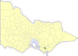
The Shire of Mirboo was a local government area about 160 kilometres (99 mi) southeast of Melbourne, the state capital of Victoria, Australia. The shire covered an area of 255.07 square kilometres (98.5 sq mi), and existed from 1894 until 1994.

The Shire of Narracan was a local government area about 120 kilometres (75 mi) east-southeast of Melbourne, the state capital of Victoria, Australia. The shire covered an area of 2,300 square kilometres (888.0 sq mi), and existed from 1878 until 1994.

The City of Morwell was a local government area about 150 kilometres (93 mi) east-southeast of Melbourne, the state capital of Victoria, Australia. The city covered an area of 670.81 square kilometres (259.0 sq mi), and existed from 1892 until 1994.
The Noojee railway line is a closed railway line in Victoria, Australia. Branching off from the Gippsland line at Warragul station, it was built to service the timber industry in the upper Latrobe River area, transporting timber as well as providing a general goods and passenger service to townships in the area. The final section of the line between Neerim South and Noojee traversed increasingly hilly terrain and featured a number of large timber trestle bridges. Extensively and repeatedly damaged by bushfires over the years, the line was closed in the 1950s and dismantled. The last remaining large trestle bridge on the line has been preserved and has become a popular local tourist attraction.

The Electoral district of Alberton was an electoral district of the Legislative Assembly in the Australian colony of Victoria, located in the south-east of the then-colony.

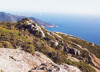
The Tarwin River is a perennial river of the West Gippsland catchment, located in the South Gippsland region of the Australian state of Victoria. The Tarwin River is the primary river system within South Gippsland Shire and has a catchment area of approximately 1,500 square kilometres (580 sq mi), predominantly rural with small pockets of residential land use. It flows south from the Strzlecki Ranges and discharges in the eastern reaches of Anderson Inlet, a shallow estuary connected to Bass Strait.
Gippsland Province was an electorate of the Victorian Legislative Council from November 1882 until 2006. It was based in the Gippsland region of Victoria, Australia.