
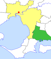
The Shire of Cardinia is a local government area in Victoria, Australia, in the south-east of Melbourne between Western Port and the Yarra Ranges on the outskirts of Melbourne. It has an area of 1,283 square kilometres, and had a population of 107,120 in June 2018.

The Bass Coast Shire is a local government area in Victoria, Australia, located in the southeastern part of the state. It covers an area of 866 square kilometres (334 sq mi) and in June 2018 had a population of 35,327. It includes the towns of Bass, Cape Paterson, Cape Woolamai, Corinella, Coronet Bay, Cowes, Inverloch, Kilcunda, Lang Lang, Newhaven, Rhyll, San Remo, Summerlands and Wonthaggi as well as the historic locality of Krowera. It also includes the popular tourist destination Phillip Island. It was formed in 1994 from the amalgamation of the Shire of Bass, Shire of Phillip Island, Borough of Wonthaggi, parts of the Shire of Woorayl, Shire of Korumburra and City of Cranbourne.

Warneet is a village in Victoria, Australia, 68 km (42 mi) south-east of Melbourne's Central Business District, located within the City of Casey local government area. Warneet recorded a population of 565 at the 2021 census.

Western Port, commonly but unofficially known as Western Port Bay, is a large tidal bay in southern Victoria, Australia, opening into Bass Strait. It is the second largest bay in the state. Geographically, it is dominated by two large islands; French Island and Phillip Island. At the time it was renamed, its position was west of other known ports and bays, but Western Port has become something of a misnomer as it lies just to the east of the larger Port Phillip and the city of Melbourne. It is visited by Australian fur seals, whales and dolphins, as well as many migratory waders and seabirds. It is listed under the Ramsar Convention as a wetland of international significance.

The Division of La Trobe is an Australian electoral division in the state of Victoria. It is a semi-urban electorate extending from the outer south-eastern suburbs of Melbourne to the westernmost areas of Gippsland. It fully incorporates the suburbs of Beaconsfield, Officer and Pakenham, the majority of Clyde North and Harkaway, and eastern portions of Berwick. The division also covers towns beyond the metropolitan area such as Beaconsfield Upper, Bunyip, Cockatoo, Emerald, Garfield, Gembrook, Koo Wee Rup, Lang Lang, Nar Nar Goon and Pakenham Upper.
The South Gippsland railway line is a partially closed railway line in Victoria, Australia. It was first opened in 1892, branching from the Orbost line at Dandenong, and extending to Port Albert. Much of it remained open until December 1994. Today, only the section between Dandenong and Cranbourne remains open for use. The section of the line from Nyora to Leongatha was used by the South Gippsland Tourist Railway until it ceased operations in 2016. The section from Nyora to Welshpool, with extension trail to Port Welshpool and a portion of the former line at Koo Wee Rup, have been converted into the Great Southern Rail Trail.

The electoral district of Bass is one of the electoral districts of Victoria, Australia, for the Victorian Legislative Assembly. It covers an area of 1,358 square kilometres (524 sq mi) south east of Melbourne, stretching from the satellite suburb of Clyde through rural areas to the coast at Inverloch and Phillip Island. It includes the suburbs and towns of Bass, Cape Paterson, Clyde, Corinella, Cowes, Grantville, Inverloch, Kilcunda, Koo Wee Rup, Lang Lang, Pearcedale, Rhyll, San Remo, Tooradin, Ventnor and Wonthaggi. It lies within the Eastern Victoria Region of the upper house, the Legislative Council.
The South Gippsland Railway was a tourist railway located in South Gippsland, Victoria, Australia. It controlled a section of the former South Gippsland railway line between Nyora and Leongatha, and operated services from Leongatha to Nyora, via Korumburra, the journey taking about 65 minutes.
Koo Wee Rup was a railway station on the South Gippsland line in South Gippsland, Victoria, Australia. The station operated until the closure of the line between Cranbourne Station and Leongatha Station in July 1993. The station remains partly intact with the platform and goods shed intact, however the track one kilometre on each side of the station platform has been dismantled, and replaced by a concrete pathway for bicycles and recreational use. Koo Wee Rup was also the junction of the branch line to Strzelecki. The establishment of the pathway has effectively removed any likelihood that the railway will be rehabilitated. It can also be seen as being the start of a rail trail on the railway reserve, stretching back to Cranbourne, which will block future rail transport options for people in Cranbourne East, Clyde, and surrounding areas.
Nyora is a railway station on the former South Gippsland line in South Gippsland, Victoria, Australia.
Woodleigh was a railway station on the Wonthaggi line, in Victoria, Australia.
Heath Hill was a railway station on the Strzelecki railway line in South Gippsland, Victoria, Australia. The station was opened on 29 June 1922, and closed on 7 August 1941 following flooding of the Lang Lang River, which resulted in damages to one of the four trestle bridges over the river, after which the line was closed back to Yannathan station.
The Ellinbank and District Football Netball League (EDFNL), formerly known as the Ellinbank & District Football League (EDFL), is an Australian rules football and netball league, based in the West Gippsland region of Victoria for smaller towns and villages in the regions of Baw Baw, South Gippsland and Cardinia.

The Shire of Pakenham was a local government area about 60 kilometres (37 mi) southeast of Melbourne, the state capital of Victoria, Australia. The shire covered an area of 874 square kilometres (337.5 sq mi), and existed from 1862 until 1994.
The City of Cranbourne was a local government area about 45 kilometres (28 mi) southeast of Melbourne, the state capital of Victoria, Australia. The city covered an area of 755 square kilometres (291.5 sq mi), and existed from 1860 until 1994. It was notable for being the last local government area to be declared a city prior to the large-scale amalgamations of 1994 – its former designation was the Shire of Cranbourne.
Koo Wee Rup North is a bounded rural locality in Victoria, Australia, 62 kilometres (39 mi) south-east of Melbourne's central business district, located within the Shire of Cardinia local government area. Koo Wee Rup North recorded a population of 47 at the 2021 census.

Bayles is a bounded rural locality in Victoria, Australia, 75 kilometers south-east of Melbourne's Central Business District, located within the Shire of Cardinia local government area. Bayles recorded a population of 445 at the 2021 census.
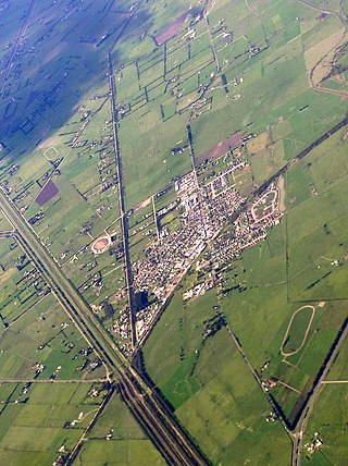
Koo Wee Rup is a town and satellite suburb in Victoria, Australia, 63 km south-east of Melbourne's Central Business District, located within the Shire of Cardinia local government area. Built on former marshland now converted to market gardens, Koo Wee Rup recorded a population of 4,047 at the 2021 census.

The Koo-Wee-Rup Swamp was a large freshwater swamp located to the south east of Melbourne, Victoria. It drained an area of West Gippsland, with several waterways including Cardinia Creek and the Bunyip River.
The West Gippsland Football Netball Competition (WGFNC) is an Australian rules football and netball league in the West Gippsland region of Victoria, Australia. The competition comprises four grades of football and six grades of netball.
