
Boundary Islet, historically known as North East Islet, is a 2-hectare (4.9-acre) islet in the Hogan Island Group of Bass Strait, at a latitude of 39°12′ S, about 56 kilometres (35 mi) east of the southernmost point of mainland Victoria. The islet straddles the maritime border of the Australian states of Victoria and Tasmania, hence the name.
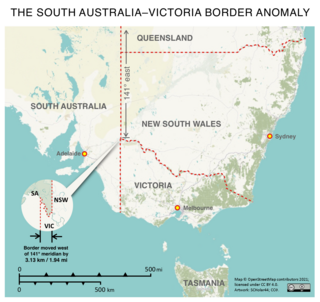
The border between the Australian states of South Australia and Victoria was established in 1836 by imperial letters patent "as the 141st degree meridian of longitude east of Greenwich". In 1836 the land in what is now called Victoria was part of the colony of New South Wales, the original Victorian border was drawn between the colonies of South Australia and New South Wales. An error came about in establishing the position of the 141st meridian, and more than 75 years and a protracted legal dispute passed before the precise placement of the border was settled, resulting in the forfeiture of more than 1,300 km2 (500 sq mi) of territory from South Australia to Victoria.

Haddon Corner is a heritage-listed site in Tanbar, Shire of Barcoo, Queensland, Australia. It is in outback Channel Country at South-West Queensland, on the border corner with South Australia. It was added to the Queensland Heritage Register on 9 November 2012.

The Port Phillip District was an administrative division of the Colony of New South Wales from 9 September 1836 until 1 July 1851, when it was separated from New South Wales and became the Colony of Victoria.

Murray County was one of the original Nineteen Counties in New South Wales and is now one of the 141 Lands administrative divisions of New South Wales. It included the area which is now part of Canberra and as far north as Lake George and Yass. It was originally bounded on the west by the Murrumbidgee River, on the east by the Shoalhaven River and on the north by the Yass River. A large area of the county was transferred to the Commonwealth government in 1909 in the Seat of Government Acceptance Act to make part of the Australian Capital Territory, along with land in Cowley County. Since then, the ACT border is now part of the western boundary. Part of the ACT border is determined by property boundaries in the Parish of Keewong, in the County of Murray; specifically the southern end of portions 177, 218, 211, 36, and 38. This is mentioned in the Seat of Government Acceptance Act of 1909.
The 141st meridian east of Greenwich is a line of longitude that extends from the North Pole across the Arctic Ocean, Asia, the Pacific Ocean, Australasia, the Indian Ocean, the Southern Ocean, and Antarctica to the South Pole.
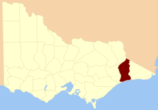
The County of Tambo is one of the 37 counties of Victoria which are part of the cadastral divisions of Australia, used for land titles. It is located in eastern Gippsland, between the Tambo River in the west, and the Snowy River in the east. It includes Lakes Entrance. Some time earlier maps showed proposed counties of Abinger and Combermere occupying the area.
The County of Tatchera is one of the 37 counties of Victoria which are part of the cadastral divisions of Australia, used for land titles. It is located to the south of the Murray River, and to the south west of Swan Hill, with its western boundary at 143°E, and part of the southern boundary at 36°S.
The County of Karkarooc is one of the 37 counties of Victoria which are part of the cadastral divisions of Australia, used for land titles. It is located to the south of the Murray River, with its western boundary at 142°E, and its eastern boundary at 143°E. Its southern boundary is on the 36°S parallel. Lake Tyrrell is located near the eastern boundary. Mildura is located near the north-western edge.
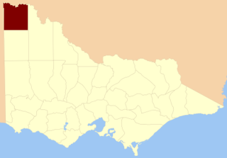
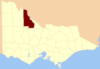
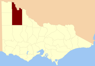
The County of Millewa is one of the 37 counties of Victoria which are part of the cadastral divisions of Australia, used for land titles. It is located to the south of the Murray River, at the north-western corner of Victoria, with the South Australian border to the west. This border was originally intended to be at the 141st meridian of longitude, but because of the South Australia-Victoria border dispute it is several miles to the west of it. The southern boundary of the county is at 35°S, and the eastern at 142°E. The name is also used for the region.
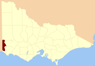
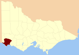
The County of Follett is one of the 37 counties of Victoria which are part of the cadastral divisions of Australia, used for land titles. It comprises a strip in the far southwest of the state bounded by the Glenelg River to the east, South Australia to the west and Elderslie Creek to the north beyond Casterton. No larger towns are contained within its boundaries. The county was proclaimed in 1849.

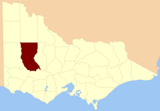
The County of Lowan is one of the 37 counties of Victoria which are part of the cadastral divisions of Australia, used for land titles. The northern boundary of the county is at 36°S. Larger towns include Dimboola, Edenhope and Kaniva. The county was proclaimed in 1871 together with the other counties of the Wimmera Land District.
The County of Borung is one of the 37 counties of Victoria which are part of the cadastral divisions of Australia, used for land titles. The northern boundary of the county is at 36°S. At the north its western boundary is 142°E, its eastern boundary is 143°E. Larger urban centres include Dimboola, Warracknabeal, Horsham and Stawell. The county was proclaimed in 1871 together with the other counties of the Wimmera Land District.
The Electoral district of Normanby was an electoral district in the Legislative Assembly of Victoria, it covered an area from the South Australian border to Portland Bay.
Today South Australia's land borders are defined to the west by the 129° east longitude with Western Australia, to the north by the 26th parallel south latitude with the Northern Territory and Queensland and to the east by 141° east longitude with Queensland, New South Wales and Victoria; however, this is not where all borders are actually marked on the ground.
Today the Northern Territory's land borders are defined to the west by the 129° east longitude with Western Australia, to the south by the 26th parallel south latitude with South Australia and to the east by 138° east longitude with Queensland; however, this is not where all borders are actually marked on the ground.

MacCabe Corner is the name given to the south-west corner of the state of New South Wales, Australia. It is located 82 kilometres (51 mi) west of the town of Wentworth, New South Wales, on a bend of the Murray River. MacCabe Corner is named for Francis MacCabe, a surveyor who did considerable work exploring and mapping New South Wales, in particular the rivers of the Murray-Darling basin.

Cameron Corner Survey Marker is a heritage-listed survey marker in the locality of Cameron Corner, Shire of Bulloo, Queensland, Australia. The survey marker is at the border corner of South-West Queensland with New South Wales and South Australia; it was established in 1880. It was added to the Queensland Heritage Register on 9 November 2012.

Poeppel Corner Survey Marker is a heritage-listed survey marker at Poeppel Corner on the border corner of Queensland, South Australia and Northern Territory. In Queensland it is with the locality of Birdsville in the Shire of Diamantina. It was added to the Queensland Heritage Register on 9 November 2012.

Queensland is the north-eastern state of Australia and has land borders with three other Australian states and territories: New South Wales, South Australia and Northern Territory. To the north of Queensland is the Torres Strait separating the Australian mainland from Papua New Guinea. To the east of Queensland is the Coral Sea, part of the Pacific Ocean. There are many islands off the Queensland coast which form part of the state of Queensland.


