Murray River National Park is a protected area in South Australia located between 180 kilometres (110 mi) and 240 km (150 mi) north east of the Adelaide city centre, lying along the Murray River. The national park is classified as an IUCN Category VI protected area. As of 2022 the national park comprises more than 14,879 ha, and includes a vast network of Murray River wetlands and floodplains.
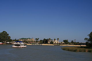
Renmark is a town in South Australia's rural Riverland area, and is located 254 km (157.83 mi) northeast of Adelaide, on the banks of the River Murray. The Sturt Highway between Adelaide and Sydney runs through the town; Renmark is the last major town encountered in South Australia when driving this route. It is a few kilometres west of the SA–Victoria and SA–NSW borders. It is 31 m (101.71 ft) above sea level.

The Riverland is a region of South Australia. It covers an area of 9,386 square kilometres (3,624 sq mi) along the River Murray from where it flows into South Australia from New South Wales and Victoria downstream to Blanchetown. The major town centres are Renmark, Berri, Loxton, Waikerie, Barmera and Monash, and many minor townships. The population is approximately 35,000 people.

Kingston On Murray is a town on the south bank of the Murray River in the Riverland region of South Australia. Its name is ultimately derived from Charles Kingston who was Premier of South Australia from 1893 to 1899. At the 2006 census, the town had a population of 257.

The District Council of Loxton Waikerie is a local government area in the Murray Mallee region of South Australia. The council seat lies at Loxton, while it maintains a branch office at Waikerie.
Paringa is a small town in the Riverland of South Australia. Paringa is famous for its vineyards, almond, citrus and stone fruit orchards, and the steel bridge with a span that can be raised to allow houseboats and paddlesteamers to pass underneath and across the Murray River to Renmark.

The Renmark Paringa Council is a local government area located adjacent to the Victorian border, in the Riverland, South Australia. The area is known for its various fruit production, and is heavily dependent on the River Murray as a water source. The council seat is at Renmark.
The District Council of Waikerie was a local government area in South Australia from 1914 to 1997, centring on the town of Waikerie.
The District Council of Loxton was a local government area in South Australia from 1910 to 1997, centring on the town of Loxton.

Paruna is a town in eastern South Australia. The town is located on the Browns Well Highway, where it crosses the former Barmera railway line, 237 kilometres (147 mi) east of the state capital, Adelaide.
The Barmera railway line was the second railway built to develop the Murray Mallee region of South Australia, in 1913. It followed the success of the Pinnaroo railway line in 1906. Both lines branched east from Tailem Bend to the north of the main Melbourne–Adelaide railway. The Brown's Well line was the more northerly, and extended into country which had not been developed much before the railway, partly due to the absence of any viable transport route for produce. The original terminus of the Brown's Well railway was at Meribah, not far from the Victorian border.
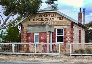
The District Council of Brown's Well was a local government area in South Australia from 1916 to 1997. The name stemmed from the Brown's Well pastoral station, which was located near the council seat of Paruna. Meetings were also held on a regular basis in the institute at Alawoona, which was the district's major centre.
The Village Settlements were communes set up by the South Australian government under Part VII of the Crown Lands Amendment Act 1893, a scheme intended to mitigate the effects of the depression that was affecting the Colony. It followed the New Zealand Village Settlements Act and similar schemes in Canada and New South Wales, and concurrently with Victoria. It followed the "blockers" scheme espoused by George W. Cotton.
Wonuarra is a locality southeast of Paringa in the east end of the South Australian Riverland region. The locality is east of the Sturt Highway between Paringa and Yamba and extends from the highway to the state border.
Murtho is a locality in South Australia. It is northeast of Renmark and Paringa. It is bounded by the Murray River on its north and west sides and the Victorian border on the east.
The District Council of Swan Reach was a local government area in the Murraylands of South Australia from 1888 to 1933.

The County of Albert is one of the 49 cadastral counties of South Australia on the east banks of the River Murray. It was proclaimed by Governor Richard MacDonnell in 1860 and named for Albert, Prince Consort of Queen Victoria.
Ramco Point Conservation Park is a protected area located in the Australian state of South Australia in the locality of Sunlands about 150 kilometres (93 mi) north-east of the state capital of Adelaide and about 7 kilometres (4.3 mi) north-west of the municipal seat of Waikerie.
Pike River is a locality in the Australian state of South Australia located in the Riverland in the state’s east on the southern side of the Murray River about 210 kilometres (130 mi) north-east of the state capital of Adelaide and about 9 kilometres (5.6 mi) south-east of the municipal seat of Renmark.
Pooginook is a locality in the Australian state of South Australia located in the state’s east about 167 kilometres (104 mi) north-east of the state capital of Adelaide and about 60 kilometres (37 mi) north-west of the municipal seat in Loxton.
