County of Burra

Last updated

Burra
South Australia
Burra Town Hall.jpg
Burra Town Hall in the Hundred of Kooringa
Australia South Australia location map.svg
Red pog.svg
Burra
Coordinates 33°38′S139°18′E / 33.63°S 139.30°E / -33.63; 139.30
Established1851 [1]
Area5,400 square kilometres (2,080 sq mi) [2]
LGA(s) Mid Murray Council
Regional Council of Goyder
Unincorporated area [2]
Region Murray and Mallee [2] [3]
Yorke and Mid North [2] [4]
Lands administrative divisions around Burra:
Victoria Kimberley
Victoria
Stanley
Burra Young
Light Light
Eyre
Young
FootnotesCoordinates [2]
Adjoining counties [5]

County of Burra is a cadastral unit located in the Australian state of South Australia which covers land located in the state’s east associated with the town of Burra. It was proclaimed in 1851 by Governor Young and named after the town of Burra.

Contents

Description

The County of Burra covers part of South Australia to the east of the northern end of the Mount Lofty Ranges and to the north-west of the ‘great bend’ in the Murray River and with the town of Burra being located midway along its western boundary. [1] [5] [6]

History

The County of Burra was proclaimed by Henry Edward Fox Young, the fifth Governor of South Australia on 7 August 1851. [1] The county was named after the then government town of Burra. [2] The following thirteen hundreds were proclaimed within the County between the years 1851 and 1881- Apoinga in 1851, Baldina in 1875, Bright in 1875, Bundey in 1878, Hallett in 1860, King in 1878, Kingston in 1860, Kooringa in 1851, Lindley in 1881, Maude under the name of Schomburgk in 1880, Mongolata in 1875, Rees in 1879, and Tomkinson in 1879. [7]

Constituent hundreds

Description of layout of the hundreds

The hundreds located within the County of Burra are laid out in four rows (from north to south) as follows: [5]

Hundred of Apoinga

The Hundred of Apoinga ( 33°53′16″S138°58′37″E / 33.887820°S 138.976920°E / -33.887820; 138.976920 (Hundred of Apoinga) ) was proclaimed by Governor Young on 7 August 1851. It covers an area of 240 square kilometres (91 sq mi) and its name is considered to be “corruption of ‘appinga’” which is the name of the Aboriginal tribe “which inhabited the area.”. The Hundred of Apoinga includes the localities of Apoinga , Koonoona , Emu Downs, the southern part of Burra, northern part of Brady Creek and the Emu Flats northwestern corner of Robertstown. [8]

Hundred of Baldina

The Hundred of Baldina ( 33°43′04″S139°06′15″E / 33.717860°S 139.104120°E / -33.717860; 139.104120 (Hundred of Baldina) ) was proclaimed by Governor Musgrave on 30 December 1875. It covers an area of 240 square kilometres (93 sq mi). It includes the locality of Baldina, the northern half of the locality of Worlds End and the a section of the locality of Burra Eastern Districts. [9]

Hundred of Bright

The Hundred of Bright ( 33°52′49″S139°06′43″E / 33.880180°S 139.111990°E / -33.880180; 139.111990 (Hundred of Bright) ) was proclaimed by Governor Musgrave on 17 June 1875. It covers an area of 240 square kilometres (93 sq mi) and was named after Henry Edward Bright, a South Australian politician. It includes the locality of Bright, the southern half of the locality of Worlds End, the north-western part of the locality of Robertstown and the north-western corner of the locality of Geranium Plains. [10]

Hundred of Bundey

The Hundred of Bundey ( 33°53′18″S139°16′16″E / 33.888430°S 139.271110°E / -33.888430; 139.271110 (Hundred of Bundey) ) was proclaimed on 21 November 1878. It covers an area of 310 square kilometres (118 sq mi) and was named after William Henry Bundey, a South Australian politician. It includes the locality of Bundey and the north-eastern corner of the locality of Geranium Plains. [11]

Hundred of Hallett

The Hundred of Hallett ( 33°24′05″S138°57′47″E / 33.401260°S 138.963030°E / -33.401260; 138.963030 (Hundred of Hallett) ) was proclaimed by Governor MacDonnell on 23 February 1860. It covers an area of 350 square kilometres (135 sq mi) and is reported as being either named after a pastoralist, Alfred Hallett of Wandilla Station, or after John Hallett, a South Australian politician. It includes the majority of the localities of Hallett and Mount Bryan East, the southern part of the locality of Ulooloo and the north-western corner of the locality of Collinsville. [12]

Hundred of King

The Hundred of King ( 33°43′28″S139°15′45″E / 33.724330°S 139.2625°E / -33.724330; 139.2625 (Hundred of King) ) was proclaimed by Governor Jervois on 31 October 1878. It covers an area of 310 square kilometres (118 sq mi) and was named after Thomas King, a South Australian politician. It is entirely contained within the modern locality of Burra Eastern Districts. [13]

Hundred of Kingston

The Hundred of Kingston ( 33°32′50″S138°56′46″E / 33.547110°S 138.945980°E / -33.547110; 138.945980 (Hundred of Kingston) ) was proclaimed by Governor MacDonnell on 23 February 1860. It covers an area of 230 square kilometres (87 sq mi) and was named after George Strickland Kingston, a South Australian politician. It includes the locality of Mount Bryan, the south-western part of the locality of Mount Bryan East and much of the north-eastern part of the locality of Burra. [14]

Hundred of Kooringa

The Hundred of Kooringa ( 33°42′42″S138°57′38″E / 33.711560°S 138.9605°E / -33.711560; 138.9605 (Hundred of Kooringa) ) was proclaimed by Governor Young on 3 March 1881 7/08/1851. It covers an area of 250 square kilometres (98 sq mi) and its name is reported as being derived from the Aboriginal name for land on which the government town of Burra was located. It includes the central part of the modern locality of Burra and the south-western tip of the locality of Mount Bryan. [15]

Hundred of Lindley

The Hundred of Lindley ( 33°53′13″S139°36′47″E / 33.887070°S 139.612930°E / -33.887070; 139.612930 (Hundred of Lindley) ) was proclaimed by Governor Jervois on 3 March 1881. It covers an area of 300 square kilometres (115 sq mi) and was named after John Lindley, an English botanist and horticulturalist. It shares exactly the same boundaries as the modern locality of Lindley. [16]

Hundred of Maude

The Hundred of Maude ( 33°53′08″S139°26′33″E / 33.8856°S 139.442610°E / -33.8856; 139.442610 (Hundred of Maude) ) which was originally proclaimed as the Hundred of Schomburgk on 16 December 1880, covers an area of 300 square kilometres (115 sq mi). The original naming was to honour Moritz Richard Schomburgk, a director of the Adelaide Botanic Gardens. It was one of places to be renamed during World War I as it was "of enemy origin". The Hundred of Koerabko was first proposed as a replacement name but was not accepted without a reason being given. It finally named after Frederick Stanley Maude, a British general of World War I on 10 January 1918. A proposal submitted in 1983 to reinstate Schomburgk as the hundred’s name was not approved by the Geographical Names Board. It shares exactly the same boundaries as the modern locality of Maude. [17] [18]

Hundred of Mongolata

The Hundred of Mongolata ( 33°33′06″S139°06′19″E / 33.5518°S 139.1054°E / -33.5518; 139.1054 (Hundred of Mongolata) ) was proclaimed by Governor Musgrave on 30 December 1875. It covers an area of 240 square kilometres (93 sq mi) and its name is reported as being derived from an Aboriginal word. It includes the locality of Mongolata, a north-eastern part of the locality of Burra, the south-eastern part of the locality of Mount Bryan East and the north-western part of the locality of Burra Eastern Districts. [19]

Hundred of Rees

The Hundred of Rees ( 33°33′24″S139°16′00″E / 33.556550°S 139.266760°E / -33.556550; 139.266760 (Hundred of Rees) ) was proclaimed by Governor Jervois on 18 September 1879. It covers an area of 260 square kilometres (101 sq mi) and was named after Rowland Rees, a South Australian politician. It is entirely contained within the modern locality of Burra Eastern Districts. [20]

Hundred of Tomkinson

The Hundred of Tomkinson ( 33°24′08″S139°12′51″E / 33.402090°S 139.214130°E / -33.402090; 139.214130 (Hundred of Tomkinson) ) was proclaimed by Governor Jervois on 18 September 1879. It covers an area of 430 square kilometres (167 sq mi) and was named after Samuel Tomkinson, a South Australian politician. It includes the vast majority of the locality of Collinsville and a small eastern part of the locality of Mount Bryan East. [21]

See also

Related Research Articles

<span class="mw-page-title-main">Regional Council of Goyder</span> Local government area in South Australia

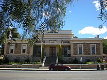
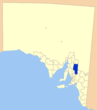
The Regional Council of Goyder is a local government area located in the Mid North region of South Australia. The council area is reliant on agriculture as a mainstay of its economy, with manufacturing and tourism also becoming prominent. The council seat is at Burra. A branch office is at Eudunda.

<span class="mw-page-title-main">County of Hindmarsh</span> Cadastral in South Australia

The County of Hindmarsh is one of the 49 cadastral counties of South Australia. It was proclaimed by Governor George Grey in 1842 and named for Governor John Hindmarsh.

<span class="mw-page-title-main">Mongolata, South Australia</span> Town in South Australia

Mongolata is a rural locality in the Mid North region of South Australia, situated in the Regional Council of Goyder. The modern locality was established in August 2000, when boundaries were formalised for the "long established local name".

Burra Eastern Districts is a rural locality in the Mid North region of South Australia, situated in the Regional Council of Goyder. It was established in August 2000, when boundaries were formalised for the "long established local name".

<span class="mw-page-title-main">County of Carnarvon (South Australia)</span> Cadastral in South Australia

County of Carnarvon is a cadastral unit located in the Australian state of South Australia which covers the full extent of Kangaroo Island. It was proclaimed in 1874 by Governor Musgrave in response to the demand for agriculture land on Kangaroo Island.

<span class="mw-page-title-main">County of Fergusson</span> Cadastral in South Australia

County of Fergusson is a cadastral unit located in the Australian state of South Australia which spans Yorke Peninsula south of Price. It was proclaimed in 1869 by Governor Fergusson after whom the county was named.

The District Council of Apoinga was a local government area in South Australia from 1873 to 1932.

<span class="mw-page-title-main">County of Hamley</span> Cadastral in South Australia

The County of Hamley is a cadastral unit located in the Australian state of South Australia covers land located in the state's east north of the Murray River, bordering New South Wales and Victoria. It was proclaimed in 1869 by Governor Fergusson and named after Francis Hamley.

<span class="mw-page-title-main">County of Young</span> Cadastral in South Australia

County of Young is a cadastral unit located in the Australian state of South Australia covers land located in the state’s east on the north side of the Murray River. It was proclaimed in 1860 by Governor MacDonnell and named after his predecessor, Governor Young. It has been partially divided in the following sub-units of hundreds – Markaranka, Parcoola, Pooginook and Stuart.

The District Council of Burra was a local government area in South Australia from 1872 to 1935.

<span class="mw-page-title-main">County of Musgrave</span> Cadastral in South Australia

The County of Musgrave is a cadastral unit in the Australian state of South Australia that covers land on the west coast of Eyre Peninsula. It was proclaimed on 22 June 1876 and named after Anthony Musgrave, the Governor of South Australia from 9 June 1876 to 29 January 1877.

Baldina is a rural locality in the Mid North region of South Australia, situated in the Regional Council of Goyder. It was established in August 2000, when boundaries were formalised for the "long established local name".

County of Manchester is a cadastral unit located in the Australian state of South Australia that covers land both located in the north-east of Eyre Peninsula and to the peninsula's north. It was proclaimed in 1891 and named after George Montagu, 6th Duke of Manchester who was the father-in-law of the Earl of Kintore GCMG, the Governor of South Australia at the time.

<span class="mw-page-title-main">County of Le Hunte</span> Cadastral in South Australia

County of Le Hunte is a cadastral unit located in the Australian state of South Australia that covers land located in the centre of Eyre Peninsula. It was proclaimed in 1908 and named after George Le Hunte who was the Governor of South Australia from July 1903 to February 1909.

<span class="mw-page-title-main">County of Buxton</span> Cadastral in South Australia

County of Buxton is a cadastral unit located in the Australian state of South Australia that covers land located in the centre of Eyre Peninsula. It was proclaimed in 1896 and named after Thomas Buxton who was the Governor of South Australia from 29 October 1895 to 29 March 1899. It has been divided into thirteen sub-divisions known as hundreds, with the most recent being created in 1928.

<span class="mw-page-title-main">County of Jervois</span> Cadastral in South Australia

The County of Jervois is a cadastral unit in the Australian state of South Australia that covers land on the east coast of the Eyre Peninsula. It was proclaimed on 24 January 1878 and named after William Jervois, the Governor of South Australia from October 1877 to January 1883.

<span class="mw-page-title-main">County of Taunton</span> Cadastral in South Australia

County of Taunton is a cadastral unit located in the Australian state of South Australia on land on the east coast of Lake Torrens about 160 kilometres (99 mi) from the city of Port Augusta. It was proclaimed in 1877 and named after Lord Taunton who was the Secretary for the Colonies from 1855 to 1858. It has been partially divided in the following sub-units of hundreds – Bunyeroo, Carr, Edeowie, Nilpena, Oratunga and Parachilna.

<span class="mw-page-title-main">County of Herbert</span> Cadastral in South Australia

County of Herbert is a cadastral unit located in the Australian state of South Australia that covers land to the east of the Flinders Ranges about 55 kilometres (34 mi) north-east of the town of Peterborough. It was proclaimed in 1877 and named after a prominent man of the time with either a title or a surname containing the name ‘Herbert’. It has been partially divided in the following sub-units of hundreds – Cavenagh, Coglin, Minburra, Nackara, Paratoo and Waroonee.

<span class="mw-page-title-main">County of Kimberley</span> Cadastral in South Australia

County of Kimberley is a cadastral unit located in the Australian state of South Australia that covers land to the east of the Flinders Ranges about 45 kilometres (28 mi) east of the town of Peterborough. It was proclaimed in 1871 and named after John Wodehouse, 1st Earl of Kimberley, a British Secretary of State for the Colonies. It has been partially divided in the following sub-units of hundreds – Gumbowie, Hardy, Ketchowla, Parnaroo, Terowie and Wonna.

<span class="mw-page-title-main">County of Hanson</span> Cadastral in South Australia

County of Hanson is a cadastral unit located in the Australian state of South Australia that covers land in the Flinders Ranges immediately east of the town of Hawker. It was proclaimed on 20 July 1877 and is named after Sir Richard Davies Hanson who served as Premier, Administrator and Chief Justice of South Australia. It has been partially divided in the following sub-units of hundreds – Adams, Arkaba, French, Moralana and Warcowie.

References

  1. 1 2 3 "Proclamation" (PDF). The South Australian Government Gazette. 1860. Government of South Australia: 550. 7 August 1851. Retrieved 15 August 2016.
  2. 1 2 3 4 5 6 "Search result for "County of Burra (CNTY)" (Record no SA0011215) with the following layers selected - "Local Government Areas", "Counties", "Hundreds" and "Government Regions"". Property Location Browser. Government of South Australia. Archived from the original on 7 December 2015. Retrieved 15 August 2016.
  3. "Murray and Mallee SA Government region" (PDF). The Government of South Australia. Retrieved 9 August 2016.
  4. "Yorke and Mid North SA Government region" (PDF). The Government of South Australia. Retrieved 17 August 2016.
  5. 1 2 3 "HUNDRED MAP Series Index Map" (PDF). Department of Environment and Heritage, Government of South Australia. December 2008. Retrieved 16 November 2015.
  6. "Search result for "County of Burra (CNTY)" with the following datasets selected - "Counties"". Location SA Map Viewer. Government of South Australia. Retrieved 17 August 2016.
  7. Leadbeater, Maureen (2014). "Counties & Hundreds of South Australia". FamilyHistorySA. Retrieved 9 August 2016.
  8. "Search result for "Hundred of Apoinga (HD)" (Record no SA0001792) with the following layers selected - "Suburbs and Localities", "Counties" and "Hundreds"". Property Location Browser. Government of South Australia. Archived from the original on 7 December 2015. Retrieved 16 August 2016.
  9. "Search result for 'Hundred of Baldina (HD)' (Record no SA0004313) with the following layers selected - 'Suburbs and Localities', 'Counties' and 'Hundreds'". Property Location Browser. Government of South Australia. Archived from the original on 7 December 2015. Retrieved 16 August 2016.
  10. "Search result for 'Hundred of Bright (HD)' (Record no SA0009548) with the following layers selected - 'Suburbs and Localities', 'Counties' and 'Hundreds'". Property Location Browser. Government of South Australia. Archived from the original on 7 December 2015. Retrieved 16 August 2016.
  11. "Search result for 'Hundred of Bundey (HD)' (Record no SA0010792) with the following layers selected - 'Suburbs and Localities', 'Counties' and 'Hundreds'". Property Location Browser. Government of South Australia. Archived from the original on 7 December 2015. Retrieved 16 August 2016.
  12. "Search result for 'Hundred of Hallett (HD)' (Record no SA0029014) with the following layers selected - 'Suburbs and Localities', 'Counties' and 'Hundreds'". Property Location Browser. Government of South Australia. Archived from the original on 7 December 2015. Retrieved 16 August 2016.
  13. "Search result for 'Hundred of King (HD)' (Record no SA0036725) with the following layers selected - 'Suburbs and Localities', 'Counties' and 'Hundreds'". Property Location Browser. Government of South Australia. Archived from the original on 7 December 2015. Retrieved 16 August 2016.
  14. "Search result for 'Hundred of Kingston (HD)' (Record no SA0058351) with the following layers selected - 'Suburbs and Localities', 'Counties' and 'Hundreds'". Property Location Browser. Government of South Australia. Archived from the original on 7 December 2015. Retrieved 16 August 2016.
  15. "Search result for 'Hundred of Kooringa (HD)' (Record no SA0037617) with the following layers selected - 'Suburbs and Localities', 'Counties' and 'Hundreds'". Property Location Browser. Government of South Australia. Archived from the original on 7 December 2015. Retrieved 16 August 2016.
  16. "Search result for 'Hundred of Lindley (HD)' (Record no SA0039512) with the following layers selected - 'Suburbs and Localities', 'Counties' and 'Hundreds'". Property Location Browser. Government of South Australia. Archived from the original on 7 December 2015. Retrieved 16 August 2016.
  17. "Search result for 'Hundred of Maude (HD)' (Record no SA0043516) with the following layers selected - 'Suburbs and Localities', 'Counties' and 'Hundreds'". Property Location Browser. Government of South Australia. Archived from the original on 7 December 2015. Retrieved 16 August 2016.
  18. "Search result for "Hundred of Schomburgk (HD)" (Record no SA0060527) with the following layers selected - 'Suburbs and Localities', 'Counties' and 'Hundreds'". Property Location Browser. Government of South Australia. Archived from the original on 7 December 2015. Retrieved 16 August 2016.
  19. "Search result for 'Hundred of Mongolata (HD)' (Record no SA0045628) with the following layers selected - 'Suburbs and Localities', 'Counties' and 'Hundreds'". Property Location Browser. Government of South Australia. Archived from the original on 7 December 2015. Retrieved 16 August 2016.
  20. "Search result for 'Hundred of Rees (HD)' (Record no SA0058351) with the following layers selected - 'Suburbs and Localities', 'Counties' and 'Hundreds'". Property Location Browser. Government of South Australia. Archived from the original on 7 December 2015. Retrieved 16 August 2016.
  21. "Search result for 'Hundred of Tomkinson (HD)' (Record no SA0065810) with the following layers selected - 'Suburbs and Localities', 'Counties' and 'Hundreds'". Property Location Browser. Government of South Australia. Archived from the original on 7 December 2015. Retrieved 16 August 2016.