
Whyalla is a city in South Australia. It was founded as "Hummocks Hill", and was known by that name until 1916. It is the fourth most populous city in the Australian state of South Australia after Adelaide, Mount Gambier and Gawler and along with Port Pirie and Port Augusta is one of the three towns to make up the Iron Triangle. As of June 2018, Whyalla had an urban population of 21,742, having declined at an average annual rate of -0.75% year-over-year over the preceding five years. It is a seaport located on the east coast of the Eyre Peninsula and is known as the "Steel City" due to its integrated steelworks and shipbuilding heritage. The port of Whyalla has been exporting iron ore since 1903.
Lincoln Highway is a highway in South Australia which links the cities of Port Augusta and Port Lincoln located on the east coast of Eyre Peninsula over a distance of 315 kilometres. Lincoln Highway - along with Flinders Highway - presents an alternative but somewhat longer coastal route between Ceduna and Port Augusta, compared to the more direct route along Eyre Highway. It is designated route B100.

The Eyre Peninsula is a triangular peninsula in South Australia. It is bounded by the Spencer Gulf on the east, the Great Australian Bight on the west, and the Gawler Ranges to the north.
Iron Knob is a town in the Australian state of South Australia on the Eyre Peninsula immediately south of the Eyre Highway. At the 2006 census, Iron Knob and the surrounding area had a population of 199. The town obtained its name from its proximity to large deposits of iron ore, most notably Iron Monarch which outcropped prominently from the relatively flat, surrounding landscape.
Arrium was an Australian mining and materials company, employing nearly 10,000 workers, that went into voluntary administration in 2016 with debts of more than $2 billion. In 2017 it was acquired by British-owned Liberty House Group.

The City of Whyalla is a local government area in South Australia, located at the north-east corner of the Eyre Peninsula. It was established in 1970, replacing the town commission, which had been running the town previously. The district is mostly industrial, with many large companies having factories in the city.
The Hundred of Cultana is a cadastral unit of hundred located on the upper Eyre Peninsula in South Australia just north of Whyalla. It is one of the seven Hundreds of the County of York. It was proclaimed in 1940 by Governor Malcolm Barclay-Harvey and named for a Cultana Hill, the term Cultana deriving from a local indigenous term.

The Whyalla Steelworks is a fully integrated steelworks and the only manufacturer of rail in Australia. Iron ore is mined in the Middleback Range to feed the steelworks, resulting in the distribution of finished steel products of over 90 different grades. It occupies a 1,000 ha site on the shore of False Bay, Spencer Gulf and is the largest employer in Whyalla, South Australia.

Point Lowly is the tip of a small peninsula north north-east of Whyalla in the Upper Spencer Gulf region of South Australia. The wider peninsula is shared by a combination of defence, industrial, residential, recreational and tourism interests. Port Bonython lies immediately to the north-west and is marked for future industrial expansion, driven by anticipated growth in the State's mining industry. The icons of the peninsula are the historic Point Lowly Lighthouse and the mass breeding aggregation of Australian giant cuttlefish which occurs inshore each winter.
Cultana is a locality on the northeastern part of Eyre Peninsula in South Australia. It is much larger than the original locality, and includes the Australian Army's Cultana Training Area. It includes the former Baxter Detention Centre which operated from 2002 to 2007. It spans the Lincoln Highway and Iron Knob to Whyalla Road, as well as being bordered by the Eyre Highway east of Iron Knob.

The Cultana Training Area is an Australian Army training area on northeastern Eyre Peninsula in South Australia between Port Augusta, Whyalla and Iron Knob. It includes the former Baxter Detention Centre. The training area was enlarged in 2014 to accommodate training needs of 1st Brigade and 7th Battalion, Royal Australian Regiment. The lease of the land includes provisions for mining access. It also has an Indigenous land use agreement with the Barngarla people.
Middleback Range is a locality in the Australian state of South Australia located in the north east corner of Eyre Peninsula to the south-west of the city of Whyalla and extending from the coastline of Spencer Gulf in the east to the west side of the southern end of the Middleback Range in the west.
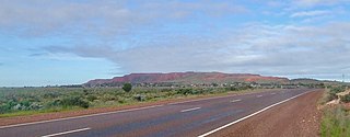
The Middleback Range is a mountain range on the eastern side of Eyre Peninsula in South Australia. The Middleback Range has been a source of iron ore for over a century, particularly to feed the Whyalla Steelworks. Mines in the region were first developed by BHP from the 1890s and are now owned and operated by Liberty House Group.
Commissariat Point is a locality in the Australian state of South Australia located on the east coast of the Eyre Peninsula overlooking Spencer Gulf about 270 kilometres north north-west of the state capital of Adelaide and about 11 kilometres south of the municipal seat in Port Augusta.
Whyalla-Cowleds Landing Aquatic Reserve is a marine protected area in the Australian state of South Australia located in the waters of Spencer Gulf adjoining the east coast of Eyre Peninsula. About 20 kilometres (12 mi) south of Whyalla, it includes land in the localities of Cowleds Landing and Middleback Range which is subject to tidal inundation. It was declared in 1984 to protect "the mangrove-seagrass communities and associated fish nursery areas".
County of Manchester is a cadastral unit located in the Australian state of South Australia that covers land both located in the north-east of Eyre Peninsula and to the peninsula's north. It was proclaimed in 1891 and named after George Montagu, 6th Duke of Manchester who was the father-in-law of the Earl of Kintore GCMG, the Governor of South Australia at the time.
SIMEC Group Ltd is a British international energy and natural resources business focused on resources, sustainable power, infrastructure, and commodities trading. In 2016 it had an annual turnover of almost USD2.5 billion and net assets of USD350 million. It is part of the Gupta Family Group ("GFG") Alliance, owned by members of the Gupta family, which had a combined turnover of more than USD13 billion and combined net assets of more than USD2.3 billion. Its activities span renewable energy generation, mining, shipping, and commodities trading.
The BHP Whyalla Tramway is a 1067 mm gauge heavy-haul railway, 112 kilometres long, on the Eyre Peninsula in South Australia. It runs from haematite mines at Iron Monarch, Iron Baron and Iron Duke in the Middleback Range, about 50 kilometres west of Whyalla, to company steelworks at the coastal city of Whyalla. Opened in 1901, it was built by, and until 2000 operated by, the Broken Hill Proprietary Company (BHP). As of 2021 it was owned by Liberty House Group and operated on its behalf by rail operator One Rail Australia, which was sold in 2022 to Aurizon.
Cultana Solar Farm is a proposed solar farm to be constructed north of Whyalla by SIMEC Energy Australia. Construction is expected to begin early in 2020 after development approval was granted in May 2019.

