
Gawler is the oldest country town on the Australian mainland in the state of South Australia. It was named after the second Governor of the colony of South Australia, George Gawler. It is about 40–44 km (25–27 mi) north of the state capital, Adelaide, and is close to the major wine producing district of the Barossa Valley. Topographically, Gawler lies at the confluence of two tributaries of the Gawler River, the North and South Para rivers, where they emerge from a range of low hills.
Light Regional Council is a local government area north of Adelaide in South Australia. It is based in the town of Kapunda, and includes the towns of Freeling, Greenock, Hansborough, Hewett, Roseworthy and Wasleys.

The Town of Gawler is a local government area located north of Adelaide city centre in South Australia containing Gawler and its suburbs. The corporate town was established in 1857 due to the township's residents' dissatisfaction at being governed by three different district councils.
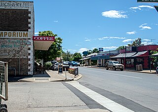
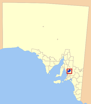
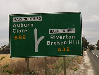
Riverton is a small town in the Mid North of South Australia, in the Gilbert Valley. It is situated on the Gilbert River, from which the town derives its name. Both the Gilbert Valley and Gilbert River were named after the South Australian pioneer Thomas Gilbert. Riverton was first settled in 1856, as a settlement along the bullock track from the mining town of Burra to the capital city Adelaide. It grew from a plan designed by a James Masters who had established the nearby town of Saddleworth. The streets of Riverton received their names chiefly from James Masters and his friends. They commemorate persons notable in the history of the district or the state. At the 2011 census, Riverton had a population of 810. Including the rural areas surrounding the town, the population was 1213.

The Barossa Light & Gawler Football Association, more commonly referred to as the BL&GFA, is an Australian rules football competition based in the Barossa Valley, Gawler Region and Light Region of South Australia, Australia. Just 42 kilometres north of the state capital of Adelaide, the BL&GFA is an affiliated member of the South Australian National Football League. In 2022, Nuriootpa secured the premiership cup for a record equalling eighth time. The current president of the League is Mick Brien and the major sponsor of the league is the Grant Burge Winery.

The Light River, commonly called the River Light, is a seasonal and significant river in the Mid North region of the Australian state of South Australia named for early surveyor William Light.

Barossa zone is a wine zone located in central South Australia west of the Murray River and which occupies the Barossa Valley, the Eden Valley and some adjoining land. The zone which is enclosed by the Mount Lofty Ranges zone on three sides and by the Lower Murray zone to its east, contains two wine regions which have received appellation as Australian Geographical Indications (AGI). These are the Barossa Valley and Eden Valley regions. The Barossa zone also includes a broader area around these two defined regions. The zone received AGI in 1996.

The Hundred of Belvidere is a cadastral unit of hundred located in the north Barossa Valley of South Australia in the County of Light.
The District Council of Light was a local government area in South Australia from 1977 to 1996, seated at Freeling.
The Hundred of Gilbert is a cadastral unit of hundred in the northern Mount Lofty Ranges including the town of Riverton. It is one of the nine hundreds of the County of Light. It was proclaimed in 1851 by Governor Henry Young and named after the Gilbert River, which flows from north to south through the hundred. The river, in turn, was named in honour of South Australian pioneer Thomas Gilbert.
The Local Government Areas (Re-arrangement) Acts 1929 and 1931 were acts of the Parliament of South Australia. The application of the acts, via recommendations of the commission of the same name, led to the statewide re-arrangement of local government areas, effected from 1932 to 1935.
The District Council of Light was a local government area in South Australia from 1867 to 1892.

The Hundred of Alma is a cadastral unit of hundred located on the northern Adelaide Plains of South Australia spanning the township of Alma and the Alma Plains. The hundred was proclaimed in 1856 in the County of Gawler and named by Governor Richard Graves MacDonnell for the River Alma on the Crimean Peninsula, the location of the Battle of the Alma, the first Allied victory in the Crimean War. The hundred is bounded on the north by the Wakefield River and on the south by the Light River

The Hundred of Mudla Wirra is a cadastral unit of hundred located on the northern Adelaide Plains of South Australia, first proclaimed in 1847. The hundred is bounded on the north by the Light River and on the south by the Gawler River.
The Hundred of Grace is a cadastral unit of hundred located on the northern Adelaide Plains of South Australia spanning the township of Mallala and the Grace Plains. The hundred was proclaimed in 1856 in the County of Gawler and named by Governor Richard Graves MacDonnell after Grace Montgomery Farrell, wife of James Farrell, Dean of Adelaide. The hundred spans a significant portion of the lower Light River, which flows from north east to south west through the area.
The Hundred of Julia Creek is a cadastral unit of hundred located in the Mid North of South Australia. It was named by Governor Henry Young in 1851 after a local tributary of the Light River, the watercourse having been earlier named for Julia Gawler, daughter of the former governor George Gawler.

The Hundred of Nuriootpa is a cadastral unit of hundred in the County of Light, South Australia split between in the eastern Adelaide Plains and western Barossa Valley. Named in 1847 for an indigenous term officially thought to mean "bartering place" and traditionally used as neutral ground for trading between various indigenous tribes, it is bounded on the south and east by the North Para River.
The District Council of Kapunda was a local government area in South Australia from 1866 to 1996. The Kapunda town corporation was formed a year earlier in 1865 and ultimately amalgamated into the district council.

The District Council of Belvidere was a local government area in South Australia. It was created to provide local government in the Hundred of Belvidere on 13 December 1866 and combined into the District Council of Kapunda on 12 May 1932.

