
The Barossa Valley is a valley in South Australia located 60 kilometres (37 mi) northeast of Adelaide city centre. The valley is formed by the North Para River. It is notable as a major wine-producing region and tourist destination.

Gawler is the oldest country town on the Australian mainland in the state of South Australia. It was named after the second Governor of the colony of South Australia, George Gawler. It is about 40–44 km (25–27 mi) north of the centre of the state capital, Adelaide, and is close to the major wine producing district of the Barossa Valley. Topographically, Gawler lies at the confluence of two tributaries of the Gawler River, the North and South Para rivers, where they emerge from a range of low hills.

Barossa Valley Way is the main road linking most of the major towns of the Barossa Valley in South Australia, designated as route B19 for its entire length. It is 35 km long, roughly following the North Para River.

The Town of Gawler is a local government area located north of Adelaide city centre in South Australia containing Gawler and its suburbs. The corporate town was established in 1857 due to the township's residents' dissatisfaction at being governed by three different district councils.

Nuriootpa ( NURE-ee-UUT-pə) is a town in South Australia and the major commercial centre of the Barossa Valley, about an hour's drive north of the state capital, Adelaide, and 77 kilometres by rail. The name of the town is reputed to be the local Aboriginal word for "meeting place".

The Mount Lofty Ranges are a range of mountains in the Australian state of South Australia which for a small part of its length borders the east of Adelaide. The part of the range in the vicinity of Adelaide is called the Adelaide Hills and defines the eastern border of the Adelaide Plains.

Main North Road is the major north-south arterial route through the suburbs north of the Adelaide City Centre in the city of Adelaide, South Australia. It continues north through the settled areas of South Australia and is a total of 307 kilometres (191 mi) long, from North Adelaide to 21 kilometres (13 mi) out of Port Augusta. It follows the route established in the early years of the colony by explorer John Horrocks and was a major route for farmers and graziers to reach the capital, passing through rich farmland and the Clare Valley wine region. In 2011, the section of road between Gawler to Wilmington was renamed Horrocks Highway.
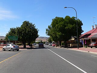
Lyndoch is a town in Barossa Valley, located on the Barossa Valley Highway between Gawler and Tanunda, 58 km northeast of Adelaide. The town has an elevation of 175m and an average rainfall of 560.5mm. It is one of the oldest towns in South Australia.

Williamstown is a small South Australian town on the southern fringe of the Barossa Valley wine-growing region. It is 51 km north east of Adelaide and 16 km south-east of Gawler. Williamstown was originally known as Victoria Creek. The township was laid out in 1858 by Lewis Johnston, or Johnstone, on land he purchased in 1857, and named for his son.

The South Para River is a river located in the Mount Lofty Ranges northeast of Adelaide in the Australian state of South Australia.

The Barossa Light & Gawler Football Association, more commonly referred to as the BL&GFA, is an Australian rules football competition based in the Barossa Valley, Gawler Region and Light Region of South Australia, Australia. Just 42 kilometres north of the state capital of Adelaide, the BL&GFA is an affiliated member of the South Australian National Football League. In 2021, South Gawler secured the premiership cup for their fourth BLGFA title. The current president of the League is Mick Brien and the major sponsor of the league is the Grant Burge Winery.

The County of Adelaide is one of the 49 cadastral counties of South Australia and contains the city of Adelaide. It was proclaimed on 2 June 1842 by Governor Grey. It is bounded by the Gawler River and North Para River in the north, the Mount Lofty Ranges in the east, and Gulf St Vincent in the west. The south border runs from Aldinga Bay to Willunga South and Mount Magnificent.
The Barossa Valley railway line is a railway line with several branches, running from Gawler into and through the Barossa Valley. The original terminus was at Angaston. A branch was built from Nuriootpa via Stockwell to Truro, and a further branch from that to Penrice. The Angaston and Truro branches are closed and removed; the line to Penrice remains but has not been used since 2014.

Barossa zone is a wine zone located in central South Australia west of the Murray River and which occupies the Barossa Valley, the Eden Valley and some adjoining land. The zone which is enclosed by the Mount Lofty Ranges zone on three sides and by the Lower Murray zone to its east, contains two wine regions which have received appellation as Australian Geographical Indications (AGI). These are the Barossa Valley and Eden Valley regions. The Barossa zone also includes a broader area around these two defined regions. The zone received AGI in 1996.
The Barossa Trail is a 40 kilometres (25 mi) cycling and walking path through the Barossa Valley in South Australia. Until 2019 the 27km between Gawler and Tanunda was named the Jack Bobridge Track.

The County of Light is one of the 49 cadastral counties of South Australia. It was proclaimed by Governor George Grey in 1842 and named for the River Light, the river being named after Colonel William Light, the first Surveyor-General of South Australia. It covers the modern region of the Barossa Valley and a portion of the northern Mt Lofty Ranges. It is bounded by the upper Wakefield River in the north, the approximate path of Horrocks Highway in the west, and the North Para River in the south, and is bisected east to west by the River Light.

The Hundred of Barossa is a cadastral unit of hundred in South Australia in the northern Adelaide Hills. It lies west of the Barossa Range at the south end of the Barossa Valley and is bounded on the north and south by the North Para and South Para rivers, respectively. It is the most northern of the eleven hundreds of the County of Adelaide and was named in 1846 by Governor Frederick Robe after the Barossa Range.
Concordia is a locality at the western end of the Barossa Valley, South Australia, situated 5 km ENE of Gawler.

The Hundred of Nuriootpa is a cadastral unit of hundred in the County of Light, South Australia split between in the eastern Adelaide Plains and western Barossa Valley. Named in 1847 for an indigenous term officially thought to mean "bartering place" and traditionally used as neutral ground for trading between various indigenous tribes, it is bounded on the south and east by the North Para River.

The Barossa District Football & Netball Club is an Australian sports club based in the Barossa Valley region of South Australia. The club is nicknamed the Bulldogs and represents the towns of Lyndoch and Williamstown. Sports practised at Barossa are Australian rules football and netball, with teams competing in the Barossa Light & Gawler Football Association

