
The Murray River is a river in south-eastern Australia. It is Australia's longest river at 2,508 km (1,558 mi) extent. Its tributaries include five of the next six longest rivers of Australia. Together with that of the Murray, the catchments of these rivers form the Murray–Darling basin, which covers about one-seventh the area of Australia. It is widely considered Australia's most important irrigated region.

The River Torrens, is the most significant river of the Adelaide Plains. It was one of the main reasons for the siting of the city of Adelaide, capital of South Australia. It flows 85 kilometres (53 mi) from its source in the Adelaide Hills near Mount Pleasant, across the Adelaide Plains, past the city centre and empties into Gulf St Vincent between Henley Beach South and West Beach. The upper stretches of the river and the reservoirs in its watershed supply a significant part of the city's water supply.

The South Australia Police (SAPOL) is the police force of the Australian state of South Australia. It is an agency of the Government of South Australia within the South Australian Department of Justice. SAPOL is directed by the Commissioner of Police, who reports to the Minister for Police. As of 30 June 2017, South Australia Police had 4948 active sworn members, including 339 cadets in training and 132 protective services officers, as well as approximately 920 civilian staff operating across 28 metropolitan and 110 regional police stations.

The Port River is part of a tidal estuary located north of the Adelaide city centre in the Australian state of South Australia. It has been used as a shipping channel since the beginning of European settlement of South Australia in 1836, when Colonel Light selected the site to use as a port. Before colonisation, the Port River region and the estuary area were known as Yerta Bulti by the Kaurna people, and used extensively as a source of food and plant materials to fashion artefacts used in daily life.
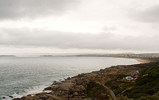
Encounter Bay is a bay in the Australian state of South Australia located on the state's south central coast about 100 kilometres (62 mi) south of the state capital of Adelaide. It was named by Matthew Flinders after his encounter on 8 April 1802 with Nicolas Baudin, the commander of the Baudin expedition of 1800–03. It is the site of both the mouth of the River Murray and the regional city of Victor Harbor. It is one of four "historic bays" located on the South Australian coast.

Murray Mouth is the point at which the River Murray meets the Southern Ocean. The Murray Mouth's location is changeable. Historical records show that the channel out to sea moves along the sand dunes over time. At times of greater river flow and rough seas, the two bodies of water would erode the sand dunes to create a new channel leaving the old one to silt and disappear.

Hallett Cove is a coastal suburb of Adelaide, South Australia located in the City of Marion 21 kilometres south of the Adelaide city centre. It has a population of more than 12,000 people. Adjoining suburbs are Marino to the north, Trott Park and Sheidow Park to the east and Lonsdale to the south.

The Onkaparinga River, known as Ngangkiparri or Ngangkiparingga in the Kaurna language, is a river located in the Southern Adelaide region in the Australian state of South Australia. Rising in the Mount Lofty Ranges, the river's estuary extends from Old Noarlunga to the river's mouth between the suburbs of Port Noarlunga and Port Noarlunga South.

Port Noarlunga is a suburb in the City of Onkaparinga, South Australia. It is a small sea-side suburb, population 2,918, about 30 kilometres to the south of the Adelaide city centre and was originally created as a sea port. This area is now popular as a holiday destination or for permanent residents wishing to commute to Adelaide or work locally. There is a jetty that connects to a 1.6 kilometres long natural reef that is exposed at low tide. The beach is large and very long and has reasonable surfing in the South Port area whose name is taken from its location - "South of the Port".

Eudunda is a rural town in South Australia, roughly 103 kilometres northeast of Adelaide, established in 1870 after settlers began moving into the area in the 1860s. As of the 2006 census, Eudunda had a population of 640.
Mount Crawford is a hill in the locality also named Mount Crawford in South Australia approximately 15 kilometres (9.3 mi) north of Birdwood in the Mount Lofty Ranges.

Inman Valley is a locality in the Australian state of South Australia located on the Fleurieu Peninsula about 86 kilometres (53 mi) south of the state capital of Adelaide. The valley is about 380 square kilometres (150 sq mi) in area. At the 2016 census, Inman Valley had a population of 343.
The Bungala River is a river located on the Fleurieu Peninsula in the Australian state of South Australia.

The Patawalonga River is a river located in the western suburbs of the Adelaide metropolitan area, in the Australian state of South Australia. It drains an area of flat, swampy lands formerly known as the Cowandilla Plains or The Reedbeds, which in the mid-20th century were drained by engineering works, enabling the establishment of Adelaide Airport and the development of residential housing.

Henry Inman (1816–1895) was an English cavalry officer, pioneer of South Australia, founder and first commander of the South Australia Police, overlander and Anglican clergyman.

Dry Creek or Dry Creek Drain is a seasonal stream in South Australia which passes through the Adelaide suburbs of Modbury, Walkley Heights and Pooraka. The nearby suburb of Dry Creek and Dry Creek railway station are named after the stream.

Nepean Bay is a bay located on the north-east coast of Kangaroo Island in the Australian state of South Australia about 130 kilometres south-south-west of Adelaide. It was named by the British navigator, Matthew Flinders, after Sir Evan Nepean on 21 March 1802.
The County of Hindmarsh is one of the 49 cadastral counties of South Australia. It was proclaimed by Governor George Grey in 1842 and named for Governor John Hindmarsh.
The Jarildekald (Yarilde) are an indigenous Australian people of South Australia originating on the eastern side of Lake Alexandrina and the Murray River.
The Ngarkat is a recorded title of a tribal group from South Australia. The Ngarkat lands had linked the mallee peoples of Victoria and South Australia to the river peoples of the Murray River Murraylands. Ngarkat language has been loosely grouped with Peramangk language though not by linguists, and the grouping was perhaps partly owed to the co-ownership of lands in both the Ninety Mile Desert and Echunga by John Barton Hack, and partly to the occasional meeting of tribes. The language of the Ngarkat was recorded as being Boraipur by Ryan in recent times though sources were not given, while it may yet be telling that the citing work concerns Mallee peoples to the east. The language may have been midway between that of mallee peoples to the east, and that of peoples to the west recorded by Teichelmann and Schurman. It is known that songlines linked the Coorong to the Mallee regions, hence went through Ngarkat land. It is also known that Ngarkat people did meet regularly with tribes to the east, at sites along the Murray.


