
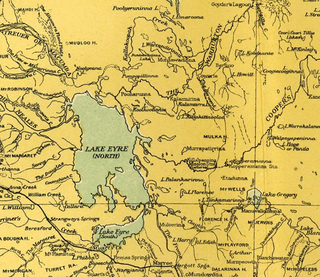
Lake Eyre, officially known as Kati Thanda–Lake Eyre, is an endorheic lake in east-central Far North South Australia, some 700 km (435 mi) north of Adelaide. The shallow lake is the depocentre of the vast endorheic Lake Eyre basin, and contains the lowest natural point in Australia at approximately 15 m (49 ft) below sea level (AHD), and on the rare occasions that it fills completely, is the largest lake in Australia covering an area up to 9,500 km2 (3,668 sq mi). When the lake is full, it has the same salinity level as seawater, but becomes hypersaline as the lake dries up and the water evaporates.
Kati Thanda-Lake Eyre National Park is a protected area in the Australian state of South Australia. It is located 697 km north of the state capital of Adelaide within the gazetted locality of Lake Eyre. It contains both the North and South sections of Lake Eyre as well as sections of the Tirari Desert.

The Lake Eyre basin is a drainage basin that covers just under one-sixth of all Australia. It is the largest endorheic basin in Australia and amongst the largest in the world, covering about 1,200,000 square kilometres (463,323 sq mi), including much of inland Queensland, large portions of South Australia and the Northern Territory, and a part of western New South Wales. The basin is also one of the largest, least-developed arid zone basins with a high degree of variability anywhere. It supports only about 60,000 people and has no major irrigation, diversions or flood-plain developments. Low density grazing that sustains a large amount of wildlife is the major land use, occupying 82% of the total land within the basin. The Lake Eyre basin of precipitation to a great extent geographically overlaps the Great Artesian Basin underneath.

The Cooper Creek is one of the most famous rivers in Australia because it was the site of the death of the explorers Burke and Wills in 1861. It is sometimes known as the Barcoo River from one of its tributaries and is one of three major Queensland river systems that flow into the Lake Eyre basin. The flow of the creek depends on monsoonal rains falling months earlier and many hundreds of kilometres away in eastern Queensland. It is 1,300 kilometres (810 mi) in length.
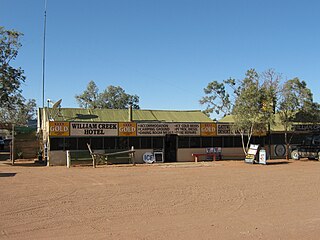
William Creek, Australia is located halfway on the Oodnadatta Track, 210 km (130 mi) north west of Marree and 166 km (103 mi) east of Coober Pedy in South Australia. The town has a permanent population of 10. William Creek is in the federal Division of Grey and the state electorate of Stuart. It is outside of council areas, and administered by the Outback Communities Authority.
Lake Torrens is a large ephemeral, normally endorheic salt lake in central South Australia. After sufficiently extreme rainfall events, the lake flows out through the Pirie-Torrens corridor to the Spencer Gulf.
The Eyre Peninsula is a triangular peninsula in South Australia. It is bounded by the Spencer Gulf on the east, by the Great Australian Bight on the west, and by the Gawler Ranges on the north.

Innamincka, formerly Hopetoun, is a township and locality in north-east South Australia with a population of 44 people as of the 2016 census. By air it is 820 kilometres north-east of the state capital, Adelaide, and 365 kilometres north-east of the closest town, Lyndhurst. It is 66 kilometres north-east of the Moomba Gas Refinery. The town lies within the Innamincka Regional Reserve and is surrounded by the Strzelecki Desert to the south and the Sturt Stony Desert to the north. It is linked by road to Lyndhurst via the Strzelecki Track, to the Birdsville Developmental Road via Cordillo Downs Road and Arrabury Road, and the Walkers Crossing Track to the Birdsville Track. The Walkers Crossing Track is closed in summer and only traversable in dry weather. The township is situated along the Cooper Creek, a part of the Lake Eyre basin.
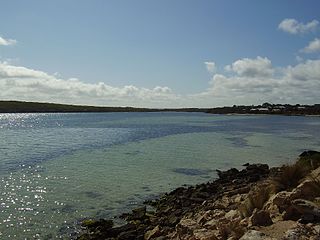
Coffin Bay, originally Coffin's Bay, is a town at the southern extremity of the Eyre Peninsula, a wheat growing area of South Australia. At the 2016 census, Coffin Bay had a population of 611.
Koonalda Cave is a cave in the Australian state of South Australia, on the Nullarbor Plain in the locality of Nullarbor. It is notable as an archeological site.

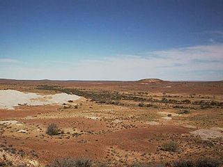
The Tirari Desert is a 15,250 square kilometres (5,888 sq mi) desert in the eastern part of the Far North region of South Australia. It stretches 212 km from north to south and 153 km from east to west.
The Lake Ngapakaldi to Lake Palankarinna Fossil Area is a group of fossil sites located in the Australian state of South Australia within the Tirari Desert in the north-eastern part of the state's Far North region. The group has an overall area of 35 square kilometres (14 sq mi) and is located about 70 kilometres (43 mi) east of Lake Eyre and about 100 kilometres (62 mi) north-north-east of Marree, off the Birdsville Track near Etadunna Station.

South Australia is an Australian state, situated in the southern central part of the country, and featuring some low-lying mountain ranges, the most significant being the Mount Lofty Ranges, which extend into the state's capital city, Adelaide, which comprises most of the state's population. Adelaide is situated on the eastern shores of Gulf St Vincent, on the Adelaide Plains, north of the Fleurieu Peninsula, between Gulf St Vincent and the low-lying Mount Lofty Ranges. The state of South Australia, which stretches along the coast of the continent and has boundaries with every other state in Australia, with the exception of the Australian Capital Territory and Tasmania. The Western Australia border has a history with South Australia, involving the South Australian Government Astronomer, Dodwell and the Western Australian Government Astronomer, Curlewis in the 1920s to mark the border on the ground.
Macumba River, once known as Treuer River, is an ephemeral freshwater stream in the far north of South Australia, that is part of the Lake Eyre Basin.
Sleaford Mere Conservation Park, formerly the Sleaford Mere National Park, is a protected area in the Australian state of South Australia located in the locality of Sleaford on the Jussieu Peninsula at the south eastern tip of Eyre Peninsula about 15 kilometres (9.3 mi) south west of Port Lincoln.
The Alberga River, also known as the Alberga Creek, is an ephemeral river that is part of the Lake Eyre basin located in the Far North region of the Australian state of South Australia.
The Frome River is an ephemeral river in the Australian state of South Australia located within the Lake Eyre basin. Its source is near Mount Rose in the northern Flinders Ranges and it discharges into the south-eastern side of the northern part of Lake Eyre.
The Strzelecki Creek, part of the Lake Eyre basin, is an ephemeral watercourse located in the Australian state of South Australia.
Etadunna is a locality in the Australian state of South Australia located about 684 kilometres north of the capital city of Adelaide and about 108 kilometres north-east of the town of Marree.
Allandale Station is a locality in the Australian state of South Australia located about 848 kilometres (527 mi) north of the state capital of Adelaide and about 20 kilometres (12 mi) south-east of the town of Oodnadatta.

