Rocky River (South Australia)

Last updated

Rocky
River
Country Australia
State South Australia
Region Mid North
Part of Broughton River
Tributaries
 - left Appila Creek, Pine Creek, Pisant/Yanga Creek,Narridy Creek, Yackamoorundie/Rocky Creek
 - right Ippinitchie
Source Frypan Hill
 - location Wirrabara Forest
 - elevation 700 m (2,297 ft)
Mouth confluence with the Broughton River
 - location southwest of Crystal Brook
 - coordinates 33°24′01″S138°07′59″E / 33.4002°S 138.1331°E / -33.4002; 138.1331 Coordinates: 33°24′01″S138°07′59″E / 33.4002°S 138.1331°E / -33.4002; 138.1331
Length 102 km (63 mi)
Basin 1,350 km2 (521 sq mi)
Australia South Australia relief location map.png
Red pog.svg
Location of the river mouth in South Australia
[1] [2]

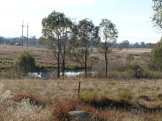
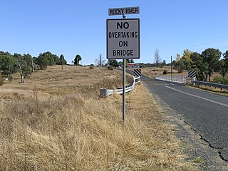
The Rocky River is a river located in the Mid North region of the Australian state of South Australia.

Mid North region of South Australia

The Mid North is a region of South Australia, north of the Adelaide Plains, but not as far north as the Far North, or the outback. It is generally accepted to extend from Spencer Gulf east to the Barrier Highway, including the coastal plain, the southern part of the Flinders Ranges, and the northern part of the Mount Lofty Ranges. The area was settled as early as 1840 and provided early farming and mining outputs for the fledgling colony. Farming is still significant in the area, particularly wheat, sheep and grapevines. There are not currently any significant mining activities in the Mid North.

South Australia State of Australia

South Australia is a state in the southern central part of Australia. It covers some of the most arid parts of the country. With a total land area of 983,482 square kilometres (379,725 sq mi), it is the fourth-largest of Australia's states and territories by area, and fifth largest by population. It has a total of 1.7 million people, and its population is the second most highly centralised in Australia, after Western Australia, with more than 77 percent of South Australians living in the capital, Adelaide, or its environs. Other population centres in the state are relatively small; Mount Gambier, the second largest centre, has a population of less than 30,000.

Contents

Course and features

The river rises near the Wirrabara Forest and, after initially flowing north, flows in a generally southern direction past the towns of Wirrabara, Stone Hut, Laura and Gladstone before reaching its confluence with the Broughton River. Tributaries include Ippinitchie, Pine, Appila, Pisant, Narridy and Yackamoorundie creeks. [2] The catchment area of Rocky River is approximately 1,350 square kilometres (520 sq mi). [2] The river descends 612 metres (2,008 ft) over its 102 kilometres (63 mi) course. [1]

Wirrabara, South Australia Town in South Australia

Wirrabara is a town and a locality in South Australia. Wirrabara is located in the Southern Flinders Ranges in the Mid North of South Australia, along the Rocky River. The Horrocks Highway passes through the town.

Laura, South Australia Town in South Australia

Laura is a rural town in the Mid North region of South Australia, 12 km north of Gladstone on the Horrocks Highway and 40 km east of Port Pirie. The first European to explore the district was Thomas Burr in September 1842. His promising reports soon led to occupation of the district by pastoralists, one of whom was Herbert Bristow Hughes. When the present town was surveyed he named it for his wife, Laura née White.

Gladstone, South Australia Town in South Australia

Gladstone is a small rural town in the Mid North of South Australia in the approach to the lower Flinders Ranges. At the 2006 census, Gladstone had a population of 629.

See also

Related Research Articles

Fitzroy River (Queensland) river in Queensland, Australia

The Fitzroy River is a river located in Central Queensland, Australia. Its catchment covers an area of 142,665 square kilometres (55,083 sq mi), making it the largest river catchment flowing to the eastern coast of Australia.

Severn River (New South Wales) river

The Severn River, a perennial river that forms part of the Border Rivers group, is part of the Macintyre catchment of the Murray-Darling basin, located in the Northern Tablelands and North West Slopes regions of New South Wales, Australia.

Wollondilly River river in Australia

The Wollondilly River, an Australian perennial river that is part of the Hawkesbury–Nepean catchment, is located in the Southern Tablelands and Southern Highlands regions of New South Wales. The river meanders from its western slopes near Crookwell, flowing south-east through Goulburn, turning north-east to near Bullio, flowing north-west to Barrallier, before finally heading north-easterly into its mouth at Lake Burragorang.

Crystal Brook (creek) river in South Australia, Australia

The Crystal Brook is an ephemeral stream located in the Mid North region of the Australian state of South Australia.

Berowra Creek river in New South Wales, Australia

The Berowra Creek, a watercourse that is part of the Hawkesbury-Nepean catchment, is located to the north of the Sydney central business district in the Hornsby Shire of New South Wales, Australia.

Rocky Creek Dam

Rocky Creek Dam is a minor rock fill clay core embankment dam across the Rocky Creek, located upstream of Lismore in the Northern Rivers region of New South Wales, Australia. The dam's main purpose is to supply potable water for the region, including Lismore, Ballina, Byron Bay, Evans Head and Alstonville. The impounded reservoir is called Rocky Lake.

Mole River (New South Wales) river in New South Wales, Australia

The Mole River, a watercourse that is one of the Border Rivers and part of the Macintyre catchment within the Murray–Darling basin, is located in the Northern Tablelands region of New South Wales, Australia.

Grose River river in Australia

The Grose River, a perennial river that is part of the Hawkesbury-Nepean catchment, is located in the Blue Mountains region of New South Wales, Australia.

Wilsons River (New South Wales) river in New South Wales, Australia

Wilsons River, a perennial river and part of the Richmond River catchment, is situated in the Northern Rivers district of New South Wales, Australia.

Warragamba River river in New South Wales, Australia

The Warragamba River, a river that is part of the Hawkesbury-Nepean catchment, is located in the Macarthur region of New South Wales, Australia.

Boorowa River river in Australia

Boorowa River, a perennial stream that is part of the Lachlan catchment within the Murray–Darling basin, is located in the central–western region of New South Wales, Australia.

Rocky River (New South Wales) river in Australia

Rocky River, a watercourse of the Gwydir catchment within the Murray–Darling basin, is located in the Northern Tablelands district of New South Wales, Australia.

Broughton River (South Australia) river in Australia

The Broughton River is a river in the Australian state of South Australia.

Billabong Creek river in Australia

The Billabong Creek, a partly perennial stream of the Murray River catchment within the Murray-Darling basin, is located in the Riverina region of New South Wales, Australia.

Mirrool Creek

The Mirrool Creek, a watercourse that is part of the Lachlan sub-catchment of the Murrumbidgee catchment within the Murray–Darling basin, is located in the Riverina region of New South Wales, Australia. The course of the Mirrool Creek is indefinite at various locations.

Rocky Ponds Creek

The Rocky Ponds Creek, a watercourse that is part of the Murrumbidgee catchment within the Murray–Darling basin, is located in the South West Slopes region of New South Wales, Australia.

Sandy Creek (Mirrool)

The Sandy Creek, a partly–perennial stream that is part of the Lachlan sub-catchment of the Murrumbidgee catchment within the Murray–Darling basin, is located in the Riverina region of New South Wales, Australia. The course of the Sandy Creek becomes indefinite at its mouth.

Rocky River (Kangaroo Island)

The Rocky River is a stream located within Flinders Chase National Park on Kangaroo Island in the Australian state of South Australia.

Wirrabara Range Conservation Park Protected area in South Australia

Wirrabara Range Conservation Park is a protected area located in the Australian state of South Australia in the locality of Wirrabara about 215 kilometres (134 mi) north of the state capital of Adelaide and about 11 kilometres (6.8 mi) west of the town of Wirrabara.

References

  1. 1 2 "Map of Rocky River, SA". Bonzle Digital Atlas of Australia. Retrieved 25 March 2017.
  2. 1 2 3 "Rocky River Catchment Water Resources Assessment" (PDF). WaterConnect. Government of South Australia . Retrieved 19 December 2015.