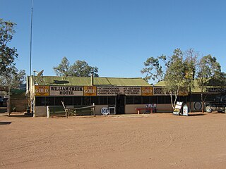
William Creek, Australia is located halfway on the Oodnadatta Track, 210 km (130 mi) north west of Marree and 166 km (103 mi) east of Coober Pedy in South Australia. The town has a permanent population of 10. William Creek is in the federal Division of Grey and the state electorate of Stuart. It is outside of council areas, and administered by the Outback Communities Authority.
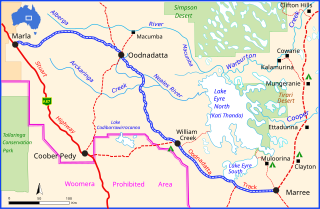
The Oodnadatta Track is an unsealed 614 km (382 mi) outback road in the Australian state of South Australia, connecting Marla in the north-west via Oodnadatta to Marree in the south-east. Along the way, the track passes the settlements of Oodnadatta and William Creek, the southern lake of the Kati Thanda-Lake Eyre National Park, and mound springs known as Freeling Springs, Strangways Springs, and The Bubbler and Blanche Cup.
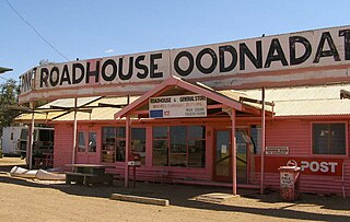
Oodnadatta is a small, remote outback town and locality in the Australian state of South Australia, located about 873 kilometres (542 mi) north of the state capital of Adelaide and 112 m above sea level.

The former Central Australia Railway, which was built between 1878 and 1929 and closed in 1980, was a 1,241 km (771 mi) 1067 mm narrow gauge railway between Port Augusta and Alice Springs. A standard gauge line duplicated the southern section from Port Augusta to Maree in 1957 on a new nearby alignment. The entire Central Australia Railway was superseded in 1980 after the standard gauge Tarcoola–Alice Springs Railway was opened, using a new route up to 200 km to the west. A small southern section of the original line between Port Augusta and Quorn has been preserved as the Pichi Richi Tourist Railway.

The Flinders Highway is a highway that crosses Queensland east to west, from Townsville on the Pacific coast to Cloncurry. The road continues as the Barkly Highway from Cloncurry to the Northern Territory border at Camooweal and beyond. The Flinders Highway passes a number of small outback towns and typical outback landscape predominates towards the inland. It was known as National Route 78 before Queensland began to convert to the alphanumeric system being adopted in Australia and is now designated as A6. The highway is also known as Overlanders Way. Its entire length is part of the National Land Transport Network.

The City of Port Augusta is a local government area located at the northern end of Spencer Gulf in South Australia. It is centred on the town of Port Augusta. The city was the site of South Australia's main power supplier, the Port Augusta powerhouse, located on the coast of the Spencer Gulf.

The Adelaide Plains is a plain in South Australia lying between the coast on the west and the Mount Lofty Ranges on the east. The southernmost tip of the plain is in the southern seaside suburbs of Adelaide around Brighton at the foot of the O'Halloran Hill escarpment with the south Hummocks Range and Wakefield River roughly approximating the northern boundary.

Beltana is a town 540 kilometres (336 mi) north of Adelaide, South Australia. Beltana is known for continuing to exist long after the reasons for its existence had ceased. The town's history began in the 1870s with the advent of copper mining in the area, construction of the Australian Overland Telegraph Line and The Ghan railway and began to decline in 1941 with the beginning of coal mining at Leigh Creek. The fortune of the town was sealed by the 1983 realignment of the main road away from the town. The town, adjacent cemetery and railway structures are now part of a designated State Heritage Area declared in 1987.

The Kaiserstuhl Conservation Park is a protected area located in the Australian state of South Australia in the suburb of Flaxman Valley about 80 kilometres (50 mi) north-east of the state capital of Adelaide and about 12 kilometres (7.5 mi) south-east of the town of Tanunda.
Coorabie is a town and locality in the Australian state of South Australia located about 675 kilometres (419 mi) north-west of the state capital of Adelaide. It is outside of district council boundaries, and therefore managed by the Outback Communities Authority. It is located in the west of South Australia, and includes the Wahgunyah Conservation Park. The Eyre Highway passes through the locality, although the Coorabie township is south of the highway.

The North–South Motorway is a partially complete motorway traversing the inner western suburbs of Adelaide from Waterloo Corner in the north to Bedford Park in the south. Progressively constructed in stages since 2010, once complete it will replace the adjacent South Road as Adelaide's main north–south roadway and form the central section of the North–South Corridor, being flanked north and south by the Northern Expressway and Southern Expressway, respectively.

Macumba Station, often just called Macumba, is a pastoral lease in South Australia currently operating as a cattle station.

Macumba River, once known as Treuer River, is an ephemeral freshwater stream in the far north of South Australia, that is part of the Lake Eyre Basin.
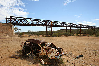
The Algebuckina Bridge is a Victorian era railway bridge in the Australian state of South Australia located about 55 kilometres (34 mi) south-east of the town of Oodnadatta in the locality of Allandale Station on the route of the now-closed Central Australia Railway. It opened in January 1892. It was the longest bridge in South Australia until construction of the Seaford suburban rail line across the Onkaparinga River south of Adelaide in 2014.

Todmorden Station, most commonly known as Todmorden, is a pastoral lease that operates as a cattle station in South Australia.

Telowie Gorge Conservation Park, formerly Telowie Gorge National Park, was a protected area located in the Australian state of South Australia to the east of the town of Port Germein in the gazetted locality of Telowie. It became part of the Wapma Thura–Southern Flinders Ranges National Park on 25 November 2021.

Wabma Kadarbu Mound Springs Conservation Park is a protected area in the Australian state of South Australia. It is located in Stuarts Creek, about 130 kilometres north of the town of Marree via the Oodnadatta Track in the state's Far North. The conservation park was proclaimed under the National Parks and Wildlife Act 1972 in 1996. As of 2012, it is subject to a co-management agreement between the Arabana aboriginal people and the Department for Environment and Water.
Nilpena Ediacara National Park, comprising the former Ediacara Conservation Park and an additional 60,000 ha, is a protected area located in the Australian state of South Australia about 30 kilometres south west of the town of Leigh Creek in the state's Far North, around 600 km (370 mi) north of the city of Adelaide. The national park was proclaimed in June 2021.

Katarapko is a locality in the Australian state of South Australia located in the Riverland about 188 kilometres north-east of the state capital of Adelaide and about 6.6 kilometres (4.1 mi) north of Loxton.
Allandale Station is a locality in the Australian state of South Australia located about 848 kilometres (527 mi) north of the state capital of Adelaide and about 20 kilometres (12 mi) south-east of the town of Oodnadatta.

