
Lake Alexandrina is a coastal freshwater lake located between the Fleurieu and Kangaroo Island and Murray and Mallee regions of South Australia, about 100 kilometres (62 mi) south-east of Adelaide. The lake adjoins the smaller Lake Albert and a coastal lagoon called The Coorong to its southeast, before draining into the Great Australian Bight via a short, narrow opening known as Murray Mouth.

Mount Barker is a city in South Australia. Located approximately 33 kilometres from the Adelaide city centre, it is home to 16,629 residents. It is the seat of the District Council of Mount Barker, the largest town in the Adelaide Hills, and one of the fastest-growing areas in the state.

Alexandrina Council is a local government area in the Fleurieu and Kangaroo Island region of South Australia. The Alexandrina Council was formed on 1 July 1997 by the amalgamation of the District Council of Port Elliot and Goolwa, the District Council of Strathalbyn and a portion of the District Council of Willunga. The council is divided into five wards: Nangkita Kuitpo, Angas Bremer, Port Elliot Middleton, Strathalbyn and Goolwa Hindmarsh Island.

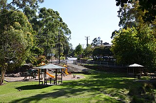
Macclesfield is a small town on the upper reaches of the River Angas in the Adelaide Hills region of South Australia. In the 2016 census, Macclesfield had a population of 832 while the 2016 Census showed an increase to 958.
Langhorne Creek is a town in South Australia. At the 2016 census, Langhorne Creek had a population of 427.
Currency Creek is a township and locality in South Australia on the western shore of Lake Alexandrina about 6 km north of Goolwa, beside a seasonal stream bearing the same name - Currency Creek - which flows into Lake Alexandrina. The locality includes the headland named Finniss Point which separates the mouths of Currency Creek and the Finniss River.
Bridgewater is a town in the Australian state of South Australia located in the Adelaide Hills to the south-east of the Adelaide city centre.
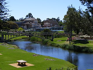
Strathalbyn is a town in South Australia, in the Alexandrina Council. As of 2016, the town had a population of approximately 6,500.

The Bremer River, part of the lower Murray-Darling catchment, is a river that is located in the Adelaide Hills region in the Australian state of South Australia.

Robert Cock was one of the first European explorers of the Adelaide region of South Australia following the establishment of the colony in December 1836.
Strathalbyn Road is a South Australian road connecting the towns of Aldgate, Mylor, Echunga, Macclesfield and Strathalbyn, designated part of route B33.
Donald McLean was a pastoralist in the early days of the British colony of South Australia, remembered as the colony's first wheat grower.

The Southern Argus is a newspaper first published from March 1866 in Port Elliot, South Australia, and then in Strathalbyn from 1868 to the present. It is published on Thursdays.

Edward Stirling was an early settler of South Australia. He established several pastoral properties and was a co-founder of what became Elders Limited, also serving two terms in the South Australian Legislative Council.

Langhorne Creek wine region is a wine region in South Australia that is located on the plains southeast of the town of Strathalbyn along the lower reaches of the Bremer River and Angas River to Lake Alexandrina. The region received appellation as an Australian Geographical Indication (AGI) in 1998 and as of 2014, has a total planted area of 5,883 ha and is represented by at least 24 wineries.
Belvidere is a small town in the Alexandrina Council area of South Australia. With the advent of improved transport, the town no longer has a school or post office. The Soldier's Memorial Hall was built in 1921 to commemorate the 17 young men of the district who served in World War I, five of whom did not return. It remains a part of the town and available for hire. It is located on the main road between Strathalbyn and Langhorne Creek near where the road to Milang branches off.
The Milang railway line was a branch line, now closed, of the former South Australian Railways that left the mainline to Victor Harbor at the farming locality of Sandergrove, 9 km (6 mi) south of Strathalbyn and 89.7 km (55.75 mi) by rail from Adelaide. From there it proceeded in a south-easterly direction for 13.1 km (8.1 mi) to the riverport of Milang on Lake Alexandrina, in the estuary of the River Murray. The line was opened on 17 December 1884; it was formally closed on 17 June 1970. The route is now a "rail trail" that is popular with hikers. The precincts of the former Milang station house a railway museum that includes an innovative locomotive driving simulator for visitors to operate. Onsite is a centre for South Australian historical light railways.

The County of Hindmarsh is one of the 49 cadastral counties of South Australia. It was proclaimed by Governor George Grey in 1842 and named for Governor John Hindmarsh.
Tolderol is a locality in the Australian state of South Australia located about 67 kilometres south of the Adelaide city centre, 32 kilometres north-east of the centre of Goolwa and 32 kilometres south-west of the centre of Murray Bridge on the west coastline of Lake Alexandrina.

The Hundred of Strathalbyn is a cadastral division of the County of Hindmarsh in South Australia. It lies west of the Adelaide Hills and east of Lake Alexandrina and includes at its southwestern extremity the town of Strathalbyn. Its name is derived from that used for a sub-division granted in 1841. No definitive derivation for the subdivision of Strathalbyn name is known but it is deemed probable that John Rankine or his brother William provided the name with the meaning given as "white valley" from the Scottish srath and albion. Mount Barker Creek forms much of the northern hundred boundary while the Bremer River forms the eastern border.

