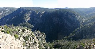
Glenelg River (Victoria)

Last updated

Glenelg
Glenelg River.jpg
Family canoeing on the Glenelg River
Glenelg River, Vic, Australia Map.png
Map of Glenelg River catchment
EtymologyIn honour of the Colonial Secretary, Baron Glenelg, Charles Grant [1]
Native name
Location
Country Australia
States Victoria, South Australia
Region Victorian Midlands, Naracoorte Coastal Plain (IBRA), Western Victoria, Limestone Coast, South Australia
Local government areas Southern Grampians (V), West Wimmera (V), Glenelg (V), Grant (SA)
Settlements Balmoral (V), Harrow (V), Casterton (V), Dartmoor (V), Donovans (SA), Nelson (V)
Physical characteristics
Source Grampian Ranges
  location Grampians National Park, Victoria
  coordinates 37°20′57″S142°15′57″E / 37.34917°S 142.26583°E / -37.34917; 142.26583
  elevation759 m (2,490 ft)
Mouth Discovery Bay, Great Australian Bight
  location
Nelson, Victoria
  coordinates
38°03′39″S140°59′8″E / 38.06083°S 140.98556°E / -38.06083; 140.98556
  elevation
0 m (0 ft)
Length350 km (220 mi) [10]
Basin size12,660 km2 (4,890 sq mi)
Discharge 
  location mouth
  average35 m3/s (1,200 cu ft/s)
Basin features
River system Glenelg Hopkins catchment
Tributaries 
  left Chetwynd River, Wannon River, Stokes River (Victoria), Crawford River (Victoria)
National parks Grampians, Lower Glenelg
[11]

The Glenelg River, a perennial river of the Glenelg Hopkins catchment, is located in the Australian states of Victoria and South Australia.

Contents

The river rises in the Grampian Ranges and flows generally north, then west, then south, for over 350 kilometres (220 mi), [10] making the river the longest river in south-west Victoria and third longest overall. A short stretch of the lower end winds through southeastern South Australia before returning to Victoria to enter Discovery Bay at Nelson. The Glenelg River is a central feature of the Lower Glenelg National Park.

The river was named after Colonial Secretary Baron Glenelg, Charles Grant, by Major Thomas Mitchell in August 1836. [1] [12]

Large amounts of water diverted from the upper reaches of the river for agricultural purposes, including irrigation and town water demands. The estuary is listed under the Heritage Rivers Act, 1992 (VIC) and is a nationally important wetland.

History

Aboriginal history

The Glenelg was important to Indigenous Australians. It formed the traditional tribal boundaries for the Bungandidj people (western bank) and Gunditjmara people (eastern bank) people from two distinct language groups. Little archeological evidence has been found of Bunganditj inhabitation along the banks of the river, including in regional caves. However, there is strong evidence of their presence further towards the coastal areas. [13] While strong evidence of Gunditjmara activity has been found along the river's eastern hinterland [14] and shell middens discovered may indicate multiple nomadic tribes camping along the river that may have used message sticks to communicate. [15] It is not known how long indigenous Australians had been associated with the river, however it is estimated to have been many thousands of years.

European history

Major Thomas Mitchell was the first European to visit and cross the river in August 1836, noting its width and its suitability for boating, naming it for Colonial Secretary Baron Glenelg, Charles Grant. [16] A cenotaph at Nelson marks the crossing point. The first Europeans arrived in 1840. Thomas Ricketts moved from the Barwon River to the Glenelg and established "Clunie" on its southern boundary. [17] Historians noted the hostility of the Indigenous people of the area who drove Ricketts out of the settlement and conflicted with many others. Addison and Murray from Van Diemen's Land set up the sheep run Dunrobin in January, 1840 after which more than half a dozen squatters others followed, and by the end of the year, many properties had river frontages and the population grew gradually thereafter.

A punt built in 1848 by Henry Kellett at Nelson was the first permanent crossing of the river. In 1860 a body of Mr Hunt and his wife were discovered under a bridge at Casterton, after which Mr Waines was subsequently tried and hanged for the murder. [17] On 1 July 1861, at Chetwynd station, a large tornado occurred reportedly killing a man. [17] [18] In 1866, one of the earliest artists depictions of the river by engraver Frederick Grosse "View of the River Glenelg, South Australia" was published depicting boating among its steep limestone cliffs. [19] The earliest crossings over the Glenelg were at Casterton. The first crossing over the wider reaches of the lower Glenelg was constructed out of wood in 1893 in Nelson. It was replaced by the current steel cantilever bridge in 1963.

Location and features

The Glenelg River rises at an elevation of 760 metres (2,490 ft) above sea level below The Chimney Pots within the Grampians National Park, on the eastern slopes of the Victoria Range, and west of the Serra Range, within the Grampian Range. The river flows north through swampland before heading west, transversed by the Henty Highway, and then south where the river is impounded by the Rocklands Reservoir, formed by a concretewalled gravity dam with embankment sections constructed in 1953. The reservoir has a maximum capacity of 348,300 megalitres (7.66×10¹⁰ imp gal; 9.20×10¹⁰ US gal). [20] [21] Leaving the dam wall, the river flows west through state forestry areas towards Balmoral, where the river is joined by the Salt, Mather, Yarramyljup, and Schofield Creeks, flowing to the east, north, then west of Balmoral, through the settlement of Harrow, where the river is met by another creek, also called Salt Creek. The Chetwynd River, draining the region north of Casterton and Coleraine, joins the Glenelg east of Burke Bridge. The Glenelg flows generally southwest, to the west of Dergholm State Park towards Dergholm, joined by a number of minor tributaries. From here the river flows south by east, through the town of Casterton, and south of which the 220-kilometre (140 mi) Wannon River forms its confluence with the Glenelg. Flowing south by west, the Glenelg flows through the Wilkin Flora and Fauna Reserve before heading due south, met by the Stokes River prior to flowing through the town of Dartmoor where the Crawford River forms its confluence with the Glenelg. Flowing south, then sharply west and crossing the state border into South Australia, the Glenelg flows through Donovans before heading east back into Victoria. The river reaches its mouth at Nelson and much of the latter course is through the Lower Glenelg National Park. From its highest point, the Glenelg River descends 760 metres (2,490 ft), joined by thirtytwo named tributaries over its 350-kilometre (220 mi) course. [10] [11]

Communities and significant crossings along the river

There are many crossings over the Glenelg River, including road, rail and pedestrian. Some additional roads allow passage through shallow sections of the river when the water levels are low.

Location Bridge name Comments/use Image
KanagulkNatimuk Hamilton Road
Harrow Coleraine-Edenhope Road
ConnewirricooKandnock-Connewirricoo Road
KadnookCasterton-Edenhope Road
DergholmDergholm-Chetwynd Road
WarrockWarrock Road
DunrobinSection Road
Casterton Glenelg Highway Casterton Glenelg Highway Bridge 001.JPG
Anderson Street
Sandford Sandford-Ballgalah Road
BahgallahCasterton-Dartmoor Road
StrathdownieMyaring-Pieracle Road
Dartmoor Greenham Street
Railway crossing
Princes Highway
Nelson Portland-Nelson Road; 1893 wooden; 1963 steel cantilever

Glenelg River Canoe Trail

The Glenelg River Canoe Trail can be found through the lower reaches of the river. Starting in Dartmoor, there is a stretch of flat water approximately 75 kilometres long, eventually ending in Nelson. [22]

Flora and fauna

The Glenelg River mussel, once plentiful but now critically endangered, [23] lives in small populations along the river. Work is being done to improve its habitat, after it was further threatened by the bushfires in 2019-2020. [24]

Populations of a local fish known as the tupong ( Pseudaphritis urvillii ) started to recover in the 2010s, after the health of the river had been significantly improved after more than a century of environmental degradation caused by the introduction of agriculture. Two Australian grayling were observed in early 2021, the first recorded sighting since 1899, and scientists are hopeful that they will make a similar comeback. [25]

See also

Related Research Articles

<span class="mw-page-title-main">Shire of Glenelg</span> Local government area in Victoria, Australia

The Shire of Glenelg is a local government area in the Barwon South West region of Victoria, Australia, located in the south-western part of the state. It covers an area of 6,219 square kilometres (2,401 sq mi) and in June 2018 had a population of 19,665. It includes the towns of Casterton, Heywood, Merino and Portland. Although a shire of the same name existed before the amalgamations of the mid-1990s, the current Shire was formed in 1994 from the amalgamation of the former Shire of Glenelg with the Shire of Heywood and City of Portland.

<span class="mw-page-title-main">Avon River (Gippsland, Victoria)</span> River in the Gippsland region of Victoria, Australia

The Avon River is a perennial river of the West Gippsland catchment, located in the West Gippsland region, of the Australian state of Victoria. The Avon, forms an important part of the Latrobe sub-catchment, draining the south eastern slopes of the Great Dividing Range, to form the Gippsland Lakes.

<span class="mw-page-title-main">Nelson, Victoria</span> Town in Victoria, Australia

Nelson is a small fishing town in Victoria, Australia. It is located at the mouth of the Glenelg River and Discovery Bay, a few kilometres from the South Australian border, and 422 kilometres (262 mi) west of Melbourne. At the 2016 census, Nelson and the surrounding area had a population of 190.

<span class="mw-page-title-main">Casterton, Victoria</span> Town in Victoria, Australia

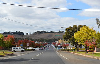
Casterton is a town in Victoria, Australia, located on the Glenelg Highway, 42 kilometres east of the South Australian border, in the Shire of Glenelg. The Glenelg River passes through the town. Casterton is named after the village of Casterton in south-east Cumbria in England.

<span class="mw-page-title-main">Discovery Bay (Australia)</span> An open oceanic embayment in Eastern South Australia and western Victoria

Discovery Bay is an open oceanic embayment lying along the coast of eastern South Australia and western Victoria in south-eastern Australia.

<span class="mw-page-title-main">Latrobe River</span> River in Victoria, Australia

The Latrobe River is a perennial river of the West Gippsland catchment, located in the West Gippsland region of the Australian state of Victoria. The Latrobe River and its associated sub-catchment is an important source for the Gippsland Lakes, draining the south eastern slopes of the Great Dividing Range.

<span class="mw-page-title-main">Tambo River (Victoria)</span> River in Victoria, Australia

The Tambo River or Berrawan is a perennial river of the Mitchell River catchment, located in the East Gippsland region of the Australian state of Victoria. With a total length in excess of 186 kilometres (116 mi), the Tambo River is one of the longest rivers in the East Gippsland drainage basin, extending from the steep forested southern slopes of the Victorian Alps through forest and farmland to the Gippsland Lakes.

<span class="mw-page-title-main">Wimmera River</span> River in Victoria, Australia

The Wimmera River, an inland intermittent river of the Wimmera catchment, is located in the Grampians and Wimmera regions of the Australian state of Victoria. Rising in the Pyrenees, on the northern slopes of the Great Dividing Range, the Wimmera River flows generally north by west and drains into Lake Hindmarsh and Lake Albacutya, a series of ephemeral lakes that, whilst they do not directly empty into a defined watercourse, form part of the Murray River catchment of the Murray-Darling basin.

<span class="mw-page-title-main">Woady Yaloak River</span> Perennial river in Victoria, Australia

The Woady Yaloak River is a perennial river of the Corangamite catchment, located in the Western District Lakes region of the Australian state of Victoria.

<span class="mw-page-title-main">Wannon River</span> River in Victoria, Australia

The Wannon River, a perennial river of the Glenelg Hopkins catchment, is located in the Western District of Victoria, Australia.

<span class="mw-page-title-main">Nicholson River (Victoria)</span> River in Victoria, Australia

The Nicholson River is a perennial river of the Mitchell River catchment, located in the East Gippsland region of the Australian state of Victoria.

The Watts River is a perennial river of the Port Phillip and Western Port catchment, located in the Healesville area, in the Central region of the Australian state of Victoria.

The Tarwin River is a perennial river of the West Gippsland catchment, located in the South Gippsland region of the Australian state of Victoria. The Tarwin River is the primary river system within South Gippsland Shire and has a catchment area of approximately 1,500 square kilometres (580 sq mi), predominantly rural with small pockets of residential land use. It flows south from the Strzlecki Ranges and discharges in the eastern reaches of Anderson Inlet, a shallow estuary connected to Bass Strait.

<span class="mw-page-title-main">Little River (Snowy River National Park)</span> River in Victoria, Australia

The Little River is a perennial river of the Snowy River catchment, located in the Alpine region of the Australian state of Victoria. It is one of two rivers of the same name that are tributaries of the Snowy River, the other being the Little River.

The Rodger River is a perennial river of the Snowy River catchment, located in the Alpine region of the Australian state of Victoria.

The Murrindal River is a perennial river of the Snowy River catchment, located in the East Gippsland region of the Australian state of Victoria.

The Wongungarra River is a perennial river of the Mitchell River catchment, located in the Alpine region of the Australian state of Victoria.

The Tyers River is a perennial river of the West Gippsland catchment, located in the West Gippsland region of the Australian state of Victoria.

The Chetwynd River, a perennial river of the Glenelg Hopkins catchment, is located in the Western District of Victoria, Australia.

The Mackenzie River, an inland intermittent river of the Wimmera catchment, is located in the Grampians region of the Australian state of Victoria. Rising in the Grampians National Park, on the northern slopes of the Great Dividing Range, the Mackenzie River flows generally north by west and drains into the Wimmera River, southwest of Horsham.

References

  1. 1 2 Mitchell, Thomas (1838), Three Expeditions into the interior of Eastern Australia (e-book), vol. 2, London: Boone
  2. "Lower Glenelg National Park, Discovery Bay Coastal Park: Visitor Guide" (PDF). Parks Victoria (PDF). Government of Victoria. June 2014. Archived from the original (PDF) on 21 February 2014. Retrieved 20 August 2014.|paren1=omit
  3. "Glenelg River: 3050: Traditional Name: Worrewurnin". Vicnames. Victoria State Government. 12 August 2011. Archived from the original on 14 January 2014. Retrieved 13 January 2014.
  4. "Glenelg River: 3050: Traditional Name: Bugara". Vicnames. Victoria State Government. 12 August 2011. Archived from the original on 14 January 2014. Retrieved 13 January 2014.
  5. "Glenelg River: 3050: Traditional Name: Temiangandgeen". Vicnames. Victoria State Government. 12 August 2011. Archived from the original on 14 January 2014. Retrieved 13 January 2014.
  6. "Glenelg River: 3050: Traditional Name: Wurri-wurri". Vicnames. Victoria State Government. 10 May 2011. Archived from the original on 14 January 2014. Retrieved 13 January 2014.
  7. "Glenelg River: 3050: Traditional Name: Barrawy". Vicnames. Victoria State Government. 12 August 2011. Archived from the original on 14 January 2014. Retrieved 13 January 2014.
  8. "Glenelg River: 3050: Traditional Name: Barker". Vicnames. Victoria State Government. 4 May 2011. Archived from the original on 14 January 2014. Retrieved 13 January 2014.
  9. "Glenelg River: 3050: Traditional Name: Wurru-wurru". Vicnames. Victoria State Government. 12 August 2011. Archived from the original on 14 January 2014. Retrieved 13 January 2014.
  10. 1 2 3 "Estuary facts and figures: Glenelg". Coast & Marine: Estuaries. Glenelg Hopkins Catchment Management Authority. Retrieved 4 June 2014.
  11. 1 2 "Map of Glenelg River". Bonzle Digital Atlas of Australia. Retrieved 4 June 2014.
  12. Bird, Eric (12 October 2006). "Place Names on the Coast of Victoria" (PDF). The Australian National Placename Survey (ANPS). Archived from the original (PDF) on 18 February 2011. Retrieved 23 July 2008.
  13. Lower Glenelg National Park Management Plan (PDF) (PDF). Victoria State Government. May 1991. p. 17. ISBN   0-7306-2068-9. Archived from the original (PDF) on 3 November 2013. Retrieved 4 June 2014.{{cite book}}: |work= ignored (help)
  14. "Archived copy" (PDF). Archived from the original (PDF) on 23 April 2011. Retrieved 13 April 2013.{{cite web}}: CS1 maint: archived copy as title (link)
  15. "Keicha Day". 5 April 2005.
  16. "Major Thomas Mitchell, August 1836, Glenelg River, Dartmoor, South-West Victoria, Australia".
  17. 1 2 3 "Gleneg River in History". The Argus. 19 April 1924. p. 8.
  18. "THE TORNADO AT CHETWYND STATION ON 1 JULY 1861". Bell's Life in Sydney and Sporting Chronicle. 15 February 1862.
  19. Grosse, Frederick (1866). "VIEW ON THE RIVER GLENELG SOUTH AUSTRALIA". Ebenezer and David Syme. Retrieved 5 June 2014.
  20. "Rocklands Reservoir". GWMWater. 4 June 2014. Archived from the original on 6 March 2014. Retrieved 4 June 2014.
  21. "Register of Large Dams in Australia" (Excel (requires download)). Dams information. Australian National Committee on Large Dams. 2010. Retrieved 4 June 2014.
  22. "Glenelg River Canoe Trail". parks.vic.gov.au. Retrieved 9 December 2021.
  23. Jones, Hugh A.; Klunzinger, M. (13 April 2014). "The IUCN Red List of Threatened Species". IUCN Red List of Threatened Species. Retrieved 30 October 2020.
  24. Whiteside, Grace (29 October 2020). "Funding to protect critically endangered Glenelg River mussels". Australia: ABC News. Retrieved 30 October 2020.
  25. Johnson, Sian (24 February 2021). "Australian grayling found in Glenelg River after 'vanishing' a century ago". Australia: ABC News. Retrieved 28 February 2021.