The Lower Glenelg National Park is a national park in the Western District of Victoria, Australia. The 27,300-hectare (67,000-acre) national park is situated approximately 323 kilometres (201 mi) west of Melbourne. The major features of the park are the Glenelg River gorge and the Princess Margaret Rose Cave. Much of the route of the Great South West Walk is located within the national park.

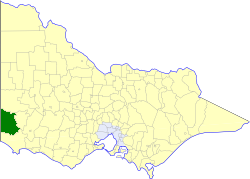
The Shire of Glenelg is a local government area in the Barwon South West region of Victoria, Australia, located in the south-western part of the state. It covers an area of 6,219 square kilometres (2,401 sq mi) and in June 2018 had a population of 19,665. It includes the towns of Casterton, Heywood, Merino and Portland. Although a shire of the same name existed before the amalgamations of the mid-1990s, the current Shire was formed in 1994 from the amalgamation of the former Shire of Glenelg with the Shire of Heywood and City of Portland.

The Moyne River, a perennial river of the Glenelg Hopkins catchment, is located in the Western District of Victoria, Australia.

The Hopkins River, a perennial river of the Glenelg Hopkins catchment, is located in the Western District of Victoria, Australia.

The Glenelg River, a perennial river of the Glenelg Hopkins catchment, is located in the Australian states of Victoria and South Australia.
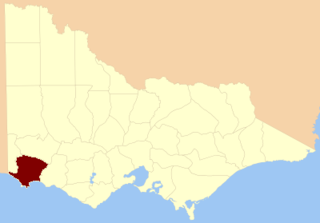
The Shire of Glenelg was a local government area about 360 kilometres (224 mi) west of Melbourne, the state capital of Victoria, Australia. The shire covered an area of 3,576 square kilometres (1,380.7 sq mi), and existed from 1863 until 1994.

The Wannon River, a perennial river of the Glenelg Hopkins catchment, is located in the Western District of Victoria, Australia.

The County of Dundas is one of the 37 counties of Victoria which are part of the cadastral divisions of Australia, used for land titles. The county is in the Western District of Victoria bounded by the Glenelg River in the west and north, by a line from Casterton to Penshurst in the south, and by the eastern edge of the Grampians in the east. Larger towns include Hamilton, Casterton and Coleraine. The county was proclaimed in 1849.
The County of Normanby in Victoria, is one of the 37 counties of Victoria which are part of the cadastral divisions of Australia, used for land titles. The county is in the Western District of Victoria bounded by the Glenelg River in the west and the Eumeralla River in the east, by a line through Casterton and Hamilton in the north, and by Bass Strait to the south. Larger towns include Hamilton, Portland and Heywood. The county was proclaimed in 1853, but it was known earlier since the 1849 proclamation of Follett County and Dundas County referred to its boundaries.
The Fitzroy River, a perennial river of the Glenelg Hopkins catchment, is located in the Western District of Victoria, Australia.
The Electoral district of Normanby was an electoral district in the Legislative Assembly of Victoria, it covered an area from the South Australian border to Portland Bay.
The Merri River, a perennial river of the Glenelg Hopkins catchment, is located in the Western District of Victoria, Australia.
The Shaw River, a perennial river of the Glenelg Hopkins catchment, is located in the Western District of Victoria, Australia.
The Surry River, sometimes incorrectly spelled as the Surrey River, a perennial river of the Glenelg Hopkins catchment, is located in the Western District of Victoria, Australia.
This article is intended as a catalogue of sleeping carriages used by the Victorian Railways and successors.
The Crawford River or Smoky River, a perennial river of the Glenelg Hopkins catchment, is located in the Western District of Victoria, Australia.
The Dundas River, a perennial river of the Glenelg Hopkins catchment, is located in the Western District of Victoria, Australia.
The Chetwynd River, a perennial river of the Glenelg Hopkins catchment, is located in the Western District of Victoria, Australia.
The Stokes River, a perennial river of the Glenelg Hopkins catchment, is located in the Western District of Victoria, Australia.
