The Old River

Last updated

The Old
River [1]
Country Australia
State Victoria
Regions Victorian Midlands (IBRA), Western District
Local government area Moorabool
Part of Port Phillip catchment
Source Mount Bullengarook, Blackwood Ranges, Great Dividing Range
 - location Lerderderg State Park
 - elevation 575 m (1,886 ft)
 - coordinates 37°31′06″S144°25′51″E / 37.51833°S 144.43083°E / -37.51833; 144.43083
Mouth confluence with the Lerderderg River
 - location below Mount Blackwood
 - elevation 271 m (889 ft)
 - coordinates 37°33′34″S144°23′49″E / 37.55944°S 144.39694°E / -37.55944; 144.39694 Coordinates: 37°33′34″S144°23′49″E / 37.55944°S 144.39694°E / -37.55944; 144.39694
Length 7 km (4 mi)
National park Lerderderg State Park
Australia Victoria relief location map.jpg
Red pog.svg
Location of The Old River mouth in Victoria
[1] [2]

The Old River is a perennial river of the Port Phillip catchment, located in the Western District region of the Australian state of Victoria.

A perennial stream or perennial river is a stream or river (channel) that has continuous flow in parts of its stream bed all year round during years of normal rainfall. "Perennial" streams are contrasted with "intermittent" streams which normally cease flowing for weeks or months each year, and with "ephemeral" channels that flow only for hours or days following rainfall. During unusually dry years, a normally perennial stream may cease flowing, becoming intermittent for days, weeks, or months depending on severity of the drought. The boundaries between perennial, intermittent, and ephemeral channels are not defined, and subject to a variety of identification methods adopted by local governments, academics, and others with a need to classify stream-flow permanence.

Port Phillip bay in Victoria, Australia

Port Phillip , is a port in southern Victoria, Australia. It is nearly surrounded by the city of Melbourne and its suburbs. Geographically, the port covers 1,930 square kilometres and the shore stretches roughly 264 km (164 mi). Although it is extremely shallow for its size, most of the port is navigable. The deepest portion is only 24 metres (79 ft), and half the region is shallower than 8 m (26 ft). The volume of the water in the port is around 25 cubic kilometres (6.0 cu mi).

Western District (Victoria) Region in Victoria, Australia

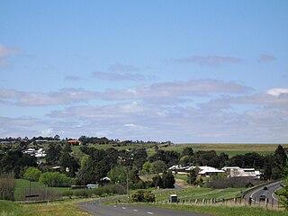
The Western District comprises western regions of the Australian state of Victoria. It is said to be an ill–defined district, sometimes incorrectly referred to as an economic region,. The district is located within parts of the Barwon South West and the Grampians regions; extending from the south-west corner of the state to Ballarat in the east and as far north as Ararat. The district is bounded by the Wimmera district in the north, by the Goldfields district in the east, by Bass Strait and the Southern Ocean in the south, and by the South Australian border in the west. The district is well known for the production of wool. The most populated city in the Western District is the Ballarat region, with 96,940 inhabitants.

Contents

Location and features

The Old River rises below Mount Bullengarook, part of the Blackwood Ranges of the Great Dividing Range, in remote country within the Lerderderg State Park. The river flows generally south by west before reaching its confluence with the Lerderderg River below Mount Blackwood. The river descends approximately 304 metres (997 ft) over its 7-kilometre (4.3 mi) course. [2]

Great Dividing Range mountain range in the Australian states of Queensland, New South Wales and Victoria

The Great Dividing Range, or the Eastern Highlands, is Australia's most substantial mountain range and the third longest land-based range in the world. It stretches more than 3,500 kilometres (2,175 mi) from Dauan Island off the northeastern tip of Queensland, running the entire length of the eastern coastline through New South Wales, then into Victoria and turning west, before finally fading into the central plain at the Grampians in western Victoria. The width of the range varies from about 160 km (100 mi) to over 300 km (190 mi). The Greater Blue Mountains Area, Gondwana Rainforests, and Wet Tropics of Queensland World Heritage Areas are located in the range.

Lerderderg State Park Protected area in Victoria, Australia

Lerderderg State Park is a 14,250-hectare park located between Bacchus Marsh and Blackwood, an hour's drive from Melbourne, Australia. There are several maintained tracks for walking through the park and camping is allowed.

Confluence Meeting of two or more bodies of flowing water

In geography, a confluence occurs where two or more flowing bodies of water join together to form a single channel. A confluence can occur in several configurations: at the point where a tributary joins a larger river ; or where two streams meet to become the source of a river of a new name ; or where two separated channels of a river rejoin at the downstream end.

See also

Related Research Articles

Shire of Moorabool Local government area in Victoria, Australia

The Shire of Moorabool is a local government area in Victoria, Australia, located in the western part of the state. It covers an area of 2,110 square kilometres (810 sq mi) and, at the 2016 Census, had a population of 31,818. It includes the towns of Ballan, Bacchus Marsh, Balliang, Mount Wallace, Myrniong, Blackwood, Greendale, Gordon, Korweinguboora and Mount Egerton, Bungaree, Elaine and Wallace. It was formed in 1994 from the amalgamation of the Shire of Bacchus Marsh, Shire of Ballan and parts of the Shire of Bungaree and City of Werribee.

The Lerderderg Gorge is in Victoria, Australia. The Lerderderg River which emerges from the Great Dividing Range has cut a deep gorge as it winds toward the southern plains.

Myrniong Town in Victoria, Australia

Myrniong is a town in Victoria, Australia. The town is located near the Western Freeway, 72 kilometres (45 mi) north west of the state capital, Melbourne and 15 kilometres (9 mi) west of Bacchus Marsh. Situated close by the Lerderderg River, at the 2016 census, Myrniong had a population of 404. The town is in the eastern area of Shire of Moorabool local government area.

Blackwood, Victoria Town in Victoria, Australia

Blackwood is a township in Victoria, Australia. The township is located on the Lerderderg River, 89 kilometres north west of the state capital, Melbourne. Situated in The Wombat State Forest. Blackwood is in the Shire of Moorabool local government area and had a population of 295 at the 2016 census. The town currently consists of a pub, a coffee roastery & cafe, a post office / general store, an antique store, a design studio, various holiday cottages, a holiday park, a bed and breakfast and a plant nursery / cafe at The Garden of St Erth.

Lerderderg River river in Victoria, Australia

The Lerderderg River is a perennial river of the Port Phillip catchment, located in the Western District region of the Australian state of Victoria.

The major part of the Great Dividing Trail is now re-badged as the Goldfields Track, a hiking and mountain-biking track through the historical Goldfields region of Victoria to the north-west and west of Melbourne. The trail passes along the southern most parts of Australia's Great Dividing Range. The Goldfields Track, runs from the summit of Mount Buninyong to Bendigo, and is divided into the Eureka Track, Wallaby Track, Dry Diggings Track and Leanganook Track. A separate leg of the Great Dividing Trail, the Lerderderg Track, branches from Daylesford to Bacchus Marsh.

OShannassy River river in Australia

The O'Shannassy River is a perennial river of the Port Phillip catchment, located in the north-eastern Greater Metropolitan Melbourne region of the Australian state of Victoria.

Watts River river

The Watts River is a perennial river of the Port Phillip and Western Port catchment, located in the Central Victoria region of the Australian state of Victoria.

Wentworth River (Victoria) river in Victoria, Australia

The Wentworth River is a perennial river of the Mitchell River catchment, located in the East Gippsland region of the Australian state of Victoria.

Wombat State Forest Protected area in Victoria, Australia

The Wombat State Forest is located 50 kilometres (31 mi) west of Melbourne, Victoria, Australia, between Woodend and Daylesford, at the Great Dividing Range. The forest is approximately 70,000 hectares in size and sits upon Ordovician or Cenozoic sediments. The Bullarook Wombat State Forest was proclaimed in 1871.

Moroka River river in Victoria, Australia

The Moroka River is a perennial river of the Mitchell River catchment, located in the Alpine region of the Australian state of Victoria.

Wonnangatta River river in Australia

The Wonnangatta River is a perennial river of the Mitchell River catchment, located in the Alpine and East Gippsland regions of the Australian state of Victoria.

Turton River river in Australia

The Turton River is a perennial river of the West Gippsland catchment, located in the Gippsland region of the Australian state of Victoria.

Aberfeldy River river in Australia

The Aberfeldy River is a perennial river of the West Gippsland catchment, located in the Alpine region of the Australian state of Victoria.

Toorongo River river in Australia

The Toorongo River is a perennial river of the West Gippsland catchment, located in the West Gippsland region of the Australian state of Victoria.

Tanjil River river in Australia

The Tanjil River is a perennial river of the West Gippsland catchment, located in the West Gippsland region of the Australian state of Victoria.

Barkly River (Victoria) river in Australia

The Barkly River, a perennial river of the West Gippsland catchment, is located in the Alpine region of the Australian state of Victoria.

Don River (Victoria) river in Victoria, Australia

The Don River is a perennial river of the Port Phillip catchment, located in the Central region of the Australian state of Victoria.

Black River (Victoria) river in Australia

The Black River, an inland perennial river of the Goulburn Broken catchment, part of the Murray-Darling basin, is located in the lower South Eastern Highlands bioregion and Northern Country/North Central regions of the Australian state of Victoria. The headwaters of the Black River rise on the northern slopes of the Yarra Ranges and descend to flow into the Goulburn River within the Yarra Ranges National Park.

References

  1. 1 2 "The Old River: 27545". Vicnames. Government of Victoria. 2 May 1966. Retrieved 13 April 2014.
  2. 1 2 "Map of The Old River, VIC". Bonzle Digital Atlas of Australia. Retrieved 13 April 2014.