Timbarra River (Victoria)

Last updated

Timbarra
Australia Victoria relief location map.jpg
Red pog.svg
Location of the Timbarra River mouth in Victoria
Location
Country Australia
State Victoria
Region South East Corner (IBRA), Victorian Alps, East Gippsland
Local government area Shire of East Gippsland
Physical characteristics
SourceNunniong Plains, Great Dividing Range
  locationbelow Blue Shirt Hill, Victorian Alps
  coordinates 37°7′40″S147°59′47″E / 37.12778°S 147.99639°E / -37.12778; 147.99639
  elevation1,260 m (4,130 ft)
Mouth confluence with the Tambo River
  location
southeast of Tambo Crossing
  coordinates
37°33′57″S147°58′13″E / 37.56583°S 147.97028°E / -37.56583; 147.97028 Coordinates: 37°33′57″S147°58′13″E / 37.56583°S 147.97028°E / -37.56583; 147.97028
  elevation
88 m (289 ft)
Length90 km (56 mi)
Basin features
River system Mitchell River catchment
Tributaries 
  right Back River (Victoria), Wilkinson Creek, Cutts Creek, Mount Elizabeth Creek
[1] [2]

The Timbarra River is a perennial river of the Mitchell River catchment, located in the East Gippsland region of the Australian state of Victoria. [3]

Contents

Course and features

The Timbarra River rises on the Nunniong Plains, below Blue Shirt Hill, that is part of the Victorian Alps of the Great Dividing Range; approximately 30 kilometres (19 mi) east of Omeo. [3] The river flows through the Nunniong Plain and the Mount Elizabeth scenic reserves; generally south, then east, then south, then south by east, then southwest, joined by the Back River and three minor tributaries, before reaching its confluence with the Tambo River about 10 kilometres (6.2 mi) southeast of Tambo Crossing in the Shire of East Gippsland. [4] [5] The river descends 1,170 metres (3,840 ft) over its 90-kilometre (56 mi) course; [2] much of which is through forested mountain areas and steep gorges, with a bed of gravel, boulders and mud and numerous pools. [6] Along its route it passes through the small settlement of Timbarra, about 30 kilometres (19 mi) northwest of Buchan. [4]

Together with the Nicholson, Tambo, and Mitchell rivers, and their respective drainage basins, including the Timbarra River, the rivers empty into the Gippsland Lakes and flow into Bass Strait. [2] [3] [4] [7]

The isolated Timbarra River Gorge, 8 kilometres (5.0 mi) north of Timbarra, has been classified as a site of local significance by the Geological Society of Australia. [8]

Ecology and recreation

The Timbarra River is in good environmental condition, and maintains a reliable year-round flow. [5] [9]

Although access to the river is difficult, it remains popular for fishing, especially for the introduced brown trout which spawn naturally in the river without the need for artificial stocking. [6] Native fish found in the river include the vulnerable Australian grayling, the river blackfish, tupong, and eels. [6]

The Swifts Creek School has named one of its sports houses Timbara, after the river. [10]

See also

Related Research Articles

<span class="mw-page-title-main">Shire of East Gippsland</span> Local government area in Victoria, Australia

The Shire of East Gippsland is a local government area in Gippsland, Victoria, Australia, located in the eastern part of the state. It covers an area of 20,940 square kilometres (8,080 sq mi) and in June 2018 had a population of 46,818.

<span class="mw-page-title-main">East Gippsland</span> Region of Victoria, Australia

East Gippsland is the eastern region of Gippsland, Victoria, Australia covering 31,740 square kilometres (14%) of Victoria. It has a population of 80,114.

<span class="mw-page-title-main">Great Alpine Road</span> Highway in Victoria, Australia

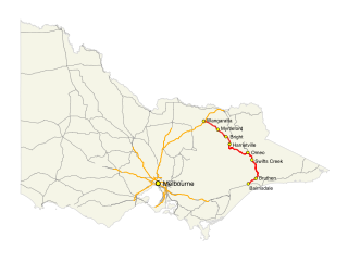
The Great Alpine Road (B500) is a country tourist road in Victoria, Australia, running from Wangaratta in the north to Bairnsdale in the east, and passing through the Victorian Alps. The road was given its current name because it was considered the mountain equivalent to Victoria's world-famous Great Ocean Road in the south-west of the state. The road usually remains open during winter; however, vehicles travelling between Harrietville and Omeo are required to carry diamond-pattern snow chains during the declared snow season.

<span class="mw-page-title-main">Mitchell River (Victoria)</span> River in Victoria, Australia

The Mitchell River is a perennial river of the East Gippsland catchment, located in the Australian state of Victoria. The unregulated river provides a unique example of riparian ecology, flowing generally south with the catchment area drawing from the steep mountains of the Victorian Alps to enter Lake King, one of the Gippsland Lakes, and then empty into the Bass Strait.

<span class="mw-page-title-main">Thomson River (Victoria)</span> River in Victoria, Australia

The Thomson River, a perennial river of the West Gippsland catchment, is located in the Gippsland region of the Australian state of Victoria.

<span class="mw-page-title-main">Bruthen, Victoria</span> Town in Victoria, Australia

Bruthen is a small town located alongside the Tambo River between Bairnsdale and Ensay on the Great Alpine Road in East Gippsland, Victoria, Australia. At the 2016 census, Bruthen had a population of 814. Bruthen is 26 km (16 mi) east of Bairnsdale and 311 km (193 mi) east of the state capital Melbourne.

<span class="mw-page-title-main">Tambo River (Victoria)</span> River in Victoria, Australia

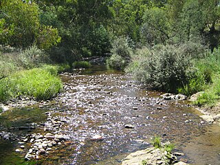
The Tambo River or Berrawan is a perennial river of the Mitchell River catchment, located in the East Gippsland region of the Australian state of Victoria. With a total length in excess of 186 kilometres (116 mi), the Tambo River is one of the longest rivers in the East Gippsland drainage basin, extending from the steep forested southern slopes of the Victorian Alps through forest and farmland to the Gippsland Lakes.

<span class="mw-page-title-main">Shire of Omeo</span> Local government area in Victoria, Australia

The Shire of Omeo was a local government area about 390 kilometres (242 mi) east-north-east of Melbourne, the state capital of Victoria, Australia. The shire covered an area of 5,641 square kilometres (2,178.0 sq mi), and existed from 1872 until 1994.

<span class="mw-page-title-main">Suggan Buggan River</span> River in Victoria, Australia

The Suggan Buggan River is a perennial river of the Snowy River catchment, located in the Alpine region of the Australian state of Victoria.

<span class="mw-page-title-main">Nicholson River (Victoria)</span> River in Victoria, Australia

The Nicholson River is a perennial river of the Mitchell River catchment, located in the East Gippsland region of the Australian state of Victoria.

The Yeerung River is a perennial river located in the East Gippsland region of the Australian state of Victoria.

The Wentworth River is a perennial river of the Mitchell River catchment, located in the East Gippsland region of the Australian state of Victoria.

<span class="mw-page-title-main">Big River (Mitta Mitta River, Victoria)</span> River in Victoria, Australia

The Big River, a perennial river of the North-East Murray catchment of the Murray-Darling basin, is located in the East Gippsland and alpine regions of Victoria, Australia. It flows from the northern slopes of Falls Creek in the Australian Alps, joining with the Cobungra River near Anglers Rest to form the Mitta Mitta River.

<span class="mw-page-title-main">Bundara River</span> River in Victoria, Australia

The Bundara River, a perennial river of the North-East Murray catchment of the Murray-Darling basin, is located in the East Gippsland and alpine regions of Victoria, Australia.

<span class="mw-page-title-main">Moroka River</span> River in Victoria, Australia

The Moroka River is a perennial river of the Mitchell River catchment, located in the Alpine region of the Australian state of Victoria.

The Back River is a perennial river of the Mitchell River catchment, located in the Alpine region of the Australian state of Victoria.

The Little River is a perennial river of the Mitchell River catchment, located in the East Gippsland region of the Australian state of Victoria.

The Dry River is a perennial river of the Mitchell River catchment, located in the Alpine region of the Australian state of Victoria.

The Little River is a perennial river of the Mitchell River catchment, located in the Alpine region of the Australian state of Victoria.

The Gibbo River, a perennial river of the North-East Murray catchment of the Murray-Darling basin, is located in the alpine and East Gippsland regions of Victoria, Australia. It flows from the northwestern slopes of the Australian Alps, south and joins with Morass Creek southeast of Lake Dartmouth.

References

  1. "Timbarra River: 27786". Vicnames. Government of Victoria. 2 May 1966. Archived from the original on 14 January 2014. Retrieved 13 January 2014.
  2. 1 2 3 "Map of Timbarra River, VIC". Bonzle Digital Atlas of Australia. Retrieved 13 January 2014.
  3. 1 2 3 8423 Omeo, Victoria, Topographic Map (Map) (1 ed.). National Topographic Map Series. Commonwealth of Australia. 1982.
  4. 1 2 3 Vicroads Country Street Directory of Victoria (4 ed.). Noble Park, Victoria: Royal Automobile Club of Victoria. 2000. ISSN   1329-5284.
  5. 1 2 "Timbarra River – Tambo Nicholson Catchment". East Gippsland Directories. G.W. & L.A. Keating. Retrieved 21 May 2009.
  6. 1 2 3 "Tambo River Basin – Angling Waters: Timbarra River, Timbarra". Department of Primary Industries Official Website. Government of Victoria. 1996–2012. Retrieved 30 December 2012.
  7. Nicholson/Tambo Map (Map). East Gippsland Catchment Management Authority. Archived from the original on 12 September 2009. Retrieved 21 May 2009.
  8. "Victorian Resources Online: 8523-6 Timbarra River Gorge". Victorian Resources Online: Department of Primary Industries. Government of Victoria. 1996–2009. Retrieved 22 May 2009.
  9. "Tambo River Basin". Department of Primary Industries. Government of Victoria. 1996–2012. Retrieved 30 December 2012.
  10. "Swifts Creek Secondary College – About: Sport". Swifts Creek P-12 School. 2009. Retrieved 30 December 2012.