Nicholson River (Victoria)

Last updated

Nicholson
Nicholson-River-and-road-bridge,-Nicholson,-VIC,-13.09.2008.jpg
Looking south along the river from the East Gippsland Rail Trail trestle bridge at Nicholson.
Australia Victoria relief location map.jpg
Red pog.svg
Location of the Nicholson River mouth in Victoria
EtymologyIn honour of Charles Nicholson [1]
Native name
Location
Country Australia
State Victoria
Region South East Corner (IBRA), East Gippsland
Local government area Shire of East Gippsland
Towns Nicholson
Physical characteristics
SourceAngora Range, Great Dividing Range
  locationbelow Marthavale
  coordinates 37°26′43″S147°31′24″E / 37.44528°S 147.52333°E / -37.44528; 147.52333
  elevation440 m (1,440 ft)
Mouth Lake King to form confluence with the Mitchell River
  location
near Nicholson
  coordinates
37°50′53″S147°43′54″E / 37.84806°S 147.73167°E / -37.84806; 147.73167 Coordinates: 37°50′53″S147°43′54″E / 37.84806°S 147.73167°E / -37.84806; 147.73167
  elevation
0 m (0 ft)
Length83 km (52 mi)
Basin features
River system Mitchell River catchment
Tributaries 
  leftBarmouth Creek, Navigation Creek, Nicholson Creek
  rightBlack Snake Creek, Yahoo Creek, Store Creek
[7] [8]

The Nicholson River is a perennial river of the Mitchell River catchment, located in the East Gippsland region of the Australian state of Victoria. [9]

Contents

Course and features

The Nicholson River rises below the Angora Range in the lower reaches of the Victorian Alps within the Great Dividing Range, near the small settlement of Marthavale, west of Ensay. [10] The river flows generally southeast passing through the small town of Nicholson before entering Lake King, one of the main lakes in the extensive Gippsland Lakes system. [9] Within the lake, the Nicholson River forms its confluence with the Mitchell River, which joins with the Tambo River; with the Mitchell River draining into Bass Strait southwest of Lakes Entrance, in the Shire of East Gippsland. The river descends 440 metres (1,440 ft) over its 83-kilometre (52 mi) course. [8] [11]

The river is impounded by the Nicholson River Dam, that forms a water reservoir used for the supply of town water to Lakes Entrance, until 1995. [12]

In its lower reaches, the river is traversed by the Great Alpine Road, the Princes Highway, and the East Gippsland Rail Trail, [8] a shared purpose rail trail that was formerly the part of the Orbost railway line.

Etymology

There are a number of Australian Aboriginal names for the river including: from the Brabralung language Yowen-burrun [2] and Dart'yung, [3] both meaning "root of water plant"; [4] Geremoot, with no clearly defined meaning; [5] and in the Tatungalung language, Ngarrak walang, meaning "back-stone". [6]

The current name of the river was given by the early colonial explorer and pastoralist, Angus McMillan, who named the river in 1839 in honour of Charles Nicholson, who represented the Port Phillip District on the NSW Legislative Council and was later Colonial Secretary. [1]

See also

Related Research Articles

<span class="mw-page-title-main">Avon River (Gippsland, Victoria)</span> River in the Gippsland region of Victoria, Australia

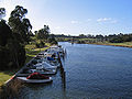
The Avon River is a perennial river of the West Gippsland catchment, located in the West Gippsland region, of the Australian state of Victoria. The Avon, forms an important part of the Latrobe sub-catchment, draining the south eastern slopes of the Great Dividing Range, to form the Gippsland Lakes.

<span class="mw-page-title-main">Mitchell River (Victoria)</span> River in Victoria, Australia

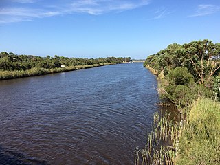
The Mitchell River is a perennial river of the East Gippsland catchment, located in the Australian state of Victoria. The unregulated river provides a unique example of riparian ecology, flowing generally south with the catchment area drawing from the steep mountains of the Victorian Alps to enter Lake King, one of the Gippsland Lakes, and then empty into the Bass Strait.

<span class="mw-page-title-main">Latrobe River</span> River in Victoria, Australia

The Latrobe River is a perennial river of the West Gippsland catchment, located in the West Gippsland region of the Australian state of Victoria. The Latrobe River and its associated sub-catchment is an important source for the Gippsland Lakes, draining the south eastern slopes of the Great Dividing Range.

<span class="mw-page-title-main">Tambo River (Victoria)</span> River in Victoria, Australia

The Tambo River or Berrawan is a perennial river of the Mitchell River catchment, located in the East Gippsland region of the Australian state of Victoria. With a total length in excess of 186 kilometres (116 mi), the Tambo River is one of the longest rivers in the East Gippsland drainage basin, extending from the steep forested southern slopes of the Victorian Alps through forest and farmland to the Gippsland Lakes.

The Timbarra River is a perennial river of the Mitchell River catchment, located in the East Gippsland region of the Australian state of Victoria.

The Albert River is a perennial river of the West Gippsland catchment, located in the South Gippsland region of the Australian state of Victoria.

<span class="mw-page-title-main">Macalister River</span> River in Victoria, Australia

The Macalister River, a perennial river of the West Gippsland catchment, is located in the Alpine and Gippsland regions of the Australian state of Victoria.

The Perry River is a perennial river of the West Gippsland catchment, located in the Gippsland region of the Australian state of Victoria.

<span class="mw-page-title-main">Brodribb River</span> River in Victoria, Australia

The Brodribb River is a perennial river of the Snowy River catchment, located in the East Gippsland region of the Australian state of Victoria.

The Dargo River is a perennial river of the Mitchell River catchment, located in the Alpine and East Gippsland regions of the Australian state of Victoria.

The Wentworth River is a perennial river of the Mitchell River catchment, located in the East Gippsland region of the Australian state of Victoria.

<span class="mw-page-title-main">Buchan River</span> River in Victoria, Australia

The Buchan River is a perennial river of the Snowy River catchment, located in the Alpine region of the Australian state of Victoria.

<span class="mw-page-title-main">Berrima River</span> River in Victoria, Australia

The Berrima River, also called the Berrima Creek, is a perennial river of the Snowy River catchment, located in the Alpine region of the Australian states of New South Wales and Victoria.

The Back River is a perennial river of the Mitchell River catchment, located in the Alpine region of the Australian state of Victoria.

The Little River is a perennial river of the Mitchell River catchment, located in the East Gippsland region of the Australian state of Victoria.

The Wonnangatta River is a perennial river of the Mitchell River catchment, located in the Alpine and East Gippsland regions of the Australian state of Victoria.

The Little Dargo River is a perennial river of the Mitchell River catchment, located in the Alpine region of the Australian state of Victoria.

The Wongungarra River is a perennial river of the Mitchell River catchment, located in the Alpine region of the Australian state of Victoria.

The Crooked River is a perennial river of the Mitchell River catchment, located in the Alpine region of the Australian state of Victoria.

<span class="mw-page-title-main">Aberfeldy River</span> River in Victoria, Australia

The Aberfeldy River is a perennial river of the West Gippsland catchment, located in the Alpine region of the Australian state of Victoria.

References

  1. 1 2 Daley, Charles (1960). The Story of Gippsland. Melbourne: Whitcombe and Tombs. p. 213., cited in Bird, Eric (12 October 2006). "Place Names on the Coast of Victoria" (PDF). The Australian National Placename Survey (ANPS). Archived from the original (PDF) on 10 February 2011. Retrieved 10 February 2011.
  2. 1 2 "Nicholson River: 22494: Traditional Name: Yowen-burrun". Vicnames. Government of Victoria. 12 August 2011. Archived from the original on 15 January 2014. Retrieved 13 January 2014.
  3. 1 2 "Nicholson River: 22494: Traditional Name: Dart'yung". Vicnames. Government of Victoria. 12 August 2011. Archived from the original on 15 January 2014. Retrieved 13 January 2014.
  4. 1 2 "Nicholson River: 22494: Traditional Name: Dart'yung". Vicnames. Government of Victoria. 12 August 2011. Archived from the original on 15 January 2014. Retrieved 13 January 2014.
  5. 1 2 "Nicholson River: 22494: Traditional Name: Geremoot". Vicnames. Government of Victoria. 12 August 2011. Archived from the original on 15 January 2014. Retrieved 13 January 2014.
  6. 1 2 "Nicholson River: 22494: Traditional Name: Ngarrak walang". Vicnames. Government of Victoria. 12 August 2011. Archived from the original on 15 January 2014. Retrieved 13 January 2014.
  7. "Nicholson River: 22494". Vicnames. Government of Victoria. 2 May 1966. Archived from the original on 15 January 2014. Retrieved 13 January 2014.
  8. 1 2 3 "Map of Nicholson River, VIC". Bonzle Digital Atlas of Australia. Retrieved 13 January 2014.
  9. 1 2 Vicroads Country Street Directory of Victoria (4 ed.). Noble Park, Victoria: Royal Automobile Club of Victoria. 2000. ISSN   1329-5284.
  10. 8423 Omeo, Victoria, Topographic Map. National Topographic Map Series (1 ed.). Commonwealth of Australia. 1982.
  11. "Nicholson / Tambo Catchments" (PDF). Official Website. East Gippsland Catchment Management Authority. Archived from the original on 18 February 2011. Retrieved 13 May 2009.
  12. "Nicholson River Dam decommissioning mooted". Australia: ABC News. 21 December 2010. Retrieved 13 January 2014.