The Rubicon River, an inland perennial river of the Goulburn Broken catchment, part of the Murray-Darling basin, is located in the lower South Eastern Highlands bioregion and Northern Country/North Central regions of the Australian state of Victoria. The headwaters of the Rubicon River rise on the western slopes of the Victorian Alps and descend to flow into the Goulburn River.
The Delatite River, an inland perennial river of the Goulburn Broken catchment, part of the Murray-Darling basin, is located in the lower South Eastern Highlands bioregion and Northern Country/North Central regions of the Australian state of Victoria. The headwaters of the Delatite River rise on the western slopes of the Victorian Alps and descend to flow into the Goulburn River within Lake Eildon.

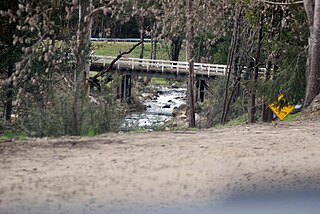
The Rubicon Hydroelectric Scheme is a small run-of-the-river hydroelectric scheme located on the Rubicon and Royston Rivers, north east of Melbourne, 40 km (25 mi) south-west of Alexandra, Victoria, Australia. The scheme commenced in 1922, and was the first state-owned hydroelectric scheme to generate electricity in mainland Australia, and among the first in the world to be remotely controlled. For the first ten years of its operation it supplied on average 16.9% of electricity generated by the State Electricity Commission of Victoria. It is now owned and operated by AGL Energy and contributes approximately 0.02% of Victoria's energy supply.

The Little Yarra River is a perennial river of the Port Phillip catchment, located in the Greater Metropolitan Melbourne region of the Australian state of Victoria.
The Dargo River is a perennial river of the Mitchell River catchment, located in the Alpine and East Gippsland regions of the Australian state of Victoria.
The Acheron River, a minor inland perennial river of the Goulburn Broken catchment, part of the Murray-Darling basin, is located in the lower South Eastern Highlands bioregion and Northern Country/North Central regions of the Australian state of Victoria. The headwaters of the Acheron River rise on the north–western slopes of the Yarra Ranges, below The Knobs and descend to flow into the Goulburn River near Alexandra.

The Moroka River is a perennial river of the Mitchell River catchment, located in the Alpine region of the Australian state of Victoria.
The Little River, a perennial river that is part of the Hawkesbury-Nepean catchment, is located in the Central Tablelands region of New South Wales, Australia.
The Little Dargo River is a perennial river of the Mitchell River catchment, located in the Alpine region of the Australian state of Victoria.
The Little River is a perennial river of the Mitchell River catchment, located in the Alpine region of the Australian state of Victoria.
The Humffray River is a perennial river of the Mitchell River catchment, located in the Alpine region of the Australian state of Victoria.
The Don River is a perennial river of the Port Phillip catchment, located in the Central region of the Australian state of Victoria.
The Little River, a minor inland perennial river of the Goulburn Broken catchment, part of the Murray-Darling basin, is located in the lower South Eastern Highlands bioregion and Northern Country/North Central regions of the Australian state of Victoria. The headwaters of the Little River rise below the Cathedral Range and descend to flow into the Acheron River at Taggerty.
The Taggerty River, a minor inland perennial river of the Goulburn Broken catchment, part of the Murray-Darling basin, is located in the lower South Eastern Highlands bioregion and Northern Country/North Central regions of the Australian state of Victoria. The headwaters of the Taggerty River rise on the north–western slopes of the Yarra Ranges, below Lake Mountain and descend to flow into the Steavenson River near Marysville.

The Big River, an inland perennial river of the Goulburn Broken catchment, part of the Murray-Darling basin, is located in the lower South Eastern Highlands bioregion and Northern Country/North Central regions of the Australian state of Victoria. The headwaters of the Big River rise on the northern slopes of the Yarra Ranges and descend to flow into the Goulburn River within Lake Eildon.
The Black River, an inland perennial river of the Goulburn Broken catchment, part of the Murray-Darling basin, is located in the lower South Eastern Highlands bioregion and Northern Country/North Central regions of the Australian state of Victoria. The headwaters of the Black River rise on the northern slopes of the Yarra Ranges and descend to flow into the Goulburn River within the Yarra Ranges National Park.
The Murrindindi River, an inland perennial river of the Goulburn Broken catchment, part of the Murray-Darling basin, is located in the lower South Eastern Highlands bioregion and Northern Country/North Central regions of the Australian state of Victoria. The headwaters of the Murrindindi River rise on the western slopes of the Victorian Alps and descend to flow into the Yea River.
The Royston River, an inland perennial river of the Goulburn Broken catchment, part of the Murray-Darling basin, is located in the lower South Eastern Highlands bioregion and Northern Country/North Central regions of the Australian state of Victoria. The headwaters of the Royston River rise on the western slopes of the Victorian Alps and descend to flow into the Rubicon River.
The Little Coliban River, a minor inland perennial river of the north–central catchment, part of the Murray-Darling basin, is located in the lower Riverina bioregion and Central Highlands region of the Australian state of Victoria. The headwaters of the Little Coliban River rise on the northern slopes of the Great Dividing Range and descend to flow north into the Coliban River within the impounded Upper Coliban Reservoir.
The Mackenzie River, an inland intermittent river of the Wimmera catchment, is located in the Grampians region of the Australian state of Victoria. Rising in the Grampians National Park, on the northern slopes of the Great Dividing Range, the Mackenzie River flows generally north by west and drains into the Wimmera River, southwest of Horsham.
