North Central Victoria

Last updated

North Central
Victoria
BendigoCapitalTheatre.JPG
Originally a Masonic Hall, now the Capital Theatre in Bendigo.
Seymour-aerial.jpg
An aerial view of Seymour showing Goulburn River to the left.
Australia Victoria relief location map.jpg
Red pog.svg
North Central
The location of Bendigo, the major city in the North Central region
Coordinates 36°45′S144°16′E / 36.750°S 144.267°E / -36.750; 144.267
Population249,660 (2016 census) [Note 1]
 • Density5.33895/km2 (13.8278/sq mi)
Area46,762 km2 (18,054.9 sq mi)
Time zone AEST (UTC+10)
 • Summer (DST) AEDT (UTC+11)
Location150 km (93 mi) NW of Melbourne
LGA(s)
State electorate(s)
Federal division(s)
Localities around North Central:
Mallee New South Wales Hume
Mallee North Central Central Highlands
Wimmera Greater Melbourne Central Highlands

North Central Victoria is a rural region in the Australian state of Victoria. The region lies to the south of the Victorian/New South Wales border as defined by the Murray River, to the southwest of the Hume region, to the west of the Great Dividing Range contained within the Central Highlands and Victorian Alps, to the north of Greater Melbourne, to the northeast of the Wimmera, and to the east of the Mallee region.

Contents

As at the 2016 Australian census, the North Central region had a population of 249,660, representing the aggregate population of the eight local government areas that comprise the region.

Location

Sustainability Victoria, a Victorian Government agency, defines North Central Victoria as the municipalities of Buloke, Gannawarra, Loddon, Campaspe, Central Goldfields, Mount Alexander, Macedon Ranges and the City of Greater Bendigo. [1] A climate change study by La Trobe University also includes the Shire of Hepburn within the region. [2]

The major urban centres are Bendigo, Castlemaine, Maryborough and Rochester. Smaller localities include Kyneton, Pyramid Hill, Kerang, Donald and Creswick. In 2002 the estimated population of North Central Victoria was 200,000. [2]

Administration

Political representation

For the purposes of Australian federal elections for the House of Representatives, the North Central region is contained within the Division of Bendigo, [3] a southwestern portion of the Division of McEwen, [4] the westernmost portion of the Division of Murray, [5] the northeasternmost portion of the Division of Mallee, [6] and the northeasternmost portion of the Division of Wannon, [7]

For the purposes of Victorian elections for the Legislative Assembly, the North Central region is contained within the electoral districts of Bendigo East, Bendigo West, Macedon, Murray Plains and Ripon.

Local government areas

For administration purposes the region is divided into eight local government areas:

North Central region LGA populations
Local government area AreaPopulation
(2011 census)
Source(s)Population
(2016 census)
Source(s)
km2sq mi
City of Greater Bendigo 3,0481,177100,617 [8] 110,477 [9]
Buloke Shire 8,0043,0906,384 [10] 6,201 [11]
Shire of Campaspe 1,28049036,365 [12] 37,061 [13]
Central Goldfields Shire 20,9418,08512,496 [14] 12,995 [15]
Gannawarra Shire 3,7321,44110,366 [16] 10,549 [17]
Shire of Loddon 6,6942,5857,459 [18] 7,516 [19]
Shire of Macedon Ranges 1,53459248,160 [20] 46,100 [21]
Shire of Mount Alexander 1,52959017,591 [22] 18,761 [23]
Totals46,76218,055239,438249,660

Environmental protection

The North Central region contains the Greater Bendigo National Park, Gunbower National Park, Heathcote-Graytown National Park, and the Terrick Terrick National Park.

Climate

The climate is moderate with wet winters and warm, dry summers. Annual rainfall ranges from 350 millimetres (14 in) near Swan Hill in the north, to over 1,200 millimetres (47 in) in the far southeast.

Temperatures are warm in summer, typically ranging from a maximum of 31 °C (88 °F) to a minimum of 14 °C (57 °F) in Kerang in the northwest and from 27 °C (81 °F) to 11 °C (52 °F) in the south. Winters are cool with minimum temperatures of 2–4 °C (36–39 °F) across the region. [24]

Natural resources

Natural resource management is administered by the North Central Catchment Management Authority covering 30,000 kilometres (19,000 mi) bounded by the Great Dividing Range, the Mount Carmel Ranges to the east and the New South Wales border to the north. [25] This includes the management of rural water allocations and environmental protection for the Avon-Richardson, Avoca, Campaspe and Loddon rivers. [26]

Regional water consumption for irrigation, stock and domestic use greatly exceeds local supply. Irrigation consumes an average 1.4 gigalitres (310×10^6 imp gal; 370×10^6 US gal) per annum, while domestic use consumes around 40,000 megalitres (8,800,000×10^3 imp gal; 11,000,000×10^3 US gal) per annum. [24] More than 75% of regional water needs are met from water imports from the Goulburn Valley and upper Murray River catchments to the north and west. [26]

An extensive network of natural lakes includes Lake Buloke (the terminus for the Avon-Richardson River), Lake Batyo Catyo near the town of Donald, and a northern network comprising Lakes Boort, Merna, Kangaroo, Charm, Lalbert and Boga. [24] Groundwater beneath this northern lakes network supplies approximately 80% of Australia's mineral springs, supplying the bulk of domestically produced mineral water and providing substantial local employment. [24]

Land use

The predominant land use is agriculture, including sheep and cattle grazing and the production of cereals, grains and legumes. The gross value of agricultural output exceeds $0.8 billion a year. [24] Forestry is also a major employer in the area surrounding the former gold rush towns of Creswick and Daylesford, [27] with a substantial output of firewood, furniture timber and Eucalyptus oil. [24]

Approximately 13% of the North Central catchment is public land, comprising flora reserves and state and national parks. [27]

Notes

  1. Population figure is the combined population of all LGAs in the region

Related Research Articles

<span class="mw-page-title-main">Bendigo</span> City in Victoria, Australia

Bendigo is a city in Victoria, Australia, located in the Bendigo Valley near the geographical centre of the state and approximately 150 kilometres (93 mi) north-west of Melbourne, the state capital.

<span class="mw-page-title-main">Gippsland</span> Region in Victoria, Australia

Gippsland is a rural region that makes up the southeastern part of Victoria, Australia, mostly comprising the coastal plains to the rainward (southern) side of the Victorian Alps. It covers an elongated area of 41,556 km2 (16,045 sq mi) located further east of the Shire of Cardinia between Dandenong Ranges and Mornington Peninsula, and is bounded to the north by the mountain ranges and plateaus/highlands of the High Country, to the southwest by the Western Port Bay, to the south and east by the Bass Strait and the Tasman Sea, and to the east and northeast by the Black-Allan Line.

<span class="mw-page-title-main">City of Greater Bendigo</span> Local government area in Victoria, Australia

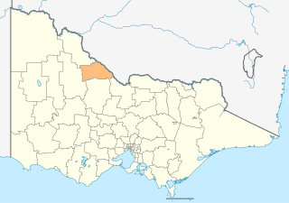
The City of Greater Bendigo is a local government area in Victoria, Australia, located in the central part of the state. It covers an area of 3,000 square kilometres (1,200 sq mi) and, in August 2021, had a population of 121,470. It includes the city of Bendigo and the towns of Axedale, Elmore, Heathcote, Marong, Raywood and Strathfieldsaye. It was formed in 1994 from the amalgamation of the former City of Bendigo with the Borough of Eaglehawk, Shire of Strathfieldsaye, Shire of Huntly, Rural City of Marong and parts of the Shire of McIvor. It is the state’s third largest economy base and is considered a service and infrastructure centre for north central Victoria. The city is surrounded by 40,000 hectares of regional, state and national parkland.

<span class="mw-page-title-main">Shire of Buloke</span> Local government area in Victoria, Australia

The Shire of Buloke is a local government area in Victoria, Australia, located in the western part of the state. It covers an area of 8,000 square kilometres (3,100 sq mi) and, in August 2021, had a population of 6,201. It includes the towns of Birchip, Charlton, Donald, Sea Lake and Wycheproof. It was formed in 1995 from the amalgamation of the Shire of Wycheproof, Shire of Birchip, Shire of Charlton, Shire of Donald, and parts of the Shire of Kara Kara.

<span class="mw-page-title-main">Shire of Campaspe</span> Local government area in Victoria, Australia

The Shire of Campaspe is a local government area in Victoria, Australia, located in the northern part of the state. It covers an area of 4,519 square kilometres (1,745 sq mi) and in August 2021 had a population of 38,735.

<span class="mw-page-title-main">Shire of Gannawarra</span> Local government area in Victoria, Australia

The Shire of Gannawarra is a local government area in Victoria, Australia, located in the northern part of the state. It covers an area of 3,735 square kilometres (1,442 sq mi) and, in August 2021 had a population of 10,683.

<span class="mw-page-title-main">Wimmera Southern Mallee (region)</span> Region in Victoria, Australia

The Victorian government's Wimmera Southern Mallee subregion is part of the Grampians region in western Victoria. It includes most of what is considered the Wimmera, and part of the southern Mallee region. The subregion is based on the social catchment of Horsham, its main settlement.

<span class="mw-page-title-main">Rochester, Victoria</span> Australian town

Rochester is a small town in rural Victoria, Australia. It is located 180 km (110 mi) north of Melbourne with a mixture of rural and semi-rural communities on the northern Campaspe River, between Bendigo and the Murray River port of Echuca. At the 2021 census, Rochester had a population of 3,154.

<span class="mw-page-title-main">Mallee (region, Victoria)</span> Region of Victoria, Australia

The Mallee is a sub-region of Loddon Mallee covering the most north-westerly part of Victoria, Australia and is bounded by the South Australian and New South Wales borders. Definitions of the south-eastern boundary vary, however, all are based on the historic Victorian distribution of mallee eucalypts. These trees dominate the surviving vegetation through most of Mallee,. Its biggest settlements are Mildura and Swan Hill.

<span class="mw-page-title-main">Birchip, Victoria</span> Town in Victoria, Australia

Birchip is a town in the Mallee region of Victoria, Australia on the Sunraysia Highway north of Donald. The town is located in the Shire of Buloke local government area. At the 2021 census, Birchip had a population of 694, down from the 2016 figure of 702. It has a P-12 school, and an Australian rules football club called Birchip-Watchem, also known as the Birchip-Watchem Bulls, or just the "Bulls".

<span class="mw-page-title-main">Bridgewater On Loddon, Victoria</span> Town in Victoria, Australia

Bridgewater On Loddon is a town in north central Victoria, Australia. The town is located on the Calder Highway, north-west of Bendigo, astride the Loddon River. At the 2016 census, Bridgewater On Loddon had a population of 326. The rural area which surrounds Bridgewater on Loddon is named simply "Bridgewater".

<span class="mw-page-title-main">Coliban River</span> River in Victoria, Australia

The Coliban River, an inland perennial river of the north–central catchment, part of the Murray-Darling basin, is located in the lower Riverina bioregion and Central Highlands region of the Australian state of Victoria. The headwaters of the Coliban River rise on the northern slopes of the Great Dividing Range and descend to flow north into the Campaspe River with the impounded Lake Eppalock.

The regions of Victoria vary according to the different ways that the Australian state of Victoria is divided into distinct geographic regions. The most commonly used regions are those created by the state government for the purposes of economic development.

<span class="mw-page-title-main">Toolleen</span> Town in Victoria, Australia

Toolleen is a town in northern Victoria, Australia. The town is on the Northern Highway and is in the Shire of Campaspe and the City of Greater Bendigo local government areas, 142 kilometres (88 mi) north of the state capital, Melbourne. At the 2016 census, Toolleen and the surrounding area had a population of 182.

<span class="mw-page-title-main">Hume (region)</span> Region in Victoria, Australia

The Hume is an economic rural region located in the north-eastern part of Victoria, Australia. Comprising an area in excess of 40,000 square kilometres (15,000 sq mi) with a population that ranges from 263,000 to 300,000, the Hume region includes the local government areas of Alpine Shire, Rural City of Benalla, City of Wodonga, City of Greater Shepparton, Shire of Indigo, Shire of Mansfield, Shire of Strathbogie, Shire of Towong and the Rural City of Wangaratta, and also includes five unincorporated areas encompassing the alpine ski resorts in the region.

<span class="mw-page-title-main">Grampians (region)</span> Economic region of Victoria, Australia

The Grampians is an economic rural region located in the western part of Victoria, Australia. The 48,646-square-kilometre (18,782 sq mi) region lies to the northwest of the western suburbs of Greater Melbourne, to the state's western border with South Australia and includes the Grampians National Park and significant gold mining heritage assets. The Grampians region has two sub-regions, Grampians Central Highlands and Wimmera Southern Mallee.

<span class="mw-page-title-main">Barwon South West (region)</span> Region in Victoria, Australia

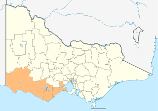
The Barwon South West is an economic rural region located in the southwestern part of Victoria, Australia. The Barwon South West region stretches from the tip of the Queenscliff Heads to the border of South Australia. It is home to Victoria’s largest provincial centre, Geelong and the major centres of Aireys Inlet, Apollo Bay, Camperdown, Colac, Hamilton, Lorne, Port Campbell, Port Fairy, Portland, Torquay and Warrnambool. It draws its name from the Barwon River and the geographic location of the region in the state of Victoria.

<span class="mw-page-title-main">Campaspe River</span> River in Victoria, Australia

The Campaspe River, an inland intermittent river of the north–central catchment, part of the Murray-Darling basin, is located in the lower Riverina bioregion and Central Highlands and Wimmera regions of the Australian state of Victoria. The headwaters of the Campaspe River rise on the northern slopes of the Great Dividing Range and descend to flow north into the Murray River, Australia's longest river, near Echuca.

<span class="mw-page-title-main">Loddon Mallee</span> Economic region of Victoria, Australia

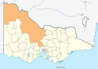
The Loddon Mallee is an economic rural region located in the north-western part of Victoria, Australia. Occupying more than a quarter of the state, it stretches from Greater Melbourne to the northernmost point of Victoria, sharing a border with South Australia and New South Wales, and has one of the most consistently warm climates in Victoria. It has two major regional cities Bendigo and Mildura and also contains the major settlements of Castlemaine, Echuca, Gisborne, Kerang, Kyneton, Maryborough, Swan Hill, Wedderburn and Wycheproof.

References

  1. "North Central Victoria". Sustainability Victoria. August 2006. Retrieved 7 January 2008.
  2. 1 2 "The Energy Footprint for North Central Victoria: An Initial Step Toward Addressing Climate Change" (PDF). University of LaTrobe. 2002. Retrieved 7 January 2008.
  3. "Profile of the electoral division of Bendigo (Vic)". Current federal electoral divisions. Australian Electoral Commission. 24 December 2010. Retrieved 9 August 2014.
  4. "Profile of the electoral division of McEwen (Vic)". Current federal electoral divisions. Australian Electoral Commission. 24 December 2010. Retrieved 9 August 2014.
  5. "Profile of the electoral division of Murray (Vic)". Current federal electoral divisions. Australian Electoral Commission. 24 December 2010. Retrieved 9 August 2014.
  6. "Profile of the electoral division of Mallee (Vic)". Current federal electoral divisions. Australian Electoral Commission. 24 December 2010. Retrieved 9 August 2014.
  7. "Profile of the electoral division of Wannon (Vic)". Current federal electoral divisions. Australian Electoral Commission. 24 December 2010. Retrieved 9 August 2014.
  8. Australian Bureau of Statistics (31 October 2012). "2011 Community Profiles: Greater Bendigo (C) (Local Government Area)". 2011 Census of Population and Housing. Retrieved 9 August 2014. OOjs UI icon edit-ltr-progressive.svg
  9. Australian Bureau of Statistics (27 June 2017). "2016 Community Profiles: Greater Bendigo (C) (Local Government Area)". 2016 Census of Population and Housing. Retrieved 3 April 2018. OOjs UI icon edit-ltr-progressive.svg
  10. Australian Bureau of Statistics (31 October 2012). "2011 Community Profiles: Buloke (S) (Local Government Area)". 2011 Census of Population and Housing. Retrieved 9 August 2014. OOjs UI icon edit-ltr-progressive.svg
  11. Australian Bureau of Statistics (27 June 2017). "2016 Community Profiles: Buloke (S) (Local Government Area)". 2016 Census of Population and Housing. Retrieved 3 April 2018. OOjs UI icon edit-ltr-progressive.svg
  12. Australian Bureau of Statistics (31 October 2012). "2011 Community Profiles: Campaspe (S) (Local Government Area)". 2011 Census of Population and Housing. Retrieved 9 August 2014. OOjs UI icon edit-ltr-progressive.svg
  13. Australian Bureau of Statistics (27 June 2017). "2016 Community Profiles: Campaspe (S) (Local Government Area)". 2016 Census of Population and Housing. Retrieved 3 April 2018. OOjs UI icon edit-ltr-progressive.svg
  14. Australian Bureau of Statistics (31 October 2012). "2011 Community Profiles: Central Goldfields (S) (Local Government Area)". 2011 Census of Population and Housing. Retrieved 9 August 2014. OOjs UI icon edit-ltr-progressive.svg
  15. Australian Bureau of Statistics (27 June 2017). "2016 Community Profiles: Central Goldfields (S) (Local Government Area)". 2016 Census of Population and Housing. Retrieved 3 April 2018. OOjs UI icon edit-ltr-progressive.svg
  16. Australian Bureau of Statistics (31 October 2012). "2011 Community Profiles: Gannawarra (S) (Local Government Area)". 2011 Census of Population and Housing. Retrieved 9 August 2014. OOjs UI icon edit-ltr-progressive.svg
  17. Australian Bureau of Statistics (27 June 2017). "2016 Community Profiles: Gannawarra (S) (Local Government Area)". 2016 Census of Population and Housing. Retrieved 3 April 2018. OOjs UI icon edit-ltr-progressive.svg
  18. Australian Bureau of Statistics (31 October 2012). "2011 Community Profiles: Loddon (S) (Local Government Area)". 2011 Census of Population and Housing. Retrieved 9 August 2014. OOjs UI icon edit-ltr-progressive.svg
  19. Australian Bureau of Statistics (27 June 2017). "2016 Community Profiles: Loddon (S) (Local Government Area)". 2016 Census of Population and Housing. Retrieved 3 April 2018. OOjs UI icon edit-ltr-progressive.svg
  20. Australian Bureau of Statistics (31 October 2012). "2011 Community Profiles: Macedon Ranges (S) (Local Government Area)". 2011 Census of Population and Housing. Retrieved 9 August 2014. OOjs UI icon edit-ltr-progressive.svg
  21. Australian Bureau of Statistics (27 June 2017). "2016 Community Profiles: Macedon Ranges (S) (Local Government Area)". 2016 Census of Population and Housing. Retrieved 3 April 2018. OOjs UI icon edit-ltr-progressive.svg
  22. Australian Bureau of Statistics (31 October 2012). "2011 Community Profiles: Mount Alexander (S) (Local Government Area)". 2011 Census of Population and Housing. Retrieved 9 August 2014. OOjs UI icon edit-ltr-progressive.svg
  23. Australian Bureau of Statistics (27 June 2017). "2016 Community Profiles: Mount Alexander (S) (Local Government Area)". 2016 Census of Population and Housing. Retrieved 3 April 2018. OOjs UI icon edit-ltr-progressive.svg
  24. 1 2 3 4 5 6 "North Central Regional Catchment Strategy 2003-2007". North Central Catchment Management Authority. 2003. Retrieved 7 January 2008.
  25. "Welcome to the North Central Catchment Management Authority". North Central Catchment Management Authority. December 2007. Retrieved 7 January 2008.
  26. 1 2 "Natural Resource Management Assets: Water". North Central Catchment Management Authority. December 2007. Retrieved 7 January 2008.
  27. 1 2 "North Central Land Use". Department of Primary Industries, Victoria. November 2007. Retrieved 7 January 2008.