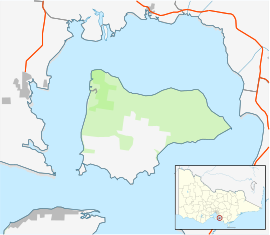
French Island is the largest coastal island of Victoria, Australia, located in Western Port, 61 km (38 mi) southeast of Melbourne. In 1997, about 70% of the island was declared the French Island National Park, administered by Parks Victoria, and was listed in the former Register of the National Estate in 1984. The island is an unincorporated area under the direct administration of the government of Victoria, and is a declared locality of Victoria having its own postcode. Community issues are dealt by the French Island Community Association. The island is otherwise administered by the Department of Transport (Victoria). The population of the island in 2011 was around 116 people, of which about 60 were permanent residents. By 2021 the population on census night was recorded as 139 with a median age of 52 years.

Port Phillip or Port Phillip Bay is a horsehead-shaped enclosed bay on the central coast of southern Victoria, Australia. The bay opens into the Bass Strait via a short, narrow channel known as The Rip, and is completely surrounded by localities of Victoria's two largest cities — metropolitan Greater Melbourne in the bay's main eastern portion north of the Mornington Peninsula, and the city of Greater Geelong in the much smaller western portion north of the Bellarine Peninsula. Geographically, the bay covers 1,930 km2 (750 sq mi) and the shore stretches roughly 264 km (164 mi), with the volume of water around 25 km3 (6.0 cu mi). Most of the bay is navigable, although it is extremely shallow for its size — the deepest portion is only 24 m (79 ft) and half the bay is shallower than 8 m (26 ft). Its waters and coast are home to seals, whales, dolphins, corals and many kinds of seabirds and migratory waders.

Phillip Island is an Australian island about 125 km (78 mi) south-southeast of Melbourne, Victoria. The island is named after Governor Arthur Phillip, the first Governor of New South Wales, by explorer and seaman George Bass, who sailed in an whaleboat, arriving from Sydney on 5 January 1798.

HMAS Otama was an Oberon-class submarine of the Royal Australian Navy (RAN). Built in Scotland, the submarine was the last of the class to enter service when commissioned into the RAN in 1978. Otama was a specialist, one of two "Mystery Boats", fitted with additional surveillance and intelligence-gathering equipment. Otama was routinely deployed on classified operations to obtain intelligence on Soviet Pacific Fleet vessels and Chinese Navy vessels, and conducted associated coastal surveillance, throughout Asia.

The City of Casey is a local government area in Victoria, Australia in the outer south-eastern suburbs of Melbourne. Casey is Victoria's most populous municipality, with a June 2018 population of 340,419. It has an area of 409 square kilometres (157.9 sq mi).

The Mornington Peninsula is a peninsula located south of Melbourne, Victoria, Australia. It is surrounded by Port Phillip to the west, Western Port to the east and Bass Strait to the south, and is connected to the mainland in the north. Geographically, the peninsula begins its protrusion from the mainland in the area between Pearcedale and an area north of Frankston. The area was originally home to the Mayone-bulluk and Boonwurrung-Balluk clans and formed part of the Boonwurrung nation's territory prior to European settlement.

Frankston is a suburb in Melbourne, Victoria, Australia, 41 km (25 mi) south-east of Melbourne's Central Business District, located within the City of Frankston local government area. Frankston recorded a population of 37,331 at the 2021 census.

Arthurs Seat is a mountainous and small locality on the Mornington Peninsula in Melbourne, Victoria, Australia, about 85 km south east of Melbourne's Central Business District, located within the Shire of Mornington Peninsula local government area. Arthurs Seat recorded a population of 414 at the 2021 census.

Crib Point is a town on the Mornington Peninsula in Melbourne, Victoria, Australia, 64 km (40 mi) south-east of Melbourne's Central Business District, located within the Shire of Mornington Peninsula local government area. Crib Point recorded a population of 3,343 at the 2021 census.

Dromana is a seaside suburb on the Mornington Peninsula in Melbourne, Victoria, Australia, 57 km (35 mi) south of Melbourne's Central Business District, located within the Shire of Mornington Peninsula local government area. Dromana recorded a population of 6,626 at the 2021 census.

Flinders is a seaside town on the Mornington Peninsula in Melbourne, Victoria, Australia, 73 km (45 mi) south of Melbourne's Central Business District, located within the Shire of Mornington Peninsula local government area. Flinders recorded a population of 1,130 at the 2021 census.

Portsea is a seaside town on the Mornington Peninsula in Melbourne, Victoria, Australia, approximately 60 kilometres (37 mi) south-west of Melbourne's Central Business District, located within the Shire of Mornington Peninsula local government area. Portsea recorded a population of 787 at the 2021 census.
Western Port, commonly but unofficially known as Western Port Bay, is a large tidal bay in southern Victoria, Australia, opening into Bass Strait. It is the second largest bay in the state. Geographically, it is dominated by two large islands; French Island and Phillip Island. At the time it was renamed, its position was west of other known ports and bays, but Western Port has become something of a misnomer as it lies just to the east of the larger Port Phillip and the city of Melbourne. It is visited by Australian fur seals, whales and dolphins, as well as many migratory waders and seabirds. It is listed under the Ramsar Convention as a wetland of international significance.

The Mornington Peninsula Freeway is a freeway in Melbourne, Victoria, Australia, that provides a link from south-eastern suburban Melbourne to the Mornington Peninsula. Whilst the entire freeway from Dingley Village to Rosebud is declared by VicRoads as the Mornington Peninsula Freeway, the section between EastLink in Carrum Downs and Moorooduc Highway in Moorooduc is locally and commonly known as Peninsula Link. The entire freeway corridor bears the designation M11.

Point Nepean marks the southern point of The Rip and the most westerly point of the Mornington Peninsula, in Victoria, Australia. It was named in 1802 after the British politician and colonial administrator Sir Evan Nepean by John Murray in HMS Lady Nelson. Its coast and adjacent waters are included in the Port Phillip Heads Marine National Park, while its land area is part of the Point Nepean National Park. The point includes Cheviot Beach on its southern side, notable as the site of the disappearance in 1967 of Australia's then-Prime Minister Harold Holt.

The Wellesley Islands, also known as the North Wellesley Islands, is a group of islands off the coast of Far North Queensland, Australia, in the Gulf of Carpentaria. It is a locality within the Shire of Mornington local government area. The traditional owners of the islands are the Lardil people. In the 2016 census, the Wellesley Islands had a population of 1,136 people, all living on the largest island, Mornington Island.

The Bellarine Peninsula is a peninsula located south-west of Melbourne in Victoria, Australia, surrounded by Port Phillip, Corio Bay and Bass Strait. The peninsula, together with the Mornington Peninsula, separates Port Phillip Bay from Bass Strait. The peninsula itself was originally occupied by Indigenous Australian clans of the Wathaurong nation, prior to European settlement in the early 19th century. Early European settlements were initially centred on wheat and grain agriculture, before the area became a popular tourist destination with most visitors arriving by paddle steamer on Port Phillip in the late 19th century.

Frankston Football Club, nicknamed the Dolphins, is an Australian rules football club based in Frankston, Victoria. The club, formed in 1887, has played in the Victorian Football Association/League almost continuously since 1966.

Mornington Peninsula and Western Port Biosphere Reserve is a biosphere reserve in the Australian state of Victoria located on land and coastal waters associated both with the Mornington Peninsula and the bay known as Western Port.

The Gurdies is a village located in Bass Coast Shire in Victoria, Australia.