Beveridge Island (Victoria)

Last updated

Beveridge Island
Victoria
Australia Victoria location map.svg
Red pog.svg
Beveridge Island
Coordinates 35°13′S143°34′E / 35.217°S 143.567°E / -35.217; 143.567 Coordinates: 35°13′S143°34′E / 35.217°S 143.567°E / -35.217; 143.567
LGA(s) Rural City of Swan Hill
Lands administrative divisions around Beveridge Island:
Speewa, New South Wales
Speewa, Victoria Beveridge Island
Tyntynder

Beveridge Island is an island in Victoria, Australia, within the locality of Tyntynder in the Rural City of Swan Hill.

Victoria (Australia) State in Australia

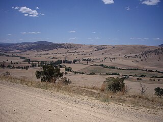
Victoria is a state in south-eastern Australia. Victoria is Australia's smallest mainland state and its second-most populous state overall, making it the most densely populated state overall. Most of its population lives concentrated in the area surrounding Port Phillip Bay, which includes the metropolitan area of its state capital and largest city, Melbourne, Australia's second-largest city. Victoria is bordered by Bass Strait and Tasmania to the south, New South Wales to the north, the Tasman Sea, to the east, and South Australia to the west.

Australia Country in Oceania

Australia, officially the Commonwealth of Australia, is a sovereign country comprising the mainland of the Australian continent, the island of Tasmania, and numerous smaller islands. It is the largest country in Oceania and the world's sixth-largest country by total area. The neighbouring countries are Papua New Guinea, Indonesia, and East Timor to the north; the Solomon Islands and Vanuatu to the north-east; and New Zealand to the south-east. The population of 26 million is highly urbanised and heavily concentrated on the eastern seaboard. Australia's capital is Canberra, and its largest city is Sydney. The country's other major metropolitan areas are Melbourne, Brisbane, Perth, and Adelaide.

Tyntynder, Victoria Town in Victoria, Australia

Tyntynder is a town in the south-east of the Mallee region of Victoria, Australia. It has an Australian rules football team in the Central Murray Football League. Tyntynder post office opened on 4 May 1894, then it was renamed Nyah Post Office 1 November 1894, but closed on 8 August 1944. At the 2016 census, Tyntynder and the surrounding area had a population of 151.

Contents

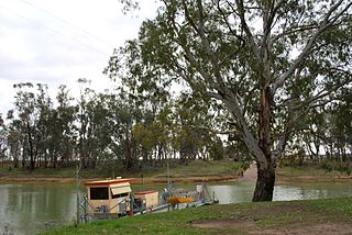
It is enclosed by the Murray River, and an anabranch of the river in the south and has an area of approximately 1116 hectares.

Murray River the longest river in Australia

The Murray River is Australia's longest river, at 2,508 kilometres (1,558 mi) in length. The Murray rises in the Australian Alps, draining the western side of Australia's highest mountains, and then meanders across Australia's inland plains, forming the border between the states of New South Wales and Victoria as it flows to the northwest into South Australia. It turns south at Morgan for its final 315 kilometres (196 mi), reaching the ocean at Lake Alexandrina.

Anabranch A section of a river or stream that diverts from the main channel and rejoins it downstream.

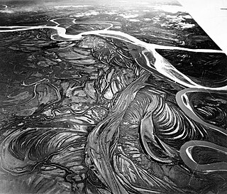
An anabranch is a section of a river or stream that diverts from the main channel or stem of the watercourse and rejoins the main stem downstream. Local anabranches can be the result of small islands in the watercourse. In larger anabranches, the flow can diverge for a distance of several kilometers before rejoining the main channel.

There are no road crossings to the island over the Murray from New South Wales, or from Victoria.

New South Wales State of Australia

New South Wales is a state on the east coast of Australia. It borders Queensland to the north, Victoria to the south, and South Australia to the west. Its coast borders the Tasman Sea to the east. The Australian Capital Territory is an enclave within the state. New South Wales' state capital is Sydney, which is also Australia's most populous city. In March 2019, the population of New South Wales was over 8 million, making it Australia's most populous state. Just under two-thirds of the state's population, 5.1 million, live in the Greater Sydney area. Inhabitants of New South Wales are referred to as New South Welshmen.

Boundary dispute

In 1873, the year after the Privy Council determined that Pental Island was part of Victoria, New South Wales and Victoria agreed that Beveridge Island was also Victorian territory. This agreement was based on the conclusion of the states' respective Surveyors General that the northern branch of the Murray River was the main channel. [1] In 1982, William Hazlett, a farmer [2] who had been charged in the Magistrates' Court of Victoria with illegally taking water from the southern stream of the Murray River to irrigate Beveridge Island, unsuccessfully challenged this agreement in the High Court, arguing that the southern branch was the main one and the island was therefore in New South Wales. The High Court dismissed his appeal, confirming that the island was part of Victoria. [3]

The Surveyor General is an official responsible for government surveying in a specific country or territory. Historically this would often have been a military appointment, but it is now more likely to be a civilian post.

Magistrates Court of Victoria

The Magistrates' Court of Victoria is the lowest court in the Victorian court system, with the County Court of Victoria and the Supreme Court of Victoria respectively judicially higher. The Magistrates' Court is a court of summary jurisdiction.

See also

Related Research Articles

Great Dividing Range mountain range in the Australian states of Queensland, New South Wales and Victoria

The Great Dividing Range, or the Eastern Highlands, is Australia's most substantial mountain range and the third longest land-based range in the world. It stretches more than 3,500 kilometres (2,175 mi) from Dauan Island off the northeastern tip of Queensland, running the entire length of the eastern coastline through New South Wales, then into Victoria and turning west, before finally fading into the central plain at the Grampians in western Victoria. The width of the range varies from about 160 km (100 mi) to over 300 km (190 mi). The Greater Blue Mountains Area, Gondwana Rainforests, and Wet Tropics of Queensland World Heritage Areas are located in the range.

Hume Highway highway in New South Wales and Victoria

The Hume Highway, inclusive of the sections now known as the Hume Freeway and Hume Motorway, is one of Australia's major inter-city national highways, running for 840 kilometres (520 mi) between Melbourne in the southwest and Sydney in the northeast. Upgrading of the route from Sydney's outskirts to Melbourne's outskirts to dual carriageway was completed on 7 August 2013.

Darling River river in Australia

The Darling River is the third longest river in Australia, measuring 1,472 kilometres (915 mi) from its source in northern New South Wales to its confluence with the Murray River at Wentworth, New South Wales. Including its longest contiguous tributaries it is 2,844 km (1,767 mi) long, making it the longest river system in Australia.

Sturt Highway Australian national highway in New South Wales, Victoria, and South Australia

The Sturt Highway is an Australian national highway in New South Wales, Victoria, and South Australia. The Sturt Highway is an important road link for the transport of passengers and freight between Sydney and Adelaide and the regions situated adjacent to the route.

This page discusses the rivers and hydrography of the state of New South Wales, Australia.

Casino, New South Wales Town in New South Wales, Australia

Casino is a town in the Northern Rivers area of New South Wales, Australia, with a population of 10,914 people at the 2016 census. It lies on the banks of the Richmond River and is situated at the junction of the Bruxner Highway and the Summerland Way.

Riverina Region in New South Wales, Australia

The Riverina is an agricultural region of South-Western New South Wales (NSW), Australia. The Riverina is distinguished from other Australian regions by the combination of flat plains, warm to hot climate and an ample supply of water for irrigation. This combination has allowed the Riverina to develop into one of the most productive and agriculturally diverse areas of Australia. Bordered on the south by the state of Victoria and on the east by the Great Dividing Range, the Riverina covers those areas of New South Wales in the Murray and Murrumbidgee drainage zones to their confluence in the west.

Sunraysia Region in Australia

The Sunraysia is an ill–defined district, sometimes incorrectly referred to as an economic region, located in northwestern Victoria and southwestern New South Wales in Australia. The region is renowned for its sunshine, intensive horticulture including grapes and oranges, and grain farms. Its main centre is Mildura, Victoria.

States and territories of Australia first-level subdivision of Australia

Government in the Commonwealth of Australia is exercised on three levels: federal, states and territories, and local government.

The Deniliquin railway line is a broad-gauge interstate railway line serving northwestern Victoria and southern New South Wales, Australia. The line runs from the town of Deniliquin in New South Wales, in a south-southwesterly direction past the border settlement of Echuca–Moama into Bendigo, before turning south-southeast towards Melbourne, terminating in Docklands near the central business district. It is a major trunk line both for passenger and freight trains, with many railway lines branching off from it.

Main Southern railway line, New South Wales railway line in New South Wales, Australia

The Main Southern Railway is a major railway in New South Wales, Australia. It runs from Sydney to Albury, near the Victorian border. The line passes through the Southern Highlands, Southern Tablelands, South West Slopes and Riverina regions.

Tooma River River in New South Wales, Australia

Tooma River, a perennial stream that has had its flow diverted as a result of the Snowy Mountains Scheme, is part of the Murray catchment within the Murray–Darling basin and is located in the Australian Alpine region of New South Wales and Victoria, Australia.

Pental Island, Victoria Town in Victoria, Australia

Pental Island is a rural locality in Victoria, Australia, bordering Swan Hill, Victoria in the north. It is an island bounded by the Murray River in the north and the Little Murray River in the south; the Little Murray diverging from the Murray at Fish Point and converging at Swan Hill. Pental Island is also a parish of the County of Tatchera and the boundaries of the three entities are identical. At the 2006 census, Pental Island had a population of 380.

Speewa, New South Wales Town in New South Wales, Australia

Speewa is a rural locality in the Riverina District of New South Wales, Australia near the Murray River in Murray River Council local government area.

Little Murray River (Victoria) anabranch of the Murray River, Victoria, Australia

The Little Murray River, an anabranch of the Murray River and part of the Murray-Darling basin, is located in the Mallee district of north western Victoria, in eastern Australia.

Bethanga Bridge bridge in Australia

The Bethanga Bridge is a steel truss road bridge crossing Lake Hume, an artificial lake on the Murray River in Australia. The dual heritage-listed bridge crosses the border between the Australian Yarra Mulwala states of New South Wales and Victoria, linking the Victorian towns of Bellbridge and Bethanga with the regional New South Wales city of Albury.

In South Australia, one of the states of Australia, there are many areas which are commonly known by regional names. Regions are areas that share similar characteristics. These characteristics may be natural such as the Murray River, the coastline, desert or mountains. Alternatively, the characteristics may be cultural, such as common land use. South Australia is divided by numerous sets of regional boundaries, based on different characteristics. In many cases boundaries defined by different agencies are coterminous.

Tatitati

The Dadi Dadi or Tatitati are an Australian Aboriginal tribe whose traditional lands are located along the southern banks of the Murray River in Victoria Australia.

References

  1. Carney, Gerard (10 April 2013). "The Story behind the Land Borders of the Australian States – A Legal and Historical Overview" (PDF). p. 21. Archived (PDF) from the original on 23 June 2017. Retrieved 19 November 2017.
  2. "Murray island is part of Victoria, High Court rules". The Age . 23 October 1982.
  3. Hazlett v Presnell [1982] HCA 58; (1982) 149 CLR 107.