Phillip Island Nature Park

Last updated

Little Penguins returning to their burrows on Phillip Island Penguin Parade 3.jpg
Little Penguins returning to their burrows on Phillip Island

Phillip Island Nature Park (PINP) is a conservation park located on Phillip Island, Victoria, Australia. Created in 1996, the park is owned by the Victorian State Government; however, it is a self-funding commercial attraction for the purpose of animal conservation and research. An oil spill off the island in January, 2000 led to a worldwide appeal for hand-knitted penguin sweaters. [1]

Contents

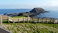
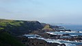
Located 1.5 hours drive south-east of Melbourne, PINP covers several separate areas over 1805 hectares. The parks include Pyramid Rock, Rhyll Inlet, Seal Rocks, and Cape Woolamai, with specific viewing and attraction areas that include the Nobbies Centre (seals, dolphins, and shark viewing), the Penguin Parade (little penguins coming ashore at dusk), Koala Conservation Centre, and the Churchill Island Heritage Farm.

Phillip Island’s Penguin Parade is the only commercial venue in the world where you can see penguins in their own environment and attracts tourists from different parts of the world. The Koala Conservation Centre is dedicated to koala research and conservation and allows the opportunity to view koalas in their natural habitat on treetop boardwalks.

Much of the park lies within the Phillip Island Important Bird Area, so identified by BirdLife International because of its importance in supporting significant populations of little penguins, short-tailed shearwaters and Pacific gulls. [2]

Related Research Articles

<span class="mw-page-title-main">Little penguin</span> Species of penguin

The little penguin is a species of penguin from New Zealand. They are commonly known as little blue penguins or blue penguins owing to their slate-blue plumage and are also known by their Māori name kororā, and their Boonwurrung name Djinan Yawa-dji Goyeep.

<span class="mw-page-title-main">Flinders Chase National Park</span> Protected area in South Australia

Flinders Chase National Park is a protected area in the Australian state of South Australia located at the west end of Kangaroo Island about 177 kilometres west-south west of the state capital of Adelaide and 110 kilometres west of the municipal seat of Kingscote. It is a sanctuary for endangered species and home to a few geological phenomena. It was the second national park to be declared in South Australia.

<span class="mw-page-title-main">Phillip Island</span> Island in Victoria, Australia

Phillip Island is an Australian island about 125 km (78 mi) south-southeast of Melbourne, Victoria. The island is named after Governor Arthur Phillip, the first Governor of New South Wales, by explorer and seaman George Bass, who sailed in a whaleboat, arriving from Sydney on 5 January 1798.

<span class="mw-page-title-main">Mornington Peninsula</span> Peninsula and region of Victoria, Australia

The Mornington Peninsula is a peninsula located south of Melbourne, Victoria, Australia. It is surrounded by Port Phillip to the west, Western Port to the east and Bass Strait to the south, and is connected to the mainland in the north. Geographically, the peninsula begins its protrusion from the mainland in the area between Pearcedale and an area north of Frankston. The area was originally home to the Mayone-bulluk and Boonwurrung-Balluk clans and formed part of the Boonwurrung nation's territory prior to European settlement.

<span class="mw-page-title-main">Bass Coast Shire</span> Local government area in Victoria, Australia

The Bass Coast Shire is a local government area in Victoria, Australia, located in the southeastern part of the state. It covers an area of 866 square kilometres (334 sq mi) and in June 2018 had a population of 35,327. It includes the towns of Bass, Cape Paterson, Cape Woolamai, Corinella, Coronet Bay, Cowes, Inverloch, Kilcunda, Lang Lang, Newhaven, Rhyll, San Remo, Summerlands and Wonthaggi as well as the historic locality of Krowera. It also includes the popular tourist destination Phillip Island. It was formed in 1994 from the amalgamation of the Shire of Bass, Shire of Phillip Island, Borough of Wonthaggi, parts of the Shire of Woorayl, Shire of Korumburra and City of Cranbourne.

<span class="mw-page-title-main">Western Port</span> Bay in Victoria, Australia

Western Port, commonly but unofficially known as Western Port Bay, is a large tidal bay in southern Victoria, Australia, opening into Bass Strait. It is the second largest bay in the state. Geographically, it is dominated by two large islands; French Island and Phillip Island. At the time it was renamed, its position was west of other known ports and bays, but Western Port has become something of a misnomer as it lies just to the east of the larger Port Phillip and the city of Melbourne. It is visited by Australian fur seals, whales and dolphins, as well as many migratory waders and seabirds. It is listed under the Ramsar Convention as a wetland of international significance.

<span class="mw-page-title-main">Penguin sweater</span>

Penguin sweaters, also known as penguin jumpers, are sweaters knitted for penguins that have been caught in oil slicks. When an oil spill affects penguins they have in the past been sometimes dressed in knitted sweaters, supposedly to stop them from poisoning themselves by ingesting the oil during preening, and to keep them warm, since the spilled oil destroys their natural oils. The sweaters are removed and discarded as soon as the penguins can be washed.

<span class="mw-page-title-main">Granite Island (South Australia)</span> Island in South Australia

Granite Island, also known by the Ramindjeri people as Nulcoowarra, is a small island next to Victor Harbor, South Australia, about 80 km south of South Australia's capital city, Adelaide.

<span class="mw-page-title-main">Penguin Island (Western Australia)</span> Island near Perth, Western Australia

Penguin Island is a 12.5-hectare (31-acre) island off the coast near Perth, approximately 660 metres (722 yd) from Shoalwater. It is home to a colony of approximately 150 little penguins, the largest population of the birds in Western Australia. Since 2007, the island had experienced an 80 percent decline in penguin numbers in 2019 from a peak of 1,700 that year.

<span class="mw-page-title-main">Cowes, Victoria</span> Town in Victoria, Australia

Cowes is the main township on Phillip Island in the Gippsland region of Victoria, Australia. It is about two hours' drive from Melbourne and can also be reached by coach, or passenger ferry from Stony Point on the Mornington Peninsula. Cowes is located on the northern side of Phillip Island and faces towards French Island and the Mornington Peninsula. At the 2021 census, Cowes had a population of 6,593.

Summerlands is a locality and a former residential subdivision on Phillip Island in Victoria, Australia, located in the south-west corner of the island, close to a little penguin breeding colony. In 1985, the Victorian government decided that, to protect the penguin rookery, further development of the subdivision would be prohibited and all the properties would be progressively purchased by the state.

SEA LIFE Sydney Aquarium is a public aquarium that features a large variety of Australian aquatic life, displaying more than 700 species comprising more than 13,000 individual fish and other sea and water creatures from most of Australia's water habitats. Opened in 1988, it is regarded as one of Sydney's premier tourist attractions with over 55% of its visitors each year coming from overseas.

<span class="mw-page-title-main">Nobbies Centre</span>

The Nobbies Centre is an ecotourism destination located at Point Grant, on the western tip of Phillip Island, Victoria, Australia. Once known as the Seal Rocks Sea Life Centre, the centre is managed by the Phillip Island Nature Park, and features educational displays, a cafe, a children's play area, and a gift shop. Overlooking Seal Rocks, Australia's largest colony of fur seals, with an estimated 16,000 inhabiting the area, around half a million people visit the centre yearly, with 53% being international visitors. A network of boardwalks outside the centre allow visitors to view the seal colony, The Nobbies, and The Blowhole.

<span class="mw-page-title-main">South Channel Fort</span> Island in southern Port Phillip, Victoria, Australia

South Channel Fort, also known as South Channel Island, is a 0.7 ha artificial island in southern Port Phillip, Victoria, Australia, 6 km north-east of the town of Sorrento. It was part of a network of fortifications protecting the narrow entrance to Port Phillip.

<span class="mw-page-title-main">Quail Island (Victoria)</span> Island in Victoria, Australia

Quail Island is the third-largest island in Australia's Western Port, after Phillip Island and French Island. The island was listed on the Register of the National Estate, and its wetlands are listed on the Ramsar Convention.

<span class="mw-page-title-main">Phillip Island Important Bird Area</span> Important Bird Area in Victoria, Australia

The Phillip Island Important Bird Area comprises a 20 km2 strip of coastline along the south and west coasts of Phillip Island, Victoria, in south-eastern Australia.

<i>Eudyptula novaehollandiae</i> Species of penguin

The Australian little penguin, also called the fairy penguin, is a species of penguin from Australia and the Otago region of New Zealand. The species was described as Spheniscusnovaehollandiae in 1826. It was later reclassified as Eudyptulaminornovaehollandiae, a subspecies of the little penguin. After a 2016 study, Eudyptula novaehollandiae was again recognized as a distinct species.

<span class="mw-page-title-main">Summerland Peninsula</span> Protected area in Victoria, Australia

The Summerland Peninsula is located at the western end of Phillip Island in Victoria, Australia. The peninsula lies within the Gippsland Plain Bioregion and is a site of high conservation significance.

References

  1. Hartman, Holly. "Penguin sweaters: Cozy tops give small birds a chance" . Retrieved 25 April 2008.
  2. "IBA: Phillip Island". Birdata. Birds Australia. Retrieved 17 September 2011.

38°29′S145°14′E / 38.483°S 145.233°E / -38.483; 145.233