Bass Strait is a sea strait separating Tasmania from the Australian mainland, specifically the state of Victoria. Formed 8,000 years ago by rising sea levels, the Bass Strait was named after explorer and physician George Bass.

King Island is an island in the Bass Strait, belonging to the Australian state of Tasmania. It is the largest of three islands known as the New Year Group, and the second-largest island in Bass Strait. The island's population at the 2016 census was 1,585 people, up from 1,566 in 2011. The local government area of the island is the King Island Council.

Flinders Island, the largest island in the Furneaux Group, is a 1,367-square-kilometre (528 sq mi) island in the Bass Strait, northeast of the island of Tasmania. Flinders Island is part of the state of Tasmania, Australia. It is 54 kilometres (34 mi) from Cape Portland and is located on 40° south, a zone known as the Roaring Forties.

The Furneaux Group is a group of approximately 100 islands located at the eastern end of Bass Strait, between Victoria and Tasmania, Australia. The islands were named after British navigator Tobias Furneaux, who sighted the eastern side of these islands after leaving Adventure Bay in 1773 on his way to New Zealand to rejoin Captain James Cook. Navigator Matthew Flinders was the first Westerner to explore the Furneaux Islands group in the Francis in 1798, and later that year in the Norfolk.

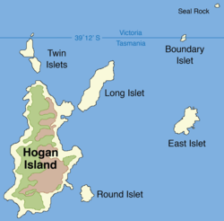
Boundary Islet, historically known as North East Islet, is a two ha (4.9-acre) islet in the Hogan Island Group of Bass Strait, at a latitude of 39°12′ S, about 56 km (35 mi) east of the southernmost point of mainland Victoria. The islet straddles the border of the Australian states of Victoria and Tasmania.
The Hunter Island, the main island of the Hunter Island Group, is a 7,330-hectare (18,100-acre) island, located in Bass Strait, that lies between King Island and north-west Tasmania, Australia.

Preservation Island is a low and undulating granite and calcarenite island, with an area of 207 ha, in south-eastern Australia. It is part of Tasmania’s Preservation Island Group, lying in eastern Bass Strait south-west of Cape Barren Island in the Furneaux Group, and is an important historic site.
The Albatross Island, part of the Hunter Island Group, is an 18-hectare (44-acre) island and nature reserve located in Bass Strait, that lies between north-west Tasmania and King Island, Australia. The Peerapper name for the island is Tangatema.

Deal Island, the largest island of the Kent Group, is a 1,576-hectare (3,890-acre) granite island, located in northern Bass Strait, that lies between the Furneaux Group, north-east of Tasmania and Wilsons Promontory in Victoria, Australia.
Hogan Island, the largest island of the Hogan Group, is a 232-hectare (570-acre) granite island, located in northern Bass Strait, that lies between the Furneaux Group in north-east Tasmania, and Wilsons Promontory in Victoria, Australia. The island has a maximum elevation of 116 metres (381 ft) AHD .
The Long Islet, part of the Hogan Group, is a 22.85-hectare (56.5-acre) unpopulated long, narrow granite island, located in northern Bass Strait, lying north of the Furneaux Group in Tasmania and south of Wilsons Promontory in Victoria, in south-eastern Australia.

The Passage Island, part of the Passage Group within the Furneaux Group, is a 253-hectare (630-acre) granite and dolerite island, located in Bass Strait south of Cape Barren Island, in Tasmania, in south-eastern Australia.
Badger Island, part of the Badger Group within the Furneaux Group, is a 1,242-hectare (3,070-acre) unpopulated low-lying granite and limestone island, located in Bass Strait, lying west of the Flinders and Cape Barren islands, Tasmania, south of Victoria, in south-eastern Australia.

Prime Seal Island is a long island, with a high central ridge and an area of 1220 ha, in south-eastern Australia. It is part of Tasmania’s Prime Seal Island Group, lying in eastern Bass Strait west of Flinders in the Furneaux Group. Geologically, it is limestone overlying granite and has notable karst features, including caves. It is leased for farming and is extensively grazed by sheep and cattle as well as the native Tasmanian pademelons.
The Low Islets are two small, flat, adjacent, granite islands, with a combined area of about 2 ha, in south-eastern Australia. They are part of Tasmania’s Prime Seal Island Group, lying in eastern Bass Strait west of Flinders in the Furneaux Group. The larger of the two islets has been used for grazing sheep, cattle and horses.
The Tenth Island, sometimes called Barrenjoey, part of the Waterhouse Island Group, is a 900-square-metre (9,700 sq ft) uninhabited granite islet and nature reserve, situated in Bass Strait, lying close to the north-eastern coast of Tasmania, Australia. The islet has no vegetation and much of it is wave-washed in winter storms. The Aboriginal name for the island is recorded as Roobala mangana.
The George Rocks, also historically known as King George's Rocks, is part of the Waterhouse Island Group, a group of three adjacent uninhabited granite islets and associated reefs with a combined area of 7 hectares, situated in Banks Strait, part of Bass Strait, lying close to the north-eastern coast of Tasmania, Australia.
Beagle Commonwealth Marine Reserve is a 2,928 km2 marine protected area within Australian waters located in Bass Strait off the coast of Victoria and near Tasmania's Flinders Island. The reserve was established in 2007 and is part of the South-east Commonwealth Marine Reserve Network.