
The Tasman Sea is a marginal sea of the South Pacific Ocean, situated between Australia and New Zealand. It measures about 2,000 km (1,200 mi) across and about 2,800 km (1,700 mi) from north to south. The sea was named after the Dutch explorer Abel Janszoon Tasman, who in 1642 was the first known person to cross it. British explorer Lieutenant James Cook later extensively navigated the Tasman Sea in the 1770s during his three voyages of exploration.

The Tasman National Park is a national park in eastern Tasmania, Australia, approximately 56 kilometres (35 mi) east of Hobart. The 107.5-square-kilometre (41.5 sq mi) park is situated on part of both the Forestier and Tasman peninsulas and encompasses all of Tasman Island.
The Tasman Peninsula, officially Turrakana / Tasman Peninsula, is a peninsula located in south-east Tasmania, Australia, approximately 75 km (47 mi) by the Arthur Highway, south-east of Hobart.
The Storm Bay is a large bay in the south-east region of Tasmania, Australia.
The Maatsuyker Islands are a group of islands and rocks located 5.5 kilometres (3.4 mi) off the south coast of Tasmania, Australia. Maatsuyker Island is the southernmost island of the group and of the Australian continental shelf. There are exposed rocks further south of Maatsuyker but they do not meet the definition of "islands". Macquarie Island, far to the south, is also Australian territory but it is an upthrust piece of ocean floor in the remote Southern Ocean and is in a geological sense completely separate from the continent.

De Witt Island, also known as Big Witch, is an island located close to the south-western coast of Tasmania, Australia. The 516-hectare (1.99 sq mi) island is the largest of the Maatsuyker Islands Group, and comprises part of the Southwest National Park and the Tasmanian Wilderness World Heritage Site. The island is listed on the Australian Register of the National Estate.

Eddystone is a tower-shaped rock or small island, located in the Southern Ocean, off the southern coast of Tasmania, Australia. The island is situated approximately 27 km (17 mi) from the South East Cape on a bearing of 149° and is contained within the Southwest National Park, part of the Tasmanian Wilderness World Heritage Site. An erosional remnant of the Tasmanian mainland with an elevation of 30 m (98 ft) above sea level, the island is estimated to have separated from the Tasmanian mainland at least 15,000 years ago.

Mewstone is an unpopulated island, composed of muscovite granite, located close to the south coast of Tasmania, Australia. The 13.1-hectare (32-acre) island has steep cliffs and a small flat summit and is part of the Pedra Branca group, lying 12 kilometres (7.5 mi) southeast of Maatsuyker Island, and 22 kilometres (14 mi) off the south coast of Tasmania. Mewstone comprises part of the Southwest National Park and the Tasmanian Wilderness World Heritage Site.

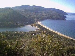
The Freycinet Peninsula is a large peninsula located on the eastern coast of Tasmania, Australia. The peninsula is located north of Schouten Island and is contained within the Freycinet National Park.
Eaglehawk Neck, officially Teralina / Eaglehawk Neck, is a narrow isthmus that connects the Tasman Peninsula with the Forestier Peninsula, and hence to mainland Tasmania, Australia.

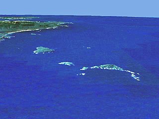
The St Helens Island, part of the Waterhouse Island Group, is a 51-hectare (130-acre) granite island situated in the Tasman Sea, lying close to the north-eastern coast of Tasmania, Australia.
The Paddys Island, part of the Waterhouse Island Group, is a 4.6-hectare (11-acre) uninhabited granite island situated in the Tasman Sea, lying close to the north-eastern coast of Tasmania, Australia.
The Lanterns, part of the Tasman Island Group, are three small and very steep islands with a combined area of 5.35 hectares, lying close to the south-eastern coast of Tasmania, Australia. The island is located in the Tasman Sea, situated off the Tasman Peninsula and is contained within the Tasman National Park.

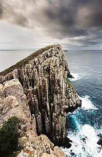
The Tasman Island, part of the Tasman Island Group, is an oval island with an area of 1.2 square kilometres (0.46 sq mi), lying close to the south-eastern coast of Tasmania, Australia. The island is located in the Tasman Sea, situated off the Tasman Peninsula and is contained within the Tasman National Park.

The Tasman Island Lighthouse is on Tasman Island off the coast of southeastern Tasmania, Australia. It was one of the most isolated lighthouses in Australia. It was first lit on 2 April 1906, automated in 1976 and demanned in 1977. Solar conversion occurred in 1991. Various light sources have been fitted to the lighthouse since low voltage solar was installed in 1991. The current light source is a Vega VRB25. It has a character of Flashing 7.5x - Flash 0.1s - Eclipse 7.4s and produces 63,000 candelas with a geographical range of 39 nautical miles and a nominal range of 18 nautical miles.
The Wedge Island, part of the Tasman Island Group, is an island with an area of 43 hectares lying close to the south-eastern coast of Tasmania, Australia. The island is located in Storm Bay, situated off the Tasman Peninsula.
Hog Island is a small island and nature reserve, with an area of 0.35 hectares, part of the Sloping Island Group, lying in the Frederick Henry Bay, close to the south-eastern coast of Tasmania, Australia. The island is situated around the Tasman and Forestier Peninsulas.
Woody Island is an island in south-eastern Australia. It is part of the Sloping Island Group, lying close to the south-eastern coast of Tasmania around the Tasman and Forestier Peninsulas.
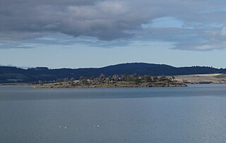
The Norfolk Bay is a body of water in the south east of Tasmania, Australia. The north west aspect of Norfolk Bay is continuous with Frederick Henry Bay. The north east aspect of Norfolk Bay is continuous with Blackman Bay via the Denison Canal.
The Tasman Island Group is a group of islands near the Tasman Peninsula in south-east Tasmania, Australia.
