
Cape Barren Island, officially truwana / Cape Barren Island, is a 478-square-kilometre (185 sq mi) island in Bass Strait, off the north-east coast of Tasmania, Australia. It is the second-largest island of the Furneaux Group, with the larger Flinders Island to the north, and the smaller Clarke Island to the south. The highest point on the island is Mount Munro at 715 metres (2,346 ft). Mount Munro is named after James Munro, a former convict turned sealer who, from the 1820s, lived for more than 20 years with various indigenous women on nearby Preservation Island.

Waterhouse Island, part of the Waterhouse Island Group, is a 287-hectare (710-acre) granite island situated in Banks Strait, part of Bass Strait, lying close to the north-eastern coast of Tasmania, Australia.
The Goose Island, part of the Badger Group within the Furneaux Group, is a 109-hectare (270-acre) unpopulated elongated granite island, located in Bass Strait, lying west of the Flinders and Cape Barren islands, Tasmania, south of Victoria, in south-eastern Australia.

The Judgement Rocks, part of the Kent Group, is a small unpopulated 0.39-hectare (0.96-acre) granite islet and some associated bare rocks, located in the Bass Strait, lying off the north-east coast of Tasmania, between the Furneaux Group and Wilsons Promontory in Victoria, Australia. The islet and associated rocks are contained within the Kent Group National Park.
The Bass Pyramid, part of the Furneaux Group, is a small, two sectioned oval, steep-sided 100-square-metre (1,100 sq ft) unpopulated granite island, located in Bass Strait, lying north of the Flinders Island and south of the Kent Group, in Tasmania, Australia. A rock bridge connects the two sections.

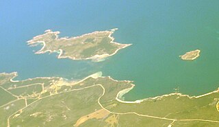
The Passage Island, part of the Passage Group within the Furneaux Group, is a 253-hectare (630-acre) granite and dolerite island, located in Bass Strait south of Cape Barren Island, in Tasmania, in south-eastern Australia.
The Forsyth Island, part of the Passage Group within the Furneaux Group, is a 167-hectare (410-acre) granite island, located in Bass Strait south of Cape Barren Island, in Tasmania, in south-eastern Australia. With the Passage and Gull islands, the Forsyth Island forms part of the Forsyth, Passage and Gull Islands Important Bird Area (IBA), identified as such by BirdLife International because it supports over 1% of the world populations of little penguins and black-faced cormorants.

The Low Islets, part of the Passage Group within the Furneaux Group, is a close pair of unpopulated small granite islands with a combined area of 2 hectares, located in Bass Strait, south of Cape Barren Island, and west of both Spike and Clarke islands, in Tasmania, in south-eastern Australia.
The Spike Island, part of the Passage Group within the Furneaux Group, is a close pair of unpopulated granite islands with a combined area of 6 hectares, located in Bass Strait, south of Cape Barren Island in Spike Bay just off the west coast of Clarke Island, in Tasmania, in south-eastern Australia.
The Battery Island, part of the Passage Group within the Furneaux Group, is a 2-hectare (4.9-acre) granite island, located in Bass Strait south of Cape Barren Island, in Tasmania, in south-eastern Australia.
The Little Badger Island, part of the Badger Group within the Furneaux Group, is a 2.5-hectare (6.2-acre) unpopulated low-lying granite island, located in Bass Strait, lying west of the Flinders and Cape Barren islands, Tasmania, south of Victoria, in south-eastern Australia.
The North West Mount Chappell Islet, part of the Badger Group within the Furneaux Group, is a 7,100-square-metre (76,000 sq ft) unpopulated mainly granite islet, in Bass Strait, lying west of the Flinders and Cape Barren islands, Tasmania, south of Victoria, in south-eastern Australia. The island is located within a conservation area and is part of the Chalky, Big Green and Badger Island Groups Important Bird Area.
The Inner Little Goose Island, part of the Badger Group within the Furneaux Group, is a 4.5-hectare (11-acre) unpopulated small, round granite island, located in Bass Strait between Goose and Little Goose islands, lying west of the Flinders and Cape Barren islands, Tasmania, south of Victoria, in south-eastern Australia. The island is contained within a conservation area and is part of the Chalky, Big Green and Badger Island Groups Important Bird Area.
The Little Goose Island, part of the Badger Group within the Furneaux Group, is a 3.6-hectare (8.9-acre) unpopulated flat, round granite island, located in Bass Strait, lying west of the Flinders and Cape Barren islands, Tasmania, south of Victoria, in south-eastern Australia. The island is contained within a nature reserve and is part of the Chalky, Big Green and Badger Island Groups Important Bird Area.
The Beagle Island, part of the Badger Group within the Furneaux Group, is a 1.2-hectare (3.0-acre) unpopulated low, flat granite island, located in Bass Strait, lying west of the Flinders and Cape Barren islands, Tasmania, south of Victoria, in south-eastern Australia. The island is contained within a nature reserve and is part of the Chalky, Big Green and Badger Island Groups Important Bird Area.
The Doughboy Island, part of the Tin Kettle Group within the Furneaux Group, is a 30-hectare (74-acre) unpopulated mainly granite island, located in Bass Strait, lying west of the Flinders and Cape Barren islands, Tasmania, in south-eastern Australia.
The Great Dog Island, also known as Big Dog Island, and part of the Great Dog Group within the Furneaux Group, is a 354-hectare (870-acre) granite island, located in Bass Strait, lying south of the Flinders Island and north of the Cape Barren Island, in Tasmania, in south-eastern Australia.

The Storehouse Island, part of the Babel Group within the Furneaux Group, is a 20-hectare (49-acre) unpopulated granite island, located in Bass Strait, lying off the east coast of Flinders Island, Tasmania, south of Victoria, in south-eastern Australia.
The George Rocks, also historically known as King George's Rocks, is part of the Waterhouse Island Group, a group of three adjacent uninhabited granite islets and associated reefs with a combined area of 7 hectares, situated in Banks Strait, part of Bass Strait, lying close to the north-eastern coast of Tasmania, Australia.

