
Waterhouse Island, part of the Waterhouse Island Group, is a 287-hectare (710-acre) granite island situated in Banks Strait, part of Bass Strait, lying close to the north-eastern coast of Tasmania, Australia.

The Bird Rock, part of the Waterhouse Island Group, is an uninhabited 1-hectare (2.5-acre) granite islet situated in Banks Strait, part of Bass Strait, lying close to the north-eastern coast of Tasmania, Australia.
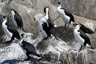
The Albatross Island, part of the Hunter Island Group, is an 18-hectare (44-acre) island and nature reserve located in Bass Strait, that lies between north-west Tasmania and King Island, Australia. The Peerapper name for the island is Tangatema.

The Judgement Rocks, part of the Kent Group, is a small unpopulated 0.39-hectare (0.96-acre) granite islet and some associated bare rocks, located in the Bass Strait, lying off the north-east coast of Tasmania, between the Furneaux Group and Wilsons Promontory in Victoria, Australia. The islet and associated rocks are contained within the Kent Group National Park.

Hogan Island, the largest island of the Hogan Group, is a 232-hectare (570-acre) granite island, located in northern Bass Strait, that lies between the Furneaux Group in north-east Tasmania, and Wilsons Promontory in Victoria, Australia. The island has a maximum elevation of 116 metres (381 ft) AHD .

The Forsyth Island, part of the Passage Group within the Furneaux Group, is a 167-hectare (410-acre) granite island, located in Bass Strait south of Cape Barren Island, in Tasmania, in south-eastern Australia. With the Passage and Gull islands, the Forsyth Island forms part of the Forsyth, Passage and Gull Islands Important Bird Area (IBA), identified as such by BirdLife International because it supports over 1% of the world populations of little penguins and black-faced cormorants.

The Low Islets, part of the Passage Group within the Furneaux Group, is a close pair of unpopulated small granite islands with a combined area of 2 hectares, located in Bass Strait, south of Cape Barren Island, and west of both Spike and Clarke islands, in Tasmania, in south-eastern Australia.
The Moriarty Rocks, part of the Passage Group within the Furneaux Group, are a group of two major unpopulated granite rocks, and several smaller ones, with a combined area of 2.46 hectares, located in Bass Strait, south of Cape Barren Island, west of the Low Islets, and west of the Spike and Clarke islands, in Tasmania, in south-eastern Australia. The rocks are contained within a nature reserve.
The North West Mount Chappell Islet, part of the Badger Group within the Furneaux Group, is a 7,100-square-metre (76,000 sq ft) unpopulated mainly granite islet, in Bass Strait, lying west of the Flinders and Cape Barren islands, Tasmania, south of Victoria, in south-eastern Australia. The island is located within a conservation area and is part of the Chalky, Big Green and Badger Island Groups Important Bird Area.
The Ninth Island, part of the Waterhouse Island Group, is a 32-hectare (79-acre) uninhabited granite island situated in Bass Strait, lying close to the north-eastern coast of Tasmania, Australia. In November 2018, it was listed for sale for the fourth time, at $1.98 million. The property for sale is a landlocked title within a conservation covenant, preventing access to the island by any means except helicopter.
The Little Waterhouse Island, part of the Waterhouse Island Group, is a 2.5-hectare (6.2-acre) granite island situated in Banks Strait, part of Bass Strait, lying close to the north-eastern coast of Tasmania, Australia.
The Maclean Island, part of the Waterhouse Island Group, is a 1.11-hectare (2.7-acre) uninhabited granite islet, situated in Banks Strait, part of Bass Strait, lying close to the north-eastern coast of Tasmania, Australia.
The Baynes Island, part of the Waterhouse Island Group, are a group of three granite uninhabited islets connected at low tide, with a combined area of 1.62 hectares, situated in Banks Strait, part of Bass Strait, lying close to the north-eastern coast of Tasmania, Australia.

The Cygnet Island, part of the Waterhouse Island Group, is a 0.5-hectare (1.2-acre) granite islet situated in Banks Strait, part of Bass Strait, lying close to the north-eastern coast of Tasmania, Australia.

The Foster Islands, part of the Waterhouse Island Group, are two small granite islands with a combined area of 48 hectares situated in Banks Strait, part of Bass Strait, lying close to the north-eastern coast of Tasmania, Australia. The islands form part of Small Bass Strait Island nature reserve.
The Little Swan Island, part of the Waterhouse Island Group, is a 12.64-hectare (31.2-acre) uninhabited granite island situated in Banks Strait, part of Bass Strait, lying close to the north-eastern coast of Tasmania, Australia.

Swan Island, part of the Waterhouse Island Group, is a 239-hectare (590-acre) granite island situated in Banks Strait, part of Bass Strait, lying close to the north-eastern coast of Tasmania, Australia.
The George Rocks, also historically known as King George's Rocks, is part of the Waterhouse Island Group, a group of three adjacent uninhabited granite islets and associated reefs with a combined area of 7 hectares, situated in Banks Strait, part of Bass Strait, lying close to the north-eastern coast of Tasmania, Australia.
The St Helens Island, part of the Waterhouse Island Group, is a 51-hectare (130-acre) granite island situated in the Tasman Sea, lying close to the north-eastern coast of Tasmania, Australia.
The Paddys Island, part of the Waterhouse Island Group, is a 4.6-hectare (11-acre) uninhabited granite island situated in the Tasman Sea, lying close to the north-eastern coast of Tasmania, Australia.

