
Rodondo Island is a granite island, part of the Rodondo Group, lying in northern Bass Strait, within the state boundaries of Tasmania, Australia. The island is located only 10 kilometres (6.2 mi) south of Wilsons Promontory in Victoria, and 2' of latitude south of the Victoria-Tasmania border at latitude 39°12'S. Rodondo Island is ringed by steep cliffs up to 200 metres (660 ft) high, with an area of 106 hectares and a maximum elevation of 350 metres (1,150 ft) above sea level.

The New Year Island, part of the New Year Group, is a 98.22-hectare (242.7-acre) granite island and game reserve located in the Great Australian Bight, lying off the north-west coast of Tasmania, Australia. While much smaller in area than the adjacent King Island, the New Year Island lends its name to the island group due to its European discovery a few days earlier than the King Island.

The Judgement Rocks, part of the Kent Group, is a small unpopulated 0.39-hectare (0.96-acre) granite islet and some associated bare rocks, located in the Bass Strait, lying off the north-east coast of Tasmania, between the Furneaux Group and Wilsons Promontory in Victoria, Australia. The islet and associated rocks are contained within the Kent Group National Park.
Erith Island, the second largest island in the Kent Group, is a densely vegetated and unpopulated 323-hectare (800-acre) granite island with steep slopes, located in the Bass Strait, lying off the north-east coast of Tasmania, between the Furneaux Group and Wilsons Promontory in Victoria, Australia.
The South West Isle, part of the Kent Group, is an unpopulated 19.09-hectare (47.2-acre) granite island, located in the Bass Strait, lying off the north-east coast of Tasmania, between the Furneaux Group and Wilsons Promontory in Victoria, Australia.

The Long Islet, part of the Hogan Group, is a 22.85-hectare (56.5-acre) unpopulated long, narrow granite island, located in northern Bass Strait, lying north of the Furneaux Group in Tasmania and south of Wilsons Promontory in Victoria, in south-eastern Australia.
Round Island is a granite island, with an area of 3.95 ha, in south-eastern Australia. It is part of Tasmania’s Hogan Group, lying in northern Bass Strait between the Furneaux Group and Wilsons Promontory in Victoria.
East Island is a granite island, with an area of 12.42 ha, in south-eastern Australia. It is part of Tasmania’s Hogan Group, lying in northern Bass Strait between the Furneaux Group and Wilsons Promontory in Victoria.

Curtis Island is a granite island, with an area of 150 ha, in south-eastern Australia. It is part of Tasmania’s Curtis Group, lying in northern Bass Strait between the Furneaux Group and Wilsons Promontory in Victoria. It is a nature reserve and has been identified as an Important Bird Area because it supports up to 390,000 breeding pairs of short-tailed shearwaters or Tasmanian muttonbirds.
Cone Islet is a small granite island, with an area of 4.82 ha, in south-eastern Australia. It is part of Tasmania’s Curtis Group, lying in northern Bass Strait between the Furneaux Group and Wilsons Promontory in Victoria.

Devils Tower comprises two small and rugged granite islands, with a combined area of 4.77 hectares, in south-eastern Australia. It is part of Tasmania’s Curtis Group, lying in northern Bass Strait between the Furneaux Group and Wilsons Promontory in Victoria. It is a nature reserve.
West Moncoeur Island is a granite island, ringed by steep cliffs, with an area of 9.18 ha, in south-eastern Australia. It is part of Tasmania’s Rodondo Group, lying in northern Bass Strait south of Wilsons Promontory in Victoria. It is a nature reserve.

The Passage Island, part of the Passage Group within the Furneaux Group, is a 253-hectare (630-acre) granite and dolerite island, located in Bass Strait south of Cape Barren Island, in Tasmania, in south-eastern Australia.
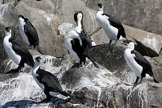
Boxen Island is a flat dolerite island, with an area of 7 ha, in south-eastern Australia. It is part of Tasmania’s Long Island Group, lying in eastern Bass Strait west of Cape Barren Island in the Furneaux Group. Together with nearby Big Black Reef it is classified by BirdLife International as an Important Bird Area because it has been recorded as supporting 288 breeding pairs of black-faced cormorants.
The East Kangaroo Island, part of the Big Green Group within the Furneaux Group, is a 157-hectare (390-acre) unpopulated limestone island with granite outcrops and dolerite dykes, located in the Bass Strait, west of the Flinders Island, in Tasmania, in south-eastern Australia.

The Chalky Island, part of the Big Green Group within the Furneaux Group, is a 41-hectare (100-acre) unpopulated granite island with limestone outcrops and dolerite dykes, located in the Bass Strait, west of the Flinders Island, in Tasmania, in south-eastern Australia. The island is contained within a conservation area and is part of the Chalky, Big Green and Badger Island Groups Important Bird Area.
The Isabella Island, part of the Big Green Group within the Furneaux Group, is a 11.4-hectare (28-acre) unpopulated granite island, located in the Bass Strait, west of the Flinders Island and south of Chalky Island, in Tasmania, in south-eastern Australia. The island is a nature reserve and is part of the Chalky, Big Green and Badger Island Groups Important Bird Area.

The Ile du Golfe is a limestone island located close to the south-western coast of Tasmania, Australia. The long, narrow dolphin-shaped 68-hectare (0.26 sq mi) island is part of the Maatsuyker Islands Group, and comprises part of the Southwest National Park and the Tasmanian Wilderness World Heritage Site.

Round Top Island is an island located close to the south-western coast of Tasmania, Australia. The 6.25-hectare (0.0241 sq mi) island is part of the Maatsuyker Islands Group, and comprises part of the Southwest National Park and the Tasmanian Wilderness World Heritage Site.
Great Glennie Island is a small, rugged, granite island in the Glennie group of islands off the west coast of Wilsons Promontory, Victoria, Australia. It is part of the Wilsons Promontory Islands Important Bird Area, identified as such by BirdLife International because of its importance for breeding seabirds.
