
Little Green Island is a granite island, with an area of 87 hectares, in south-eastern Australia. It is part of Tasmania’s Great Dog Island Group, lying in eastern Bass Strait between Flinders and Cape Barren Islands in the Furneaux Group. It is partly a conservation area, and partly private property, used for grazing livestock. The island has been degraded by repeated burning and grazing. Commercial muttonbirding took place until 1957, and recreational muttonbirding since then. The island is part of the Franklin Sound Islands Important Bird Area, identified as such by BirdLife International because it holds over 1% of the world populations of six bird species.
The Goose Island, part of the Badger Group within the Furneaux Group, is a 109-hectare (270-acre) unpopulated elongated granite island, located in Bass Strait, lying west of the Flinders and Cape Barren islands, Tasmania, south of Victoria, in south-eastern Australia.
The Oyster Rocks are a close pair of small granite islands, with a combined area of about 6 ha, in south-eastern Australia. They are part of Tasmania’s Tin Kettle Island Group, lying in eastern Bass Strait between Flinders and Cape Barren Islands in the Furneaux Group. They are a conservation area. The islands are part of the Franklin Sound Islands Important Bird Area, identified as such by BirdLife International because it holds over 1% of the world populations of six bird species.

The South West Isle, part of the Kent Group, is an unpopulated 19.09-hectare (47.2-acre) granite island, located in the Bass Strait, lying off the north-east coast of Tasmania, between the Furneaux Group and Wilsons Promontory in Victoria, Australia.

The Passage Island, part of the Passage Group within the Furneaux Group, is a 253-hectare (630-acre) granite and dolerite island, located in Bass Strait south of Cape Barren Island, in Tasmania, in south-eastern Australia.

The Big Black Reef, part of the Long Island Group within the Furneaux Group, is a 0.54-hectare (1.3-acre) unpopulated small, flat dolerite island, located in Bass Strait, lying west of Cape Barren Island, Tasmania, in south-eastern Australia.
Badger Island, part of the Badger Group within the Furneaux Group, is a 1,242-hectare (3,070-acre) unpopulated low-lying granite and limestone island, located in Bass Strait, lying west of the Flinders and Cape Barren islands, Tasmania, south of Victoria, in south-eastern Australia.
The Little Goose Island, part of the Badger Group within the Furneaux Group, is a 3.6-hectare (8.9-acre) unpopulated flat, round granite island, located in Bass Strait, lying west of the Flinders and Cape Barren islands, Tasmania, south of Victoria, in south-eastern Australia. The island is contained within a nature reserve and is part of the Chalky, Big Green and Badger Island Groups Important Bird Area.
The Anderson Island, also known as Woody Island, part of the Tin Kettle Island Group of the Furneaux Group, is a 166-hectare (410-acre) granite island, located in Bass Strait, lying northeast of Tasmania, in south-eastern Australia. Anderson Island lies between Flinders and Cape Barren Islands and is partly a pastoral lease used for grazing sheep and cattle. The island is joined at low tide to nearby Little Anderson and Tin Kettle Islands by extensive intertidal mudflats. The island is supposed to be named after John Anderson, a sealer living on the island by 1842.
Little Anderson Island is an island, with an area of 13 ha, in south-eastern Australia. It is part of Tasmania’s Tin Kettle Island Group, lying in eastern Bass Strait between Flinders and Cape Barren Islands in the Furneaux Group. The island is joined at low tide to nearby Anderson and Tin Kettle Islands by extensive intertidal mudflats. The island is part of the Franklin Sound Islands Important Bird Area, identified as such by BirdLife International because it holds over 1% of the world populations of six bird species.

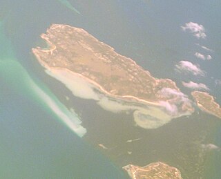
Tin Kettle Island is a long, sandy island, with an area of 176 ha, in south-eastern Australia. It is part of Tasmania’s Tin Kettle Island Group, lying in eastern Bass Strait between Flinders and Cape Barren Islands in the Furneaux Group. The island is joined at low tide to nearby Anderson and Little Andersons by extensive intertidal mudflats. The island is farmed, mainly cattle grazing. The island is part of the Franklin Sound Islands Important Bird Area, identified as such by BirdLife International because it holds over 1% of the world populations of six bird species.
The Doughboy Island, part of the Tin Kettle Group within the Furneaux Group, is a 30-hectare (74-acre) unpopulated mainly granite island, located in Bass Strait, lying west of the Flinders and Cape Barren islands, Tasmania, in south-eastern Australia.
Little Dog Island is a square, flat granite island, with an area of 83 ha, in south-eastern Australia. It is part of Tasmania’s Great Dog Island Group, lying in eastern Bass Strait between Flinders and Cape Barren Islands in the Furneaux Group. It is a game reserve. It was previously grazed, a usage now ceased. The island is part of the Franklin Sound Islands Important Bird Area, identified as such by BirdLife International because it holds over 1% of the world populations of six bird species.

The Great Dog Island, also known as Big Dog Island, and part of the Great Dog Group within the Furneaux Group, is a 354-hectare (870-acre) granite island, located in Bass Strait, lying south of the Flinders Island and north of the Cape Barren Island, in Tasmania, in south-eastern Australia.

Vansittart Island, also known as Gun Carriage Island, is a granite island with an area of 800 hectares. The island is part of Tasmania's Vansittart Island Group, lying in eastern Bass Strait between Flinders and Cape Barren Islands in the Furneaux Group.

Pelican Island is an island, with an area of 6.8 ha including an associated reef joined to it at low tide, in south-eastern Australia. It is part of Tasmania’s Vansittart Island Group, lying in eastern Bass Strait between Flinders and Cape Barren Islands in the Furneaux Group. Until 1984 it was leased for grazing. The island is part of the Franklin Sound Islands Important Bird Area, identified as such by BirdLife International because it holds over 1% of the world populations of six bird species.
The East Kangaroo Island, part of the Big Green Group within the Furneaux Group, is a 157-hectare (390-acre) unpopulated limestone island with granite outcrops and dolerite dykes, located in the Bass Strait, west of the Flinders Island, in Tasmania, in south-eastern Australia.
The Big Green Island, part of the Big Green Group within the Furneaux Group, is a 122-hectare (300-acre) granite island with limestone and dolerite outcrops, located in Bass Strait west of Flinders Island, in Tasmania, in south-eastern Australia. The island is partly contained within a nature reserve with the rest being used for farming; and is part of the Chalky, Big Green and Badger Island Groups Important Bird Area.
The Little Chalky Island, part of the Big Green Group within the Furneaux Group, is a 5-hectare (12-acre) unpopulated granite island, located in the Bass Strait, west of the Flinders Island and south of Chalky Island, in Tasmania, in south-eastern Australia. The island is part of the Chalky, Big Green and Badger Island Groups Important Bird Area.
The Isabella Island, part of the Big Green Group within the Furneaux Group, is a 11.4-hectare (28-acre) unpopulated granite island, located in the Bass Strait, west of the Flinders Island and south of Chalky Island, in Tasmania, in south-eastern Australia. The island is a nature reserve and is part of the Chalky, Big Green and Badger Island Groups Important Bird Area.

