Lachlan Island

Last updated

Lachlan Island
Relief Map of Tasmania.png
Red pog.svg
Lachlan Island
Location in Tasmania
Geography
LocationEast Coast Tasmania
Coordinates 42°38′24″S147°58′12″E / 42.64000°S 147.97000°E / -42.64000; 147.97000 Coordinates: 42°38′24″S147°58′12″E / 42.64000°S 147.97000°E / -42.64000; 147.97000
ArchipelagoMaria Island Group
Adjacent bodies of waterMercury Passage
Area2.5 ha (6.2 acres)
Administration
Australia
State Tasmania
Additional information
Time zone
  Summer (DST)

The Lachlan Island, part of the Maria Island Group, is an island with an area of about 2.5 hectares (6 acres) lying close to the south-eastern coast of Tasmania, Australia. The island is located near the Freycinet Peninsula, situated midway between Maria Island and the Tasmanian mainland. [1]

Island Any piece of sub-continental land that is surrounded by water

An island or isle is any piece of sub-continental land that is surrounded by water. Very small islands such as emergent land features on atolls can be called islets, skerries, cays or keys. An island in a river or a lake island may be called an eyot or ait, and a small island off the coast may be called a holm. A grouping of geographically or geologically related islands, such as the Philippines, is referred to as an archipelago.

Tasmania island state of Australia

Tasmania is an island state of Australia. It is located 240 km (150 mi) to the south of the Australian mainland, separated by Bass Strait. The state encompasses the main island of Tasmania, the 26th-largest island in the world, and the surrounding 334 islands. The state has a population of around 533,308 as of March 2019. Just over forty percent of the population resides in the Greater Hobart precinct, which forms the metropolitan area of the state capital and largest city, Hobart.

Australia Country in Oceania

Australia, officially the Commonwealth of Australia, is a sovereign state comprising the mainland of the Australian continent, the island of Tasmania, and numerous smaller islands. It is the largest country in Oceania and the world's sixth-largest country by total area. The neighbouring countries are Papua New Guinea, Indonesia, and East Timor to the north; the Solomon Islands and Vanuatu to the north-east; and New Zealand to the south-east. The population of 26 million is highly urbanised and heavily concentrated on the eastern seaboard. Australia's capital is Canberra, and its largest city is Sydney. The country's other major metropolitan areas are Melbourne, Brisbane, Perth, and Adelaide.

Contents

Fauna

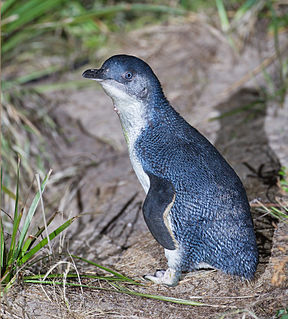
Recorded breeding seabird and wader species are little penguin, short-tailed shearwater, kelp gull, sooty oystercatcher and Caspian tern. Rabbits were introduced in the early 20th century and were eventually eradicated in the 1990s. [1]

Seabird Birds that have adapted to life within the marine environment

Seabirds are birds that are adapted to life within the marine environment. While seabirds vary greatly in lifestyle, behaviour and physiology, they often exhibit striking convergent evolution, as the same environmental problems and feeding niches have resulted in similar adaptations. The first seabirds evolved in the Cretaceous period, and modern seabird families emerged in the Paleogene.

Wader

Waders are birds commonly found along shorelines and mudflats that wade in order to forage for food in the mud or sand. They are called shorebirds in North America, where the term "wader" is used to refer to long-legged wading birds such as storks and herons. Waders are members of the order Charadriiformes, which includes gulls, auks and their allies.

Little penguin smallest penguin species

The little penguin is the smallest species of penguin. It grows to an average of 33 cm (13 in) in height and 43 cm (17 in) in length, though specific measurements vary by subspecies. It is found on the coastlines of southern Australia and New Zealand, with possible records from Chile. In Australia, they are often called fairy penguins because of their small size. In New Zealand, they are more commonly known as little blue penguins or blue penguins owing to their slate-blue plumage; they are also known by their Māori name: kororā.

See also

Tasmania's offshore islands: seabirds and other natural features is a book published by the Tasmanian Museum and Art Gallery in 2001. The book is considered an essential measure of the state of Tasmania's islands, birds inhabiting them, and the condition of the islands. The main author was Nigel Brothers, a Hobart based biologist, the other contributors were Vanessa Halley, Helen Pryor, and David Pemberton.

The Tasmanian archipelago is made up of 334 islands. This book highlights the uniqueness and importance of 280, as significant breeding refuges and wealthy natural resources. Islands are documented with descriptions of topography, wildlife, vegetation and full-colour photographs."

Related Research Articles

Breaksea Islands (Tasmania)

The Breaksea Islands Group is a group of six islands, located in the Southern Ocean, off the south western coast of Tasmania, Australia.

Kathleen Island island in Australia

Kathleen Island is a steeply cliffed island that lies within Port Davey, an oceanic inlet, located in the south west region of Tasmania, Australia. The island has an area of approximately 11.35 hectares and is contained with the Southwest National Park, part of the Tasmanian Wilderness World Heritage Site and the Port Davey/Bathurst Harbour Marine Nature Reserve.

Shanks Islands

The Shanks Islands form a group of five small rocky islets located close to the south-western coast of Tasmania, Australia. Situated near where the mouth of Port Davey meets the Southern Ocean, the islets have a combined area of 2.72 hectares and are part of the Swainson Islands Group. They comprise part of the Southwest National Park and the Tasmanian Wilderness World Heritage Site.

Craggy Island (Tasmania) island in Bass Strait, Australia

Craggy Island is a rugged granite island, with an area of 38.88 ha, in south-eastern Australia. It is part of Tasmania’s Bass Pyramid Group lying in northern Bass Strait between Flinders Island and the Kent Group.

South West Isle (Tasmania) island in Tasmania, Australia

The South West Isle, part of the Kent Group, is an unpopulated 19.09-hectare (47.2-acre) granite island, located in the Bass Strait, lying off the north-east coast of Tasmania, between the Furneaux Group and Wilsons Promontory in Victoria, Australia.

Bass Pyramid island in Australia

The Bass Pyramid, part of the Furneaux Group, is a small, two sectioned oval, steep-sided 100-square-metre (1,100 sq ft) unpopulated granite island, located in Bass Strait, lying north of the Flinders Island and south of the Kent Group, in Tasmania, Australia. A rock bridge connects the two sections.

Battery Island island in Australia

The Battery Island, part of the Passage Group within the Furneaux Group, is a 2-hectare (4.9-acre) granite island, located in Bass Strait south of Cape Barren Island, in Tasmania, in south-eastern Australia.

Governor Island (Tasmania) island in Australia

The Governor Island, part of the Schouten Island Group, comprise two small granite islands with a combined area of about 2 hectares that lie close to the eastern coast of Tasmania, in south-eastern Australia. The island is located near the Freycinet Peninsula and the town of Bicheno and is a nature reserve.

Ile du Nord island in Tasmania, Australia

The Ile du Nord, part of the Maria Island Group, is a small granite island with an area of approximately 10 hectares lying close to the eastern coast of Tasmania, Australia, near the Freycinet Peninsula.

Wedge Island (Tasmania) island on Storm Bay in Tasmania, Australia

The Wedge Island, part of the Tasman Island Group, is an island with an area of 43 hectares lying close to the south-eastern coast of Tasmania, Australia. The island is located in Storm Bay, situated off the Tasman Peninsula.

Hog Island (Tasmania) island in Tasmania, Australia

Hog Island is a small island and nature reserve, with an area of 0.35 hectares, part of the Sloping Island Group, lying in the Frederick Henry Bay, close to the south-eastern coast of Tasmania, Australia. The island is situated around the Tasman and Forestier Peninsulas.

Chicken Island (Tasmania) island in Australia

Chicken Island is an island located close to the south-western coast of Tasmania, Australia. The low, flat, 1.95-hectare (0.0075 sq mi) island is part of the Maatsuyker Islands Group, and comprises part of the Southwest National Park and the Tasmanian Wilderness World Heritage Site.

Sugarmouse Island island in Tasmania, Australia

Sugarmouse Island is an unpopulated islet located close to the south-western coast of Tasmania, Australia. Situated some 2 kilometres (1.2 mi) south of where the mouth of Port Davey meets the Southern Ocean, the 0.54-hectare (1.3-acre) islet is one of the eight islands that comprise the Mutton Bird Islands Group. Sugarmouse Island is part of the Southwest National Park and the Tasmanian Wilderness World Heritage Site.

Big Caroline Rock island in Australia

The Big Caroline Rock is an unpopulated island located close to the south-western coast of Tasmania, Australia. Situated near where the mouth of Port Davey meets the Southern Ocean, the 2.2-hectare (5.4-acre) island is part of the Swainson Islands Group, and comprises part of the Southwest National Park and the Tasmanian Wilderness World Heritage Site.

Swainson Island island in Tasmania, Australia

Swainson Island is an unpopulated island with an adjacent islet, located close to the south-western coast of Tasmania, Australia. Situated near where the mouth of Port Davey meets the Southern Ocean, the 4.14-hectare (10.2-acre) island is part of the Swainson Islands Group, and comprises part of the Southwest National Park and the Tasmanian Wilderness World Heritage Site.

Hay Island (Tasmania) island in Tasmania, Australia

The Hay Island is an unpopulated island located close to the south-western coast of Tasmania, Australia. Situated near where the mouth of Port Davey meets the Southern Ocean, the 1.85-hectare (4.6-acre) island with an elevation of 78 metres (256 ft) above sea level, is part of the Swainson Islands Group, and comprises part of the Southwest National Park and the Tasmanian Wilderness World Heritage Site.

Lourah Island island in Tasmania, Australia

Lourah Island is an unpopulated island located close to the south-western coast of Tasmania, Australia. Situated within Port Davey, the 4.86-hectare (12.0-acre) island is part of the Swainson Islands Group, and comprises part of the Southwest National Park and the Tasmanian Wilderness World Heritage Site.

Fitzroy Islands (Tasmania)

The Fitzroy Islands comprise a group of four rocky islets that lie within the upper reaches of Payne Bay in Port Davey, an oceanic inlet, located in the south west region of Tasmania, Australia. The islands have a combined area of approximately 0.18 hectares and are contained with the Southwest National Park, part of the Tasmanian Wilderness World Heritage Site and the Port Davey/Bathurst Harbour Marine Nature Reserve.

The Coffee Pot (Tasmania)

The Coffee Pot, also known simply as Coffee Pot, with a shape suggesting a coffee pot, is an unpopulated steep, rocky islet located close to the south-western coast of Tasmania, Australia. Situated some 2 kilometres (1.2 mi) northwest of where the mouth of Port Davey meets the Southern Ocean, the 0.31-hectare (0.77-acre) islet is part of the Trumpeter Islets Group, and comprises part of the Southwest National Park and the Tasmanian Wilderness World Heritage Site.

References

  1. 1 2 Brothers, Nigel; Pemberton, David; Pryor, Helen; Halley, Vanessa (2001). Tasmania's Offshore Islands: seabirds and other natural features. Hobart: Tasmanian Museum and Art Gallery. p. 606. ISBN   978-0-7246-4816-0.